Property Record
3550 Progress Way, Wilmington, OH 45177
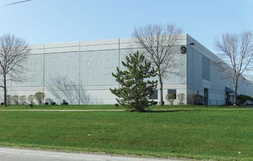

Property Detail
3550 Progress Way
290-20-03-09-0000-00
MS 1170 08SP(R/W .597 ANNEX) 95 SP FR 2900220180
Warehouse
Clinton
I2
Ohio
B and X Area of moderate flood hazard, usually the area between the limits of the 100-year and 500-year floods.
6.23 AC
2025
Ohio South Area
2025
Other Market Areas
964700
Wilmington, OH
102,400 SF
NEARBY LISTINGS FOR SALE OR LEASE
DEMOGRAPHICS near 3550 Progress Way
1 mile
3 mile
5 mile
2025 Total Population
46
5,461
15,633
2030 Population
46
5,444
15,632
Pop Growth 2025-2030
0.00%
(0.31%)
(0.01%)
Average Age
35
38
40
2025 Total Households
12
2,135
6,302
HH Growth 2025-2030
0.00%
(0.05%)
+ 0.10%
Median Household Inc
$67,500
$64,016
$59,386
Avg Household Size
2.40
2.20
2.30
2025 Avg HH Vehicles
2.00
2.00
2.00
Median Home Value
$150,000
$176,552
$188,554
Median Year Built
1974
1963
1976
Nearby Places
Map Layers
Map Styles
 Street
 Aerial
Layers
 Traffic
 Biking
Places
Listings with unknown addresses are not visible on the map
- Restaurants
- Banks
- Shops
- Fitness
- Groceries
PUBLIC TRANSPORTATION
AIRPORT
James M Cox Dayton International
Drive
Walk
Distance
James M Cox Dayton International
74 min
49.7 mi
Nearby Properties
Address
Land Use
TOTAL SIZE
Lot Size
Zoning
Address
Land Use
TOTAL SIZE
Lot Size
Zoning
9,000 SF
1,048.03 AC
Address
Land Use
TOTAL SIZE
Lot Size
Zoning
69,324 SF
46.77 AC
I2
Address
Land Use
TOTAL SIZE
Lot Size
Zoning
112,625 SF
4.46 AC
Address
Land Use
TOTAL SIZE
Lot Size
Zoning
12,200 SF
40.56 AC
I2
Address
Land Use
TOTAL SIZE
Lot Size
Zoning
404,416 SF
55.93 AC
Address
Land Use
TOTAL SIZE
Lot Size
Zoning
300,785 SF
19.79 AC
I2
Address
Land Use
TOTAL SIZE
Lot Size
Zoning
78.11 AC
Address
Land Use
TOTAL SIZE
Lot Size
Zoning
221,961 SF
8.97 AC
Address
Land Use
TOTAL SIZE
Lot Size
Zoning
83,588 SF
23.10 AC
I2
Address
Land Use
TOTAL SIZE
Lot Size
Zoning
202,778 SF
24.07 AC
RR
Address
Land Use
TOTAL SIZE
Lot Size
Zoning
12,525 SF
3.41 AC
Address
Land Use
TOTAL SIZE
Lot Size
Zoning
11,840 SF
17.56 AC
SR
Address
Land Use
TOTAL SIZE
Lot Size
Zoning
479.38 AC
Address
Land Use
TOTAL SIZE
Lot Size
Zoning
78,732 SF
20.31 AC
Address
Land Use
TOTAL SIZE
Lot Size
Zoning
18,124 SF
10 AC
Address
Land Use
TOTAL SIZE
Lot Size
Zoning
121,600 SF
7.23 AC
Address
Land Use
TOTAL SIZE
Lot Size
Zoning
121,600 SF
6.13 AC
Address
Land Use
TOTAL SIZE
Lot Size
Zoning
40,955 SF
7.18 AC
Address
Land Use
TOTAL SIZE
Lot Size
Zoning
97,636 SF
19.77 AC
Address
Land Use
TOTAL SIZE
Lot Size
Zoning
102,400 SF
6.45 AC
I2
Address
Land Use
TOTAL SIZE
Lot Size
Zoning
3,740 SF
1.18 AC
Address
Land Use
TOTAL SIZE
Lot Size
Zoning
102,400 SF
6.45 AC
I2
Address
Land Use
TOTAL SIZE
Lot Size
Zoning
102,400 SF
6.25 AC
I2
Address
Land Use
TOTAL SIZE
Lot Size
Zoning
102,400 SF
6.52 AC
I2
Address
Land Use
TOTAL SIZE
Lot Size
Zoning
8,707 SF
5.01 AC
Address
Land Use
TOTAL SIZE
Lot Size
Zoning
102,400 SF
6.23 AC
I2
Address
Land Use
TOTAL SIZE
Lot Size
Zoning
102,400 SF
6.45 AC
Address
Land Use
TOTAL SIZE
Lot Size
Zoning
12,449 SF
1.33 AC
Address
Land Use
TOTAL SIZE
Lot Size
Zoning
140,592 SF
20.05 AC
Address
Land Use
TOTAL SIZE
Lot Size
Zoning
37,924 SF
25.78 AC
RR
The World's #1 Commercial Real Estate Marketplace
Connect with us
© 2026 CoStar Group
The information above has been obtained from sources believed reliable. While we do not doubt its accuracy we have not verified it and make no guarantee, warranty or representation about it. It is your responsibility to independently confirm its accuracy and completeness. Any projections, opinions, assumptions, or estimates used are for example only and do not represent the current or future performance of the property. The value of this transaction to you depends on tax and other factors which should be evaluated by your tax, financial, and legal advisors. You and your advisors should conduct a careful, independent investigation of the property to determine to your satisfaction the suitability of the property for your needs.