Property Record
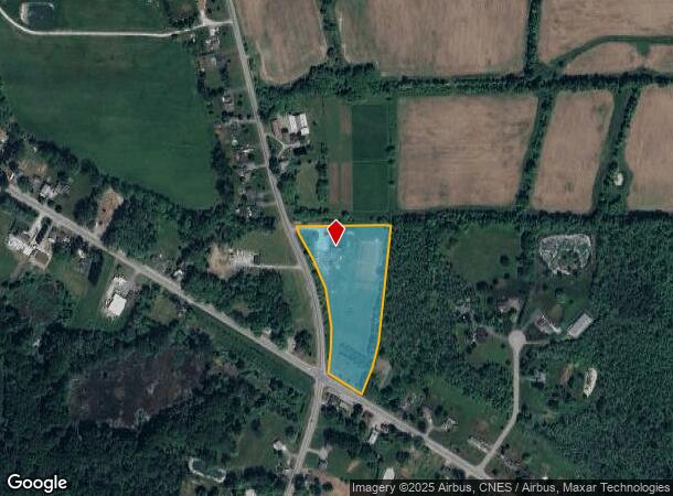
3550 Redman Rd, Brockport, NY 14420
NEARBY LISTINGS FOR SALE OR LEASE
-
-
View all Brockport listings for sale on LoopNet.com
Property Detail
3550 Redman Rd
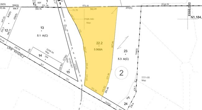
262489-039-030-0001-022-200
L2 S6 T4 TRI TRACT UNRECORDED MAP 7198-149
Horticulturegrowinghousesagricultural
Monroe
X
New York
36073C0355D
22.200
2025
5.97 AC
2024
Northwest
015200
Rochester
1,500 SF
Rochester, NY
DEMOGRAPHICS near 3550 Redman Rd
1 Mile
3 Mile
5 Mile
2024 Total Population
283
13,286
29,035
2029 Population
278
13,161
28,741
Pop Growth 2024-2029
(1.77%)
(0.94%)
(1.01%)
Average Age
42
37
40
2024 Total Households
105
4,853
11,437
HH Growth 2024-2029
(1.90%)
(0.93%)
(1.06%)
Median Household Inc
$77,678
$54,850
$59,953
Avg Household Size
2.60
2.30
2.30
2024 Avg HH Vehicles
2.00
2.00
2.00
Median Home Value
$208,000
$157,392
$152,359
Median Year Built
1971
1971
1973
Nearby Places
- Restaurants
- Banks
- Shops
- Fitness
- Groceries
PUBLIC TRANSPORTATION
AIRPORT
Frederick Douglass/Greater Rochester International
DRIVE
WALK
Distance
Frederick Douglass/Greater Rochester International
31 min
22.3 mi
Freight Ports
Albany, NY Port
DRIVE
WALK
Distance
Albany, NY Port
296 min
248.5 mi
Nearby Properties
Address
Land Use
TOTAL SIZE
Lot Size
Zoning
Address
Land Use
TOTAL SIZE
Lot Size
Zoning
149,713 SF
208.91 AC
R1-2
Address
Land Use
TOTAL SIZE
Lot Size
Zoning
220,772 SF
23.20 AC
R1-2
Address
Land Use
TOTAL SIZE
Lot Size
Zoning
86,408 SF
18.90 AC
COM
Address
Land Use
TOTAL SIZE
Lot Size
Zoning
8,928 SF
19.25 AC
02 - SINGL
Address
Land Use
TOTAL SIZE
Lot Size
Zoning
50,303 SF
12.07 AC
05 - COMME
Address
Land Use
TOTAL SIZE
Lot Size
Zoning
3,640 SF
11.91 AC
02 - SINGL
Address
Land Use
TOTAL SIZE
Lot Size
Zoning
47,576 SF
7.55 AC
05 - COMME
Address
Land Use
TOTAL SIZE
Lot Size
Zoning
13,548 SF
5.26 AC
C
Address
Land Use
TOTAL SIZE
Lot Size
Zoning
13,548 SF
5.40 AC
C
Address
Land Use
TOTAL SIZE
Lot Size
Zoning
3.10 AC
02 - SINGL
Address
Land Use
TOTAL SIZE
Lot Size
Zoning
13,548 SF
5.02 AC
RS-10
Address
Land Use
TOTAL SIZE
Lot Size
Zoning
13,548 SF
4.14 AC
RS-10
Address
Land Use
TOTAL SIZE
Lot Size
Zoning
30,960 SF
7.36 AC
RS-10
Address
Land Use
TOTAL SIZE
Lot Size
Zoning
8,448 SF
3.90 AC
05 - COMME
Address
Land Use
TOTAL SIZE
Lot Size
Zoning
1,200 SF
39.40 AC
05 - COMME
Address
Land Use
TOTAL SIZE
Lot Size
Zoning
56,290 SF
4.99 AC
C
Address
Land Use
TOTAL SIZE
Lot Size
Zoning
4,624 SF
3.40 AC
05 - COMME
Address
Land Use
TOTAL SIZE
Lot Size
Zoning
13,548 SF
2.86 AC
C
Address
Land Use
TOTAL SIZE
Lot Size
Zoning
23,294 SF
4.21 AC
HC
Address
Land Use
TOTAL SIZE
Lot Size
Zoning
44,400 SF
3.13 AC
HC
Address
Land Use
TOTAL SIZE
Lot Size
Zoning
37.16 AC
RS-20
Address
Land Use
TOTAL SIZE
Lot Size
Zoning
26.44 AC
Address
Land Use
TOTAL SIZE
Lot Size
Zoning
18,356 SF
1.30 AC
05 - COMME
Address
Land Use
TOTAL SIZE
Lot Size
Zoning
34.85 AC
RS-20
Address
Land Use
TOTAL SIZE
Lot Size
Zoning
27.69 AC
01 - NOT Z
Address
Land Use
TOTAL SIZE
Lot Size
Zoning
28,857 SF
3.60 AC
05 - COMME
Address
Land Use
TOTAL SIZE
Lot Size
Zoning
23,687 SF
22.52 AC
C
Address
Land Use
TOTAL SIZE
Lot Size
Zoning
15,808 SF
11 AC
C
Address
Land Use
TOTAL SIZE
Lot Size
Zoning
19.70 AC
Address
Land Use
TOTAL SIZE
Lot Size
Zoning
2,842 SF
0.11 AC
05 - COMME
The World's #1 Commercial Real Estate Marketplace
Connect with us
© 2025 CoStar Group
The information above has been obtained from sources believed reliable. While we do not doubt its accuracy we have not verified it and make no guarantee, warranty or representation about it. It is your responsibility to independently confirm its accuracy and completeness. Any projections, opinions, assumptions, or estimates used are for example only and do not represent the current or future performance of the property. The value of this transaction to you depends on tax and other factors which should be evaluated by your tax, financial, and legal advisors. You and your advisors should conduct a careful, independent investigation of the property to determine to your satisfaction the suitability of the property for your needs.