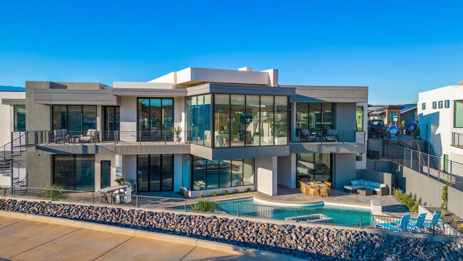
Property Record
3550 S Cypress Point Rd, Hurricane, UT 84737

NEARBY LISTINGS FOR SALE OR LEASE
-
-
View all Hurricane listings for sale on LoopNet.com
Property Detail
3550 S Cypress Point Rd
St. George, UT
Cliff View Estates Ph 1 Sub At Copper Ro
1044088
SUBDIVISION: CLIFF VIEW ESTATES AT COPPER ROCK 1 (H) LOT: 3
Sfr
Washington
X
Utah
49053C1100G
3
2024
0.25 AC
2025
Cedar City & St George
270905
Other Market Areas
5,647 SF
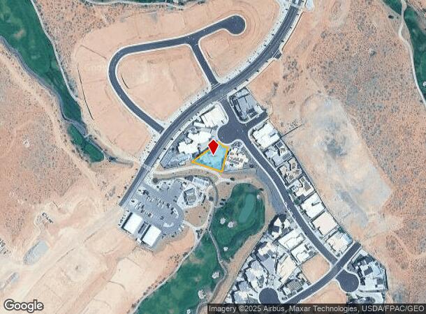
DEMOGRAPHICS near 3550 S Cypress Point Rd
1 mile
3 mile
5 mile
2024 Total Population
406
1,654
13,950
2029 Population
496
2,033
17,191
Pop Growth 2024-2029
+ 22.17%
+ 22.91%
+ 23.23%
Average Age
42
42
41
2024 Total Households
133
554
4,716
HH Growth 2024-2029
+ 22.56%
+ 23.47%
+ 24.07%
Median Household Inc
$55,833
$57,856
$62,356
Avg Household Size
2.90
2.90
2.90
2024 Avg HH Vehicles
2.00
2.00
2.00
Median Home Value
$630,281
$588,740
$438,913
Median Year Built
2000
2001
2004
Nearby Places
Map Layers
Map Styles
 Street
 Aerial
Transit
 Traffic
 Biking
Places
Listings with unknown addresses are not visible on the map
- Restaurants
- Banks
- Shops
- Fitness
- Groceries
PUBLIC TRANSPORTATION
AIRPORT
St George Regional
Drive
Walk
Distance
St George Regional
38 min
23.6 mi
Nearby Properties
Address
Land Use
TOTAL SIZE
Lot Size
Zoning
Address
Land Use
TOTAL SIZE
Lot Size
Zoning
423.24 AC
RA1
Address
Land Use
TOTAL SIZE
Lot Size
Zoning
1,155 SF
68.88 AC
APO
Address
Land Use
TOTAL SIZE
Lot Size
Zoning
4,913 SF
37.50 AC
A5
Address
Land Use
TOTAL SIZE
Lot Size
Zoning
1,708 SF
47.04 AC
RA1
Address
Land Use
TOTAL SIZE
Lot Size
Zoning
6,575 SF
104.64 AC
PD
Address
Land Use
TOTAL SIZE
Lot Size
Zoning
5,240 SF
35 AC
A20
Address
Land Use
TOTAL SIZE
Lot Size
Zoning
9,095 SF
0.69 AC
Address
Land Use
TOTAL SIZE
Lot Size
Zoning
10,929 SF
10.33 AC
Address
Land Use
TOTAL SIZE
Lot Size
Zoning
3,042 SF
31.34 AC
RA1
Address
Land Use
TOTAL SIZE
Lot Size
Zoning
7,710 SF
10.32 AC
Address
Land Use
TOTAL SIZE
Lot Size
Zoning
6,558 SF
0.47 AC
Address
Land Use
TOTAL SIZE
Lot Size
Zoning
5,729 SF
0.33 AC
Address
Land Use
TOTAL SIZE
Lot Size
Zoning
7,050 SF
0.50 AC
Address
Land Use
TOTAL SIZE
Lot Size
Zoning
11,372 SF
6.76 AC
A5
Address
Land Use
TOTAL SIZE
Lot Size
Zoning
6,969 SF
1.50 AC
RA1
Address
Land Use
TOTAL SIZE
Lot Size
Zoning
5,457 SF
0.39 AC
Address
Land Use
TOTAL SIZE
Lot Size
Zoning
12,186 SF
5.45 AC
Address
Land Use
TOTAL SIZE
Lot Size
Zoning
6,254 SF
10.31 AC
Address
Land Use
TOTAL SIZE
Lot Size
Zoning
11,610 SF
10 AC
RA1
Address
Land Use
TOTAL SIZE
Lot Size
Zoning
1,744 SF
19.32 AC
A5
Address
Land Use
TOTAL SIZE
Lot Size
Zoning
4,674 SF
0.24 AC
Address
Land Use
TOTAL SIZE
Lot Size
Zoning
8,540 SF
11 AC
A5
Address
Land Use
TOTAL SIZE
Lot Size
Zoning
4,613 SF
0.28 AC
Address
Land Use
TOTAL SIZE
Lot Size
Zoning
8,631 SF
10.32 AC
Address
Land Use
TOTAL SIZE
Lot Size
Zoning
9,722 SF
0.92 AC
RA1
Address
Land Use
TOTAL SIZE
Lot Size
Zoning
5,835 SF
7.71 AC
Address
Land Use
TOTAL SIZE
Lot Size
Zoning
4,664 SF
10.30 AC
Address
Land Use
TOTAL SIZE
Lot Size
Zoning
4,149 SF
0.24 AC
The World's #1 Commercial Real Estate Marketplace
Connect with us
© 2026 CoStar Group
The information above has been obtained from sources believed reliable. While we do not doubt its accuracy we have not verified it and make no guarantee, warranty or representation about it. It is your responsibility to independently confirm its accuracy and completeness. Any projections, opinions, assumptions, or estimates used are for example only and do not represent the current or future performance of the property. The value of this transaction to you depends on tax and other factors which should be evaluated by your tax, financial, and legal advisors. You and your advisors should conduct a careful, independent investigation of the property to determine to your satisfaction the suitability of the property for your needs.