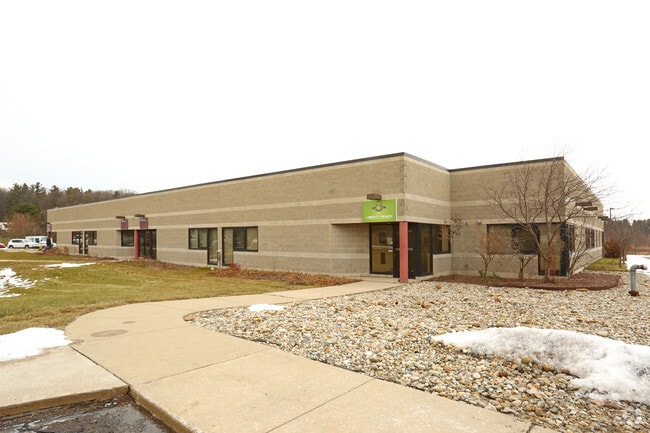
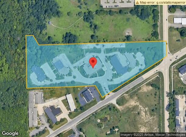
Property Record
3500 W Liberty Rd, Ann Arbor, MI 48103

Current Lease Availabilities
NEARBY LISTINGS FOR SALE OR LEASE
Property Detail
3500 W Liberty Rd
08-26-400-014
COM AT SE COR SEC 26, T2S, R5E; TH N 02-09-20 E 913.34 FT TO POB; TH S 60-49-00 W 680.24 FT; TH N 29-11-00 W 186.86 FT; TH N
Commercialnec
Washtenaw
X
Michigan
26161C0243E
12.95 AC
2025
Washtenaw W of 23
2025
Detroit
456000
Ann Arbor, MI
DEMOGRAPHICS near 3500 W Liberty Rd
1 Mile
3 Mile
5 Mile
2024 Total Population
3,912
50,852
122,309
2029 Population
3,857
50,672
121,077
Pop Growth 2024-2029
(1.41%)
(0.35%)
(1.01%)
Average Age
41
40
37
2024 Total Households
1,658
22,344
50,103
HH Growth 2024-2029
(1.51%)
(0.49%)
(0.99%)
Median Household Inc
$132,011
$104,958
$84,981
Avg Household Size
2.30
2.20
2.20
2024 Avg HH Vehicles
2.00
2.00
2.00
Median Home Value
$444,662
$438,355
$443,577
Median Year Built
1993
1972
1976
Nearby Places
Map Layers
Map Styles
 Street
 Aerial
- Restaurants
- Banks
- Shops
- Fitness
- Groceries
PUBLIC TRANSPORTATION
AIRPORT
Detroit Metro Wayne County
DRIVE
WALK
Distance
Detroit Metro Wayne County
31 min
29.4 mi
Freight Ports
Port of Baltimore
DRIVE
WALK
Distance
Port of Baltimore
1 min
430.3 mi
Nearby Properties
Address
Land Use
TOTAL SIZE
Lot Size
Zoning
Address
Land Use
TOTAL SIZE
Lot Size
Zoning
212,047 SF
1.15 AC
D2
Address
Land Use
TOTAL SIZE
Lot Size
Zoning
186,029 SF
2.06 AC
D2
Address
Land Use
TOTAL SIZE
Lot Size
Zoning
140,670 SF
1.63 AC
C2B
Address
Land Use
TOTAL SIZE
Lot Size
Zoning
177,763 SF
0.91 AC
D2
Address
Land Use
TOTAL SIZE
Lot Size
Zoning
303,524 SF
19.40 AC
R4B
Address
Land Use
TOTAL SIZE
Lot Size
Zoning
271,521 SF
15.11 AC
Address
Land Use
TOTAL SIZE
Lot Size
Zoning
268,002 SF
18.34 AC
Address
Land Use
TOTAL SIZE
Lot Size
Zoning
137,874 SF
0.55 AC
PUD
Address
Land Use
TOTAL SIZE
Lot Size
Zoning
234,076 SF
24.18 AC
R4A
Address
Land Use
TOTAL SIZE
Lot Size
Zoning
359,701 SF
37.70 AC
R4A
Address
Land Use
TOTAL SIZE
Lot Size
Zoning
231,262 SF
25.82 AC
C3
Address
Land Use
TOTAL SIZE
Lot Size
Zoning
179,981 SF
14.55 AC
R4A
Address
Land Use
TOTAL SIZE
Lot Size
Zoning
3,840 SF
1.55 AC
R4D
Address
Land Use
TOTAL SIZE
Lot Size
Zoning
177,474 SF
58.03 AC
C-2
Address
Land Use
TOTAL SIZE
Lot Size
Zoning
55,700 SF
1.21 AC
R4C
Address
Land Use
TOTAL SIZE
Lot Size
Zoning
182,625 SF
15.89 AC
C3
Address
Land Use
TOTAL SIZE
Lot Size
Zoning
13.77 AC
MR-3
Address
Land Use
TOTAL SIZE
Lot Size
Zoning
74,152 SF
31.63 AC
BI
Address
Land Use
TOTAL SIZE
Lot Size
Zoning
59.07 AC
R-C
Address
Land Use
TOTAL SIZE
Lot Size
Zoning
320 SF
20.95 AC
MR-3
Address
Land Use
TOTAL SIZE
Lot Size
Zoning
80,088 SF
1.44 AC
R4B
Address
Land Use
TOTAL SIZE
Lot Size
Zoning
92,340 SF
0.71 AC
PUD
Address
Land Use
TOTAL SIZE
Lot Size
Zoning
94,275 SF
10.65 AC
C1B
Address
Land Use
TOTAL SIZE
Lot Size
Zoning
85,468 SF
0.33 AC
PUD
Address
Land Use
TOTAL SIZE
Lot Size
Zoning
95,831 SF
26.98 AC
I-1
Address
Land Use
TOTAL SIZE
Lot Size
Zoning
112,525 SF
14.40 AC
BI
Address
Land Use
TOTAL SIZE
Lot Size
Zoning
180,899 SF
32.64 AC
C-2
Address
Land Use
TOTAL SIZE
Lot Size
Zoning
255,870 SF
32.37 AC
Address
Land Use
TOTAL SIZE
Lot Size
Zoning
38,511 SF
0.23 AC
D2
Address
Land Use
TOTAL SIZE
Lot Size
Zoning
112,722 SF
12.74 AC
C1B
The World's #1 Commercial Real Estate Marketplace
Connect with us
© 2026 CoStar Group
The information above has been obtained from sources believed reliable. While we do not doubt its accuracy we have not verified it and make no guarantee, warranty or representation about it. It is your responsibility to independently confirm its accuracy and completeness. Any projections, opinions, assumptions, or estimates used are for example only and do not represent the current or future performance of the property. The value of this transaction to you depends on tax and other factors which should be evaluated by your tax, financial, and legal advisors. You and your advisors should conduct a careful, independent investigation of the property to determine to your satisfaction the suitability of the property for your needs.