No Photo
Property Record
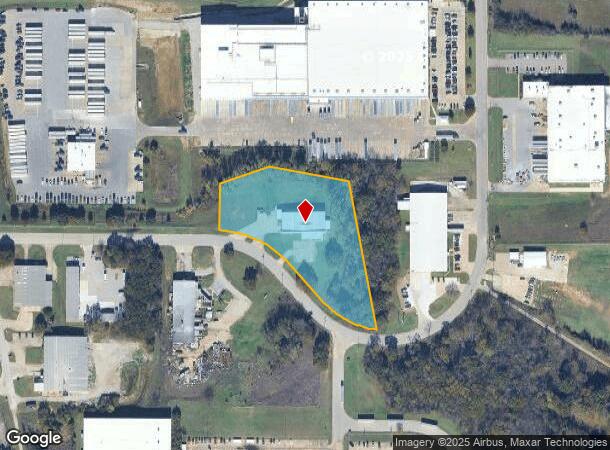
3551 Cypert Way, Ardmore, OK 73401
NEARBY LISTINGS FOR SALE OR LEASE
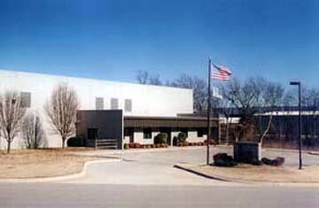
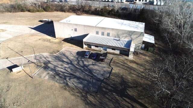
Property Detail
3551 Cypert Way
Ardmore, OK
Ardmore City Tracts
1990-07-05S-02E-2-014-00
PT W/2 OF SEC, BEG NW/C TRACT II NEW HORIZONS ADDN; N89.5726E 145'; N00.0234W 80'; CURVE TO R W/RADIUS 340' DISTANCE 20' TO TRUE POB; N00.0234W 150'; N70.1400E 171.03';S79.2539E 261.78'; S11.1851E 486.51; C/RIGHT RADIUS 280, ARC DIST 202.73 CHORD BEA
Manufacturinglight
Carter
X
Oklahoma
40019C0445C
2e
2024
3.33 AC
2025
Oklahoma East Area
893001
Other Market Areas
1,066 SF
DEMOGRAPHICS near 3551 Cypert Way
1 Mile
3 Mile
5 Mile
2024 Total Population
186
13,329
28,681
2029 Population
191
13,751
29,558
Pop Growth 2024-2029
+ 2.69%
+ 3.17%
+ 3.06%
Average Age
40
41
40
2024 Total Households
68
5,232
11,392
HH Growth 2024-2029
+ 2.94%
+ 3.15%
+ 3.03%
Median Household Inc
$64,500
$47,695
$48,867
Avg Household Size
2.70
2.40
2.40
2024 Avg HH Vehicles
2.00
2.00
2.00
Median Home Value
$204,000
$153,287
$146,604
Median Year Built
1980
1965
1971
Nearby Places
Map Layers
Map Styles
 Street
 Aerial
- Restaurants
- Banks
- Shops
- Fitness
- Groceries
PUBLIC TRANSPORTATION
COMMUTER RAIL
DRIVE
WALK
Distance
8 min
4.0 mi
SALE & LEASE HISTORY
LISTING DATE
SALE/LEASE

Nov 10, 2016
For Sale
Mar 22, 2022
For Sale
Nearby Properties
Address
Land Use
TOTAL SIZE
Lot Size
Zoning
Address
Land Use
TOTAL SIZE
Lot Size
Zoning
1,020 SF
34.64 AC
C1
Address
Land Use
TOTAL SIZE
Lot Size
Zoning
828 SF
12.24 AC
C1
Address
Land Use
TOTAL SIZE
Lot Size
Zoning
3,188 SF
2.75 AC
C1
Address
Land Use
TOTAL SIZE
Lot Size
Zoning
1,479 SF
2.33 AC
C1
Address
Land Use
TOTAL SIZE
Lot Size
Zoning
7,560 SF
7.26 AC
C1
Address
Land Use
TOTAL SIZE
Lot Size
Zoning
3,078 SF
1.53 AC
C1
Address
Land Use
TOTAL SIZE
Lot Size
Zoning
11,664 SF
11.46 AC
C1
Address
Land Use
TOTAL SIZE
Lot Size
Zoning
5,889 SF
2.62 AC
C1
Address
Land Use
TOTAL SIZE
Lot Size
Zoning
3,150 SF
0.92 AC
C1
Address
Land Use
TOTAL SIZE
Lot Size
Zoning
36,800 SF
1.10 AC
C1
Address
Land Use
TOTAL SIZE
Lot Size
Zoning
444 SF
12.92 AC
C1
Address
Land Use
TOTAL SIZE
Lot Size
Zoning
3,294 SF
5.38 AC
C1
Address
Land Use
TOTAL SIZE
Lot Size
Zoning
3,125 SF
10 AC
C1
Address
Land Use
TOTAL SIZE
Lot Size
Zoning
1,000 SF
1.63 AC
C1
Address
Land Use
TOTAL SIZE
Lot Size
Zoning
2,500 SF
10 AC
C1
Address
Land Use
TOTAL SIZE
Lot Size
Zoning
6,664 SF
0.15 AC
C1
Address
Land Use
TOTAL SIZE
Lot Size
Zoning
5,588 SF
7.25 AC
C1
Address
Land Use
TOTAL SIZE
Lot Size
Zoning
3,985 SF
10 AC
C1
Address
Land Use
TOTAL SIZE
Lot Size
Zoning
336 SF
0.34 AC
C1
Address
Land Use
TOTAL SIZE
Lot Size
Zoning
5,840 SF
0.41 AC
C1
Address
Land Use
TOTAL SIZE
Lot Size
Zoning
55,440 SF
10.01 AC
C1
Address
Land Use
TOTAL SIZE
Lot Size
Zoning
3,972 SF
1.13 AC
C1
Address
Land Use
TOTAL SIZE
Lot Size
Zoning
2,282 SF
5 AC
R1
Address
Land Use
TOTAL SIZE
Lot Size
Zoning
888 SF
1.09 AC
C1
Address
Land Use
TOTAL SIZE
Lot Size
Zoning
980 SF
23.12 AC
C1
Address
Land Use
TOTAL SIZE
Lot Size
Zoning
732 SF
5.66 AC
C1
Address
Land Use
TOTAL SIZE
Lot Size
Zoning
7,436 SF
1.36 AC
C1
Address
Land Use
TOTAL SIZE
Lot Size
Zoning
281 SF
0.78 AC
C1
Address
Land Use
TOTAL SIZE
Lot Size
Zoning
5,246 SF
1.10 AC
Address
Land Use
TOTAL SIZE
Lot Size
Zoning
10,729 SF
1.33 AC
The World's #1 Commercial Real Estate Marketplace
Connect with us
© 2025 CoStar Group
The information above has been obtained from sources believed reliable. While we do not doubt its accuracy we have not verified it and make no guarantee, warranty or representation about it. It is your responsibility to independently confirm its accuracy and completeness. Any projections, opinions, assumptions, or estimates used are for example only and do not represent the current or future performance of the property. The value of this transaction to you depends on tax and other factors which should be evaluated by your tax, financial, and legal advisors. You and your advisors should conduct a careful, independent investigation of the property to determine to your satisfaction the suitability of the property for your needs.