Property Record
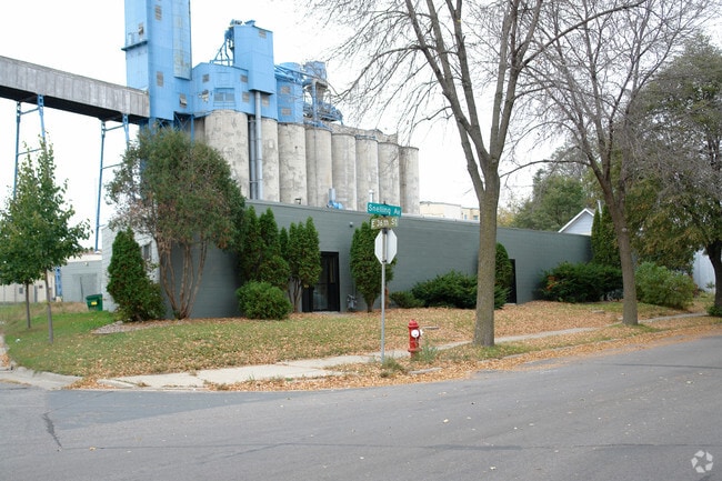
3556 Snelling Ave, Minneapolis, MN 55406


Current Lease Availabilities
NEARBY LISTINGS FOR SALE OR LEASE
Property Detail
3556 Snelling Ave
Minneapolis-St. Paul-Bloomington, MN-WI
Palmer's Addition To Minneapolis
01-028-24-41-0094
LOT 017 BLOCK 008 A PALMERS ADDN TO MPLS LOTS 16 TO 19 INCL NE 149X168X73X150
Industrialgeneral
Hennepin
X
Minnesota
27053C0378F
17
2024
0.38 AC
2024
Minneapolis
108800
Minneapolis/St Paul
10,720 SF
DEMOGRAPHICS near 3556 Snelling Ave
1 Mile
3 Mile
5 Mile
2024 Total Population
24,764
218,163
477,186
2029 Population
24,313
214,477
469,192
Pop Growth 2024-2029
(1.82%)
(1.69%)
(1.68%)
Average Age
39
37
37
2024 Total Households
10,759
91,630
214,396
HH Growth 2024-2029
(1.99%)
(1.76%)
(1.67%)
Median Household Inc
$74,482
$66,649
$72,277
Avg Household Size
2.20
2.10
2.10
2024 Avg HH Vehicles
2.00
1.00
1.00
Median Home Value
$283,412
$332,854
$351,900
Median Year Built
1946
1949
1954
Nearby Places
Map Layers
Map Styles
 Street
 Aerial
- Restaurants
- Banks
- Shops
- Fitness
- Groceries
PUBLIC TRANSPORTATION
TRANSIT/SUBWAY
38Th Street Station (Hiawatha Line - Minneapolis-Saint Paul Metro Transit Light Rail)
DRIVE
WALK
Distance
38Th Street Station (Hiawatha Line - Minneapolis-Saint Paul Metro Transit Light Rail)
2 min
8 min
0.4 mi
Lake Street/Midtown Station (Hiawatha Line - Minneapolis-Saint Paul Metro Transit Light Rail)
DRIVE
WALK
Distance
Lake Street/Midtown Station (Hiawatha Line - Minneapolis-Saint Paul Metro Transit Light Rail)
3 min
18 min
0.9 mi
COMMUTER RAIL
Target Field Station (Northstar Corridor - Northstar Commuter Rail)
DRIVE
WALK
Distance
Target Field Station (Northstar Corridor - Northstar Commuter Rail)
11 min
4.3 mi
St. Paul-Minneapolis (Empire Builder - Amtrak)
DRIVE
WALK
Distance
St. Paul-Minneapolis (Empire Builder - Amtrak)
18 min
8.4 mi
AIRPORT
Minneapolis-St Paul International/Wold-Chamberlain
DRIVE
WALK
Distance
Minneapolis-St Paul International/Wold-Chamberlain
15 min
7.1 mi
Freight Ports
Port Milwaukee
DRIVE
WALK
Distance
Port Milwaukee
377 min
336.7 mi
Nearby Properties
Address
Land Use
TOTAL SIZE
Lot Size
Zoning
Address
Land Use
TOTAL SIZE
Lot Size
Zoning
141,277 SF
44.78 AC
Address
Land Use
TOTAL SIZE
Lot Size
Zoning
84,316 SF
40.83 AC
Address
Land Use
TOTAL SIZE
Lot Size
Zoning
504,049 SF
75.43 AC
Address
Land Use
TOTAL SIZE
Lot Size
Zoning
Address
Land Use
TOTAL SIZE
Lot Size
Zoning
495,632 SF
1.72 AC
C1
Address
Land Use
TOTAL SIZE
Lot Size
Zoning
176,108 SF
27.45 AC
Address
Land Use
TOTAL SIZE
Lot Size
Zoning
458,470 SF
1.18 AC
OR3
Address
Land Use
TOTAL SIZE
Lot Size
Zoning
577,656 SF
2.92 AC
C3A
Address
Land Use
TOTAL SIZE
Lot Size
Zoning
2.65 AC
Address
Land Use
TOTAL SIZE
Lot Size
Zoning
398,356 SF
1.14 AC
B4N
Address
Land Use
TOTAL SIZE
Lot Size
Zoning
267,530 SF
28.60 AC
Address
Land Use
TOTAL SIZE
Lot Size
Zoning
546,882 SF
2.64 AC
R6
Address
Land Use
TOTAL SIZE
Lot Size
Zoning
344,458 SF
1.64 AC
C3A
Address
Land Use
TOTAL SIZE
Lot Size
Zoning
321,828 SF
0.77 AC
I1
Address
Land Use
TOTAL SIZE
Lot Size
Zoning
423,037 SF
0.28 AC
C3A
Address
Land Use
TOTAL SIZE
Lot Size
Zoning
3,200 SF
0.14 AC
Address
Land Use
TOTAL SIZE
Lot Size
Zoning
282,086 SF
2.51 AC
B4N
Address
Land Use
TOTAL SIZE
Lot Size
Zoning
518,750 SF
3.58 AC
Address
Land Use
TOTAL SIZE
Lot Size
Zoning
291,264 SF
1.61 AC
C3A
Address
Land Use
TOTAL SIZE
Lot Size
Zoning
245,477 SF
1.32 AC
C3A
Address
Land Use
TOTAL SIZE
Lot Size
Zoning
386,583 SF
1.79 AC
OR2
Address
Land Use
TOTAL SIZE
Lot Size
Zoning
200,892 SF
3.60 AC
Address
Land Use
TOTAL SIZE
Lot Size
Zoning
372,143 SF
2.11 AC
C3A
Address
Land Use
TOTAL SIZE
Lot Size
Zoning
313,892 SF
2.03 AC
R5
Address
Land Use
TOTAL SIZE
Lot Size
Zoning
251,619 SF
1.20 AC
Address
Land Use
TOTAL SIZE
Lot Size
Zoning
244,186 SF
0.72 AC
C3A
Address
Land Use
TOTAL SIZE
Lot Size
Zoning
Address
Land Use
TOTAL SIZE
Lot Size
Zoning
318,765 SF
3.58 AC
Address
Land Use
TOTAL SIZE
Lot Size
Zoning
261,098 SF
24.12 AC
Address
Land Use
TOTAL SIZE
Lot Size
Zoning
429,720 SF
6.02 AC
The World's #1 Commercial Real Estate Marketplace
Connect with us
© 2025 CoStar Group
The information above has been obtained from sources believed reliable. While we do not doubt its accuracy we have not verified it and make no guarantee, warranty or representation about it. It is your responsibility to independently confirm its accuracy and completeness. Any projections, opinions, assumptions, or estimates used are for example only and do not represent the current or future performance of the property. The value of this transaction to you depends on tax and other factors which should be evaluated by your tax, financial, and legal advisors. You and your advisors should conduct a careful, independent investigation of the property to determine to your satisfaction the suitability of the property for your needs.