Property Record
3556 S Ashland Ave, Chicago, IL 60609
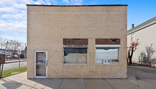

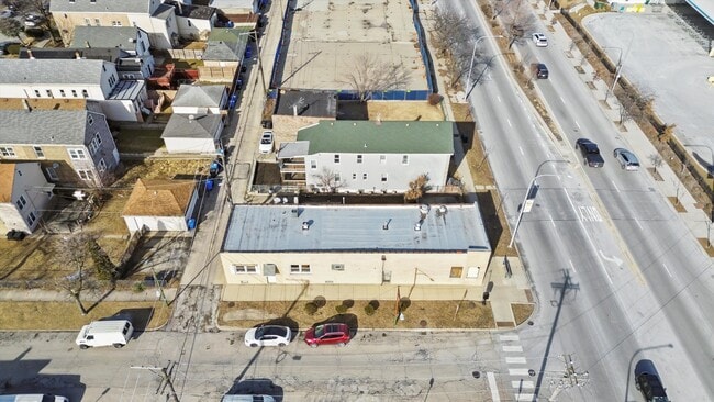
This Property Is For Sale
NEARBY LISTINGS FOR SALE OR LEASE
Property Detail
3556 S Ashland Ave
Chicago-Naperville-Elgin, IL-IN-WI
Jordans Sub
17-31-407-038-0000
T M (JORDANS) SUB OF BLK 21 OF CANAL TRUSTEES SUB OF EH SEC 31-39-14
Miscresidentialimprovement
Cook
X
Illinois
17031C0508J
24
2023
0.05 AC
2024
South Chicago
842600
Chicago
2,208 SF
DEMOGRAPHICS near 3556 S Ashland Ave
1 Mile
3 Mile
5 Mile
2024 Total Population
21,178
279,994
842,621
2029 Population
19,029
255,841
798,233
Pop Growth 2024-2029
(10.15%)
(8.63%)
(5.27%)
Average Age
38
37
37
2024 Total Households
7,812
101,315
343,384
HH Growth 2024-2029
(10.69%)
(8.51%)
(4.55%)
Median Household Inc
$69,115
$48,444
$62,928
Avg Household Size
2.60
2.60
2.30
2024 Avg HH Vehicles
1.00
1.00
1.00
Median Home Value
$325,940
$276,456
$298,898
Median Year Built
1947
1949
1959
Nearby Places
Map Layers
Map Styles
 Street
 Aerial
- Restaurants
- Banks
- Shops
- Fitness
- Groceries
PUBLIC TRANSPORTATION
TRANSIT/SUBWAY
Ashland Station (Orange Line) (Orange Line - Chicago Transit Authority "L" Trains (The "L"))
DRIVE
WALK
Distance
Ashland Station (Orange Line) (Orange Line - Chicago Transit Authority "L" Trains (The "L"))
3 min
15 min
0.8 mi
35th/Archer Station (Orange Line - Chicago Transit Authority "L" Trains (The "L"))
DRIVE
WALK
Distance
35th/Archer Station (Orange Line - Chicago Transit Authority "L" Trains (The "L"))
3 min
16 min
0.8 mi
COMMUTER RAIL
DRIVE
WALK
Distance
5 min
2.1 mi
Halsted Station (Burlington Northern-Santa Fe Railway Line - Northeast Illinois Regional Commuter Railroad (Metra))
DRIVE
WALK
Distance
Halsted Station (Burlington Northern-Santa Fe Railway Line - Northeast Illinois Regional Commuter Railroad (Metra))
7 min
2.9 mi
AIRPORT
Chicago Midway International
DRIVE
WALK
Distance
Chicago Midway International
12 min
5.8 mi
Chicago O'Hare International
DRIVE
WALK
Distance
Chicago O'Hare International
34 min
20.6 mi
Nearby Properties
Address
Land Use
TOTAL SIZE
Lot Size
Zoning
Address
Land Use
TOTAL SIZE
Lot Size
Zoning
1,215,367 SF
3.76 AC
PD 675
Address
Land Use
TOTAL SIZE
Lot Size
Zoning
474,979 SF
29.67 AC
PD 553
Address
Land Use
TOTAL SIZE
Lot Size
Zoning
590,844 SF
0.80 AC
PD 26
Address
Land Use
TOTAL SIZE
Lot Size
Zoning
0.85 AC
DS-3
Address
Land Use
TOTAL SIZE
Lot Size
Zoning
4.71 AC
PD 1196
Address
Land Use
TOTAL SIZE
Lot Size
Zoning
4.11 AC
M2-3
Address
Land Use
TOTAL SIZE
Lot Size
Zoning
2.98 AC
PD 1196
Address
Land Use
TOTAL SIZE
Lot Size
Zoning
134,800 SF
2.53 AC
PD 1273
Address
Land Use
TOTAL SIZE
Lot Size
Zoning
548,210 SF
1.11 AC
PD 681
Address
Land Use
TOTAL SIZE
Lot Size
Zoning
111,322 SF
1 AC
DS-5
Address
Land Use
TOTAL SIZE
Lot Size
Zoning
1.82 AC
PD 30
Address
Land Use
TOTAL SIZE
Lot Size
Zoning
250,040 SF
15.70 AC
PD 1169
Address
Land Use
TOTAL SIZE
Lot Size
Zoning
27.31 AC
PD 1424
Address
Land Use
TOTAL SIZE
Lot Size
Zoning
136,720 SF
0.54 AC
PD 1
Address
Land Use
TOTAL SIZE
Lot Size
Zoning
225,784 SF
0.69 AC
DS-3
Address
Land Use
TOTAL SIZE
Lot Size
Zoning
169,435 SF
11.35 AC
PD 307
Address
Land Use
TOTAL SIZE
Lot Size
Zoning
313,559 SF
PD 1318
Address
Land Use
TOTAL SIZE
Lot Size
Zoning
307,277 SF
9.90 AC
PMD 11
Address
Land Use
TOTAL SIZE
Lot Size
Zoning
10 AC
PD 1169
Address
Land Use
TOTAL SIZE
Lot Size
Zoning
8.54 AC
PD 1169
Address
Land Use
TOTAL SIZE
Lot Size
Zoning
1,687,020 SF
10.25 AC
PD 1169
Address
Land Use
TOTAL SIZE
Lot Size
Zoning
1.97 AC
PD 30
Address
Land Use
TOTAL SIZE
Lot Size
Zoning
475,000 SF
14.01 AC
PMD 8
Address
Land Use
TOTAL SIZE
Lot Size
Zoning
363,780 SF
1.77 AC
PD 66
Address
Land Use
TOTAL SIZE
Lot Size
Zoning
Address
Land Use
TOTAL SIZE
Lot Size
Zoning
0.84 AC
B1-3
Address
Land Use
TOTAL SIZE
Lot Size
Zoning
633,057 SF
34.96 AC
PMD 8
Address
Land Use
TOTAL SIZE
Lot Size
Zoning
240,400 SF
1.34 AC
PMD 11
Address
Land Use
TOTAL SIZE
Lot Size
Zoning
72,893 SF
4.43 AC
PD 90
Address
Land Use
TOTAL SIZE
Lot Size
Zoning
72,259 SF
5.51 AC
PD 450
The World's #1 Commercial Real Estate Marketplace
Connect with us
© 2025 CoStar Group
The information above has been obtained from sources believed reliable. While we do not doubt its accuracy we have not verified it and make no guarantee, warranty or representation about it. It is your responsibility to independently confirm its accuracy and completeness. Any projections, opinions, assumptions, or estimates used are for example only and do not represent the current or future performance of the property. The value of this transaction to you depends on tax and other factors which should be evaluated by your tax, financial, and legal advisors. You and your advisors should conduct a careful, independent investigation of the property to determine to your satisfaction the suitability of the property for your needs.