Property Record
366 Old Maple Ave, North Haven, CT 06473

Property Detail
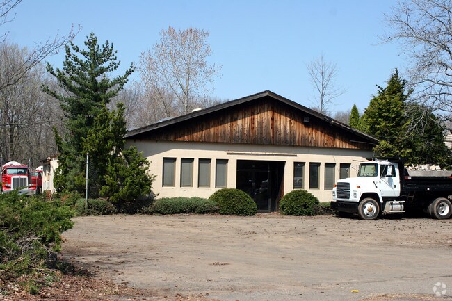
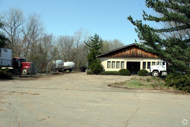
366 Old Maple Ave
NRHV-000037-000000-000092
South Central Ct
Warehouse
Connecticut
IL80
92
AE The base floodplain where base flood elevations are provided. AE Zones are now used on new format FIRMs instead of A1-A30 Zones.
1 AC
2025
North Haven
2025
Westchester/So Connecticut
167201
New Haven, CT
5,400 SF
NEARBY LISTINGS FOR SALE OR LEASE
DEMOGRAPHICS near 366 Old Maple Ave
1 mile
3 mile
5 mile
2025 Total Population
4,577
39,871
149,144
2030 Population
4,649
40,467
150,315
Pop Growth 2025-2030
+ 1.57%
+ 1.49%
+ 0.79%
Average Age
45
44
41
2025 Total Households
1,794
15,889
59,386
HH Growth 2025-2030
+ 1.51%
+ 1.45%
+ 0.96%
Median Household Inc
$104,520
$103,519
$77,365
Avg Household Size
2.50
2.50
2.30
2025 Avg HH Vehicles
2.00
2.00
2.00
Median Home Value
$357,499
$352,048
$327,063
Median Year Built
1961
1964
1963
Nearby Places
Map Layers
Map Styles
 Street
 Aerial
Transit
 Traffic
 Biking
Places
Listings with unknown addresses are not visible on the map
- Restaurants
- Banks
- Shops
- Fitness
- Groceries
PUBLIC TRANSPORTATION
COMMUTER RAIL
New Haven-State Street Station (Hartford Line - CONN DOT, New Haven Line - CONN DOT, Shore Line East - CONN DOT)
Drive
Walk
Distance
New Haven-State Street Station (Hartford Line - CONN DOT, New Haven Line - CONN DOT, Shore Line East - CONN DOT)
12 min
6.6 mi
New Haven Union Station (Hartford Line - CONN DOT)
Drive
Walk
Distance
New Haven Union Station (Hartford Line - CONN DOT)
13 min
7.3 mi
AIRPORT
Tweed/New Haven
Drive
Walk
Distance
Tweed/New Haven
18 min
9.1 mi
Freight Ports
Port of New Haven
Drive
Walk
Distance
Port of New Haven
14 min
6.8 mi
Nearby Properties
Address
Land Use
TOTAL SIZE
Lot Size
Zoning
Address
Land Use
TOTAL SIZE
Lot Size
Zoning
268,989 SF
22.59 AC
R20
Address
Land Use
TOTAL SIZE
Lot Size
Zoning
54 AC
R-3
Address
Land Use
TOTAL SIZE
Lot Size
Zoning
72,007 SF
1.79 AC
RS2
Address
Land Use
TOTAL SIZE
Lot Size
Zoning
66.68 AC
IG80
Address
Land Use
TOTAL SIZE
Lot Size
Zoning
31.34 AC
IL30
Address
Land Use
TOTAL SIZE
Lot Size
Zoning
17.71 AC
IL80
Address
Land Use
TOTAL SIZE
Lot Size
Zoning
57,467 SF
3.72 AC
T4
Address
Land Use
TOTAL SIZE
Lot Size
Zoning
134,029 SF
27.54 AC
R20
Address
Land Use
TOTAL SIZE
Lot Size
Zoning
97,898 SF
11.40 AC
R20
Address
Land Use
TOTAL SIZE
Lot Size
Zoning
85,000 SF
14 AC
R4
Address
Land Use
TOTAL SIZE
Lot Size
Zoning
23.40 AC
IG80
Address
Land Use
TOTAL SIZE
Lot Size
Zoning
27.36 AC
IL80
Address
Land Use
TOTAL SIZE
Lot Size
Zoning
10.70 AC
IL30
Address
Land Use
TOTAL SIZE
Lot Size
Zoning
119,658 SF
7.48 AC
O12
Address
Land Use
TOTAL SIZE
Lot Size
Zoning
3 AC
T5
Address
Land Use
TOTAL SIZE
Lot Size
Zoning
213,892 SF
8 AC
IL30
Address
Land Use
TOTAL SIZE
Lot Size
Zoning
17,949 SF
8.02 AC
CB40
Address
Land Use
TOTAL SIZE
Lot Size
Zoning
15.57 AC
IL80
Address
Land Use
TOTAL SIZE
Lot Size
Zoning
85,974 SF
7.05 AC
T-4
Address
Land Use
TOTAL SIZE
Lot Size
Zoning
9.80 AC
CA20
Address
Land Use
TOTAL SIZE
Lot Size
Zoning
15,432 SF
5.67 AC
CB40
Address
Land Use
TOTAL SIZE
Lot Size
Zoning
17.73 AC
IL30
Address
Land Use
TOTAL SIZE
Lot Size
Zoning
20.01 AC
R20
Address
Land Use
TOTAL SIZE
Lot Size
Zoning
4.45 AC
CB40
Address
Land Use
TOTAL SIZE
Lot Size
Zoning
125,680 SF
10.70 AC
IL80
Address
Land Use
TOTAL SIZE
Lot Size
Zoning
59,567 SF
20.43 AC
T4
Address
Land Use
TOTAL SIZE
Lot Size
Zoning
8.90 AC
CB40
Address
Land Use
TOTAL SIZE
Lot Size
Zoning
9.20 AC
CB40
Address
Land Use
TOTAL SIZE
Lot Size
Zoning
91,455 SF
14.20 AC
RU-2
Address
Land Use
TOTAL SIZE
Lot Size
Zoning
7.21 AC
IL30
The World's #1 Commercial Real Estate Marketplace
Connect with us
© 2026 CoStar Group
The information above has been obtained from sources believed reliable. While we do not doubt its accuracy we have not verified it and make no guarantee, warranty or representation about it. It is your responsibility to independently confirm its accuracy and completeness. Any projections, opinions, assumptions, or estimates used are for example only and do not represent the current or future performance of the property. The value of this transaction to you depends on tax and other factors which should be evaluated by your tax, financial, and legal advisors. You and your advisors should conduct a careful, independent investigation of the property to determine to your satisfaction the suitability of the property for your needs.