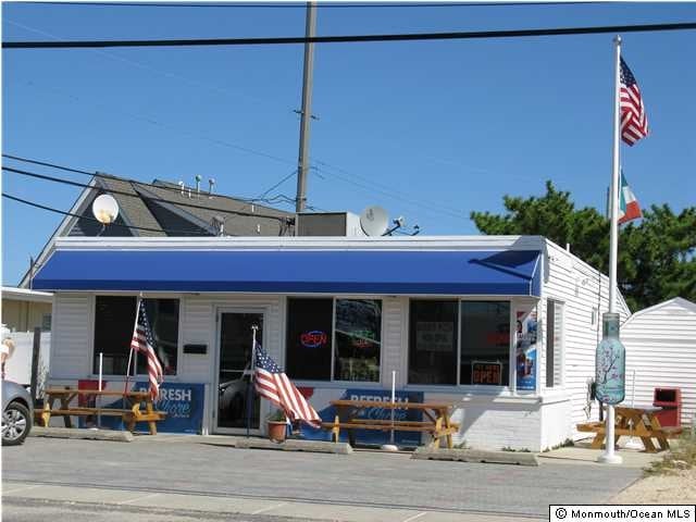
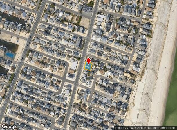
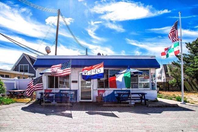
Property Record
3564 Route 35 N, Lavallette, NJ 08735
NEARBY LISTINGS FOR SALE OR LEASE
Property Detail
3564 Route 35 N
08-01089-0000-00106
77X66
Commercialnec
Ocean
VE
New Jersey
34029C0331F
106
2024
0.12 AC
2025
Ocean County
722500
Northern New Jersey
980 SF
Lakewood-New Brunswick, NJ
DEMOGRAPHICS near 3564 Route 35 N
1 mile
3 mile
5 mile
2024 Total Population
6,466
21,406
78,991
2029 Population
7,819
25,105
87,737
Pop Growth 2024-2029
+ 20.92%
+ 17.28%
+ 11.07%
Average Age
58
53
45
2024 Total Households
3,509
10,519
33,362
HH Growth 2024-2029
+ 20.83%
+ 17.50%
+ 11.47%
Median Household Inc
$59,546
$91,071
$91,250
Avg Household Size
1.80
2.00
2.30
2024 Avg HH Vehicles
2.00
2.00
2.00
Median Home Value
$675,567
$667,828
$434,794
Median Year Built
1975
1980
1974
Nearby Places
Map Layers
Map Styles
 Street
 Aerial
Transit
 Traffic
 Biking
Places
Listings with unknown addresses are not visible on the map
- Restaurants
- Banks
- Shops
- Fitness
- Groceries
PUBLIC TRANSPORTATION
COMMUTER RAIL
Bay Head (North Jersey Coast Line - NJ Transit Commuter Rail (NJ Transit))
Drive
Walk
Distance
Bay Head (North Jersey Coast Line - NJ Transit Commuter Rail (NJ Transit))
12 min
5.7 mi
Point Pleasant Beach (North Jersey Coast Line - NJ Transit Commuter Rail (NJ Transit))
Drive
Walk
Distance
Point Pleasant Beach (North Jersey Coast Line - NJ Transit Commuter Rail (NJ Transit))
13 min
6.8 mi
Freight Ports
New York Container Terminal
Drive
Walk
Distance
New York Container Terminal
77 min
56.4 mi
SALE & LEASE HISTORY
LISTING DATE
SALE/LEASE

Sep 24, 2016
For Sale
Aug 30, 2017
For Sale
Nearby Properties
Address
Land Use
TOTAL SIZE
Lot Size
Zoning
Address
Land Use
TOTAL SIZE
Lot Size
Zoning
117 AC
RR1
Address
Land Use
TOTAL SIZE
Lot Size
Zoning
2.67 AC
SMF
Address
Land Use
TOTAL SIZE
Lot Size
Zoning
1,497 SF
0.38 AC
R-3A
Address
Land Use
TOTAL SIZE
Lot Size
Zoning
20,353 SF
1.77 AC
R-1
Address
Land Use
TOTAL SIZE
Lot Size
Zoning
Address
Land Use
TOTAL SIZE
Lot Size
Zoning
29,422 SF
1.30 AC
Address
Land Use
TOTAL SIZE
Lot Size
Zoning
1.29 AC
Address
Land Use
TOTAL SIZE
Lot Size
Zoning
1,677 SF
3 AC
R-3A
Address
Land Use
TOTAL SIZE
Lot Size
Zoning
10,003 SF
0.32 AC
PU
Address
Land Use
TOTAL SIZE
Lot Size
Zoning
1.23 AC
SMF
Address
Land Use
TOTAL SIZE
Lot Size
Zoning
13,364 SF
1.24 AC
R-1
Address
Land Use
TOTAL SIZE
Lot Size
Zoning
8,773 SF
0.81 AC
R-1
Address
Land Use
TOTAL SIZE
Lot Size
Zoning
6,154 SF
0.82 AC
R-1
Address
Land Use
TOTAL SIZE
Lot Size
Zoning
7,604 SF
0.82 AC
R-1
Address
Land Use
TOTAL SIZE
Lot Size
Zoning
1,679 SF
2.17 AC
SMF
Address
Land Use
TOTAL SIZE
Lot Size
Zoning
6,177 SF
0.87 AC
R-1
Address
Land Use
TOTAL SIZE
Lot Size
Zoning
9,610 SF
0.87 AC
R-1
Address
Land Use
TOTAL SIZE
Lot Size
Zoning
2,335 SF
0.46 AC
R-2A
Address
Land Use
TOTAL SIZE
Lot Size
Zoning
10,825 SF
0.86 AC
R-1
Address
Land Use
TOTAL SIZE
Lot Size
Zoning
7,659 SF
0.93 AC
R100
Address
Land Use
TOTAL SIZE
Lot Size
Zoning
7,302 SF
0.78 AC
R-2A
Address
Land Use
TOTAL SIZE
Lot Size
Zoning
6,856 SF
0.68 AC
R-2A
Address
Land Use
TOTAL SIZE
Lot Size
Zoning
6,344 SF
0.84 AC
R-1
Address
Land Use
TOTAL SIZE
Lot Size
Zoning
6,861 SF
0.85 AC
R-1
Address
Land Use
TOTAL SIZE
Lot Size
Zoning
13,639 SF
0.80 AC
R-1
Address
Land Use
TOTAL SIZE
Lot Size
Zoning
12,154 SF
0.81 AC
R-1
Address
Land Use
TOTAL SIZE
Lot Size
Zoning
8,295 SF
1.11 AC
R-2A
Address
Land Use
TOTAL SIZE
Lot Size
Zoning
6,859 SF
0.55 AC
R-1
Address
Land Use
TOTAL SIZE
Lot Size
Zoning
8,329 SF
0.82 AC
R-1
Address
Land Use
TOTAL SIZE
Lot Size
Zoning
7,297 SF
0.82 AC
R-1
The World's #1 Commercial Real Estate Marketplace
Connect with us
© 2026 CoStar Group
The information above has been obtained from sources believed reliable. While we do not doubt its accuracy we have not verified it and make no guarantee, warranty or representation about it. It is your responsibility to independently confirm its accuracy and completeness. Any projections, opinions, assumptions, or estimates used are for example only and do not represent the current or future performance of the property. The value of this transaction to you depends on tax and other factors which should be evaluated by your tax, financial, and legal advisors. You and your advisors should conduct a careful, independent investigation of the property to determine to your satisfaction the suitability of the property for your needs.