Property Record
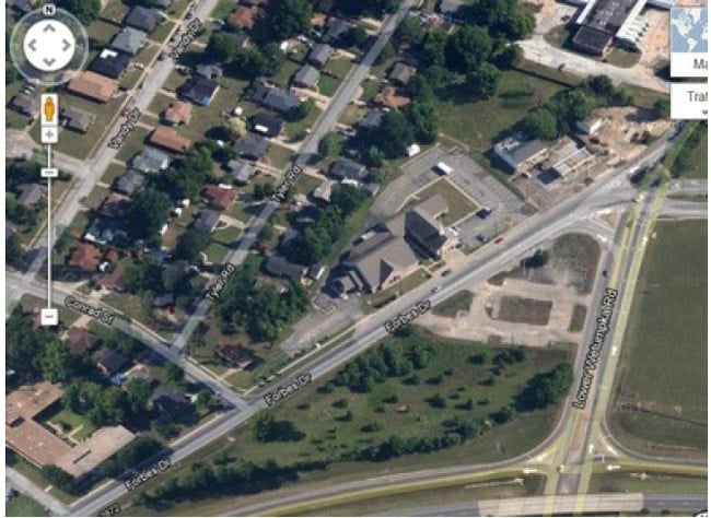
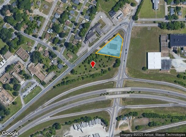
3565 Lower Wetumpka Rd, Montgomery, AL 36110
NEARBY LISTINGS FOR SALE OR LEASE
Property Detail
3565 Lower Wetumpka Rd
Montgomery, AL
Forbes Dr Comm Plat 1
04-09-29-2-019-002.000
0409292019002000
Conveniencestore
Montgomery
X
Alabama
01101C0091J
a
2025
1.19 AC
2025
North Montgomery
005102
Montgomery
3,024 SF
DEMOGRAPHICS near 3565 Lower Wetumpka Rd
1 Mile
3 Mile
5 Mile
2024 Total Population
6,504
20,246
62,726
2029 Population
6,446
20,083
62,105
Pop Growth 2024-2029
(0.89%)
(0.81%)
(0.99%)
Average Age
38
38
38
2024 Total Households
2,581
7,903
24,907
HH Growth 2024-2029
(0.97%)
(0.92%)
(0.87%)
Median Household Inc
$43,556
$40,422
$42,535
Avg Household Size
2.40
2.40
2.20
2024 Avg HH Vehicles
2.00
2.00
2.00
Median Home Value
$60,018
$76,172
$109,279
Median Year Built
1971
1964
1966
Nearby Places
Map Layers
Map Styles
 Street
 Aerial
- Restaurants
- Banks
- Shops
- Fitness
- Groceries
PUBLIC TRANSPORTATION
AIRPORT
Montgomery Regional (Dannelly Field)
DRIVE
WALK
Distance
Montgomery Regional (Dannelly Field)
17 min
12.9 mi
Freight Ports
Port of Mobile
DRIVE
WALK
Distance
Port of Mobile
188 min
172.0 mi
Nearby Properties
Address
Land Use
TOTAL SIZE
Lot Size
Zoning
Address
Land Use
TOTAL SIZE
Lot Size
Zoning
427,546 SF
37.68 AC
M-1
Address
Land Use
TOTAL SIZE
Lot Size
Zoning
122,119 SF
21 AC
R-75-S
Address
Land Use
TOTAL SIZE
Lot Size
Zoning
3,221 SF
14.41 AC
R-65-M
Address
Land Use
TOTAL SIZE
Lot Size
Zoning
96,168 SF
95.16 AC
INST
Address
Land Use
TOTAL SIZE
Lot Size
Zoning
67,643 SF
12.82 AC
M-1
Address
Land Use
TOTAL SIZE
Lot Size
Zoning
1,750 SF
14.61 AC
Address
Land Use
TOTAL SIZE
Lot Size
Zoning
79,846 SF
14.54 AC
Address
Land Use
TOTAL SIZE
Lot Size
Zoning
1,910 SF
11.09 AC
R-65-M
Address
Land Use
TOTAL SIZE
Lot Size
Zoning
1,665 SF
6.80 AC
R-65-M
Address
Land Use
TOTAL SIZE
Lot Size
Zoning
12,891 SF
35.50 AC
M-1
Address
Land Use
TOTAL SIZE
Lot Size
Zoning
64,837 SF
8.30 AC
INST
Address
Land Use
TOTAL SIZE
Lot Size
Zoning
74,046 SF
9.40 AC
INST
Address
Land Use
TOTAL SIZE
Lot Size
Zoning
286 SF
38.40 AC
M-1
Address
Land Use
TOTAL SIZE
Lot Size
Zoning
30,752 SF
1.13 AC
R-100
Address
Land Use
TOTAL SIZE
Lot Size
Zoning
53,415 SF
5.50 AC
R-65-S
Address
Land Use
TOTAL SIZE
Lot Size
Zoning
42,437 SF
4.90 AC
B-2
Address
Land Use
TOTAL SIZE
Lot Size
Zoning
121,567 SF
14.48 AC
M-3
Address
Land Use
TOTAL SIZE
Lot Size
Zoning
48,674 SF
11.66 AC
B-5
Address
Land Use
TOTAL SIZE
Lot Size
Zoning
1,745 SF
24.84 AC
INST
Address
Land Use
TOTAL SIZE
Lot Size
Zoning
190,254 SF
23 AC
M-3
Address
Land Use
TOTAL SIZE
Lot Size
Zoning
84,806 SF
13.38 AC
M-3
Address
Land Use
TOTAL SIZE
Lot Size
Zoning
59,612 SF
6.84 AC
INST
Address
Land Use
TOTAL SIZE
Lot Size
Zoning
79,200 SF
8.40 AC
M-1
Address
Land Use
TOTAL SIZE
Lot Size
Zoning
52,302 SF
10.41 AC
B-2
Address
Land Use
TOTAL SIZE
Lot Size
Zoning
1,538 SF
4.70 AC
B-2
Address
Land Use
TOTAL SIZE
Lot Size
Zoning
27,493 SF
26.40 AC
AGR-1
Address
Land Use
TOTAL SIZE
Lot Size
Zoning
22,143 SF
4.92 AC
M-1
Address
Land Use
TOTAL SIZE
Lot Size
Zoning
37,415 SF
6.11 AC
M-3
Address
Land Use
TOTAL SIZE
Lot Size
Zoning
1,586 SF
13.30 AC
M-3
Address
Land Use
TOTAL SIZE
Lot Size
Zoning
53,034 SF
4.42 AC
M-1
The World's #1 Commercial Real Estate Marketplace
Connect with us
© 2026 CoStar Group
The information above has been obtained from sources believed reliable. While we do not doubt its accuracy we have not verified it and make no guarantee, warranty or representation about it. It is your responsibility to independently confirm its accuracy and completeness. Any projections, opinions, assumptions, or estimates used are for example only and do not represent the current or future performance of the property. The value of this transaction to you depends on tax and other factors which should be evaluated by your tax, financial, and legal advisors. You and your advisors should conduct a careful, independent investigation of the property to determine to your satisfaction the suitability of the property for your needs.