Property Record
3565 N Valley Pike, Rockingham, VA 22802
NEARBY LISTINGS FOR SALE OR LEASE
-
-
View all Rockingham listings for sale on LoopNet.com
Property Detail
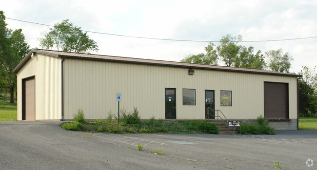
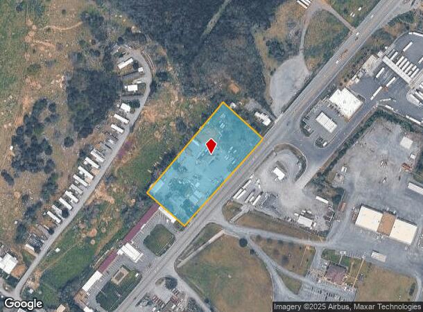
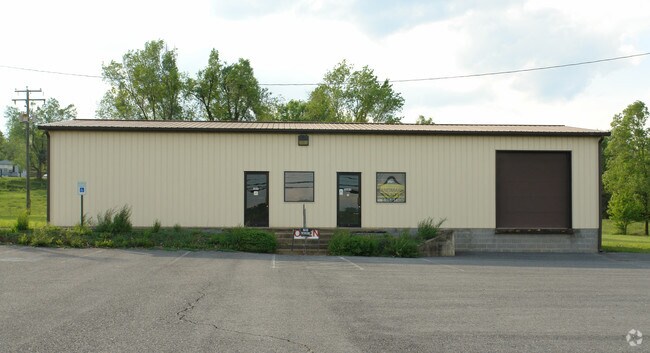
3565 N Valley Pike
95C-8-B-1-L16A
Valley Pike
Storebuilding
VALLEY PIKE
X
Rockingham
51165C0402D
Virginia
2025
2.76 AC
2025
Staunton & Harrisonburg
010500
Other Market Areas
2,295 SF
Harrisonburg, VA
DEMOGRAPHICS near 3565 N Valley Pike
1 Mile
3 Mile
5 Mile
2024 Total Population
1,613
14,553
51,456
2029 Population
1,682
14,407
50,998
Pop Growth 2024-2029
+ 4.28%
(1.00%)
(0.89%)
Average Age
36
36
33
2024 Total Households
611
5,391
17,143
HH Growth 2024-2029
+ 4.26%
(1.28%)
(1.02%)
Median Household Inc
$46,875
$55,112
$53,617
Avg Household Size
2.60
2.60
2.50
2024 Avg HH Vehicles
2.00
2.00
2.00
Median Home Value
$78,813
$205,259
$257,945
Median Year Built
1978
1984
1986
Nearby Places
Map Layers
Map Styles
 Street
 Aerial
- Restaurants
- Banks
- Shops
- Fitness
- Groceries
PUBLIC TRANSPORTATION
AIRPORT
Charlottesville-Albemarle
DRIVE
WALK
Distance
Charlottesville-Albemarle
71 min
49.9 mi
Nearby Properties
Address
Land Use
TOTAL SIZE
Lot Size
Zoning
Address
Land Use
TOTAL SIZE
Lot Size
Zoning
219,561 SF
55.38 AC
GENERAL IN
Address
Land Use
TOTAL SIZE
Lot Size
Zoning
95,500 SF
12.96 AC
GENERAL IN
Address
Land Use
TOTAL SIZE
Lot Size
Zoning
420 SF
88 AC
MULTI DWEL
Address
Land Use
TOTAL SIZE
Lot Size
Zoning
138.58 AC
I1
Address
Land Use
TOTAL SIZE
Lot Size
Zoning
12,276 SF
120 AC
MULTI DWEL
Address
Land Use
TOTAL SIZE
Lot Size
Zoning
4,112 SF
16.16 AC
MULTI DWEL
Address
Land Use
TOTAL SIZE
Lot Size
Zoning
120 AC
MULTI DWEL
Address
Land Use
TOTAL SIZE
Lot Size
Zoning
7,590 SF
81.38 AC
I1
Address
Land Use
TOTAL SIZE
Lot Size
Zoning
16,674 SF
108 AC
MULTI DWEL
Address
Land Use
TOTAL SIZE
Lot Size
Zoning
114,789 SF
150 AC
MULTI DWEL
Address
Land Use
TOTAL SIZE
Lot Size
Zoning
79,698 SF
36.51 AC
GENERAL IN
Address
Land Use
TOTAL SIZE
Lot Size
Zoning
6,612 SF
120 AC
MULTI DWEL
Address
Land Use
TOTAL SIZE
Lot Size
Zoning
46,950 SF
5.88 AC
COMMERCIAL
Address
Land Use
TOTAL SIZE
Lot Size
Zoning
15 AC
GENERAL IN
Address
Land Use
TOTAL SIZE
Lot Size
Zoning
24.72 AC
I1
Address
Land Use
TOTAL SIZE
Lot Size
Zoning
4,685 SF
45.22 AC
B1
Address
Land Use
TOTAL SIZE
Lot Size
Zoning
13,200 SF
15 AC
RESIDENTIA
Address
Land Use
TOTAL SIZE
Lot Size
Zoning
25,211 SF
5 AC
GENERAL IN
Address
Land Use
TOTAL SIZE
Lot Size
Zoning
33,457 SF
3.24 AC
GENERAL IN
Address
Land Use
TOTAL SIZE
Lot Size
Zoning
41,758 SF
7.55 AC
GENERAL IN
Address
Land Use
TOTAL SIZE
Lot Size
Zoning
3,600 SF
66 AC
PLANNED UN
Address
Land Use
TOTAL SIZE
Lot Size
Zoning
69,840 SF
10.16 AC
GENERAL IN
Address
Land Use
TOTAL SIZE
Lot Size
Zoning
90,000 SF
1.82 AC
GENERAL IN
Address
Land Use
TOTAL SIZE
Lot Size
Zoning
90,780 SF
10.61 AC
GENERAL IN
Address
Land Use
TOTAL SIZE
Lot Size
Zoning
9,252 SF
12.08 AC
B1
Address
Land Use
TOTAL SIZE
Lot Size
Zoning
37,331 SF
3.82 AC
GENERAL BU
Address
Land Use
TOTAL SIZE
Lot Size
Zoning
5,100 SF
8.02 AC
GENERAL IN
Address
Land Use
TOTAL SIZE
Lot Size
Zoning
31,106 SF
1.34 AC
RESIDENTIA
Address
Land Use
TOTAL SIZE
Lot Size
Zoning
37,459 SF
12.34 AC
I1
Address
Land Use
TOTAL SIZE
Lot Size
Zoning
49.56 AC
A2
The World's #1 Commercial Real Estate Marketplace
Connect with us
© 2026 CoStar Group
The information above has been obtained from sources believed reliable. While we do not doubt its accuracy we have not verified it and make no guarantee, warranty or representation about it. It is your responsibility to independently confirm its accuracy and completeness. Any projections, opinions, assumptions, or estimates used are for example only and do not represent the current or future performance of the property. The value of this transaction to you depends on tax and other factors which should be evaluated by your tax, financial, and legal advisors. You and your advisors should conduct a careful, independent investigation of the property to determine to your satisfaction the suitability of the property for your needs.