Property Record
3565 Route 611, Stroudsburg, PA 18360
NEARBY LISTINGS FOR SALE OR LEASE
-
-
View all Stroudsburg listings for lease on LoopNet.com
Property Detail
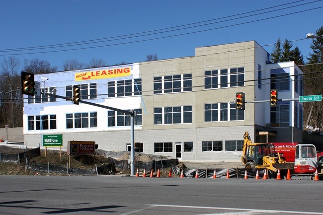
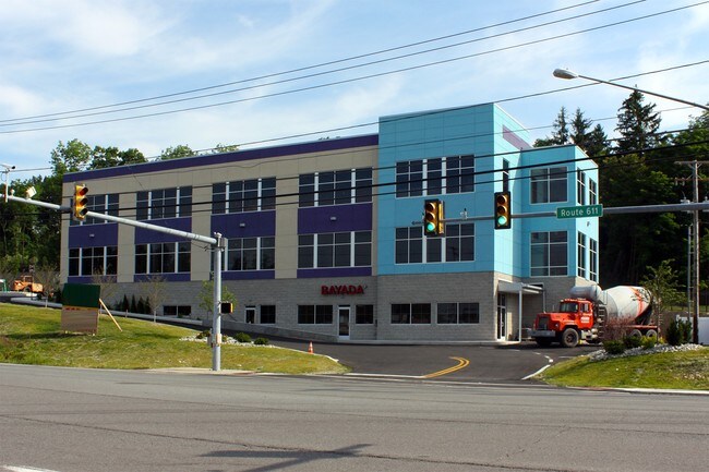
3565 Route 611
Medicalbuilding
Monroe
X
Pennsylvania
42089C0269E
3.16 AC
2025
Monroe County
2025
Philadelphia
301101
East Stroudsburg, PA
32,166 SF
17.17.1.3
DEMOGRAPHICS near 3565 Route 611
1 Mile
3 Mile
5 Mile
2024 Total Population
1,849
16,561
45,039
2029 Population
1,859
16,608
44,625
Pop Growth 2024-2029
+ 0.54%
+ 0.28%
(0.92%)
Average Age
44
44
42
2024 Total Households
706
6,177
16,845
HH Growth 2024-2029
+ 0.57%
+ 0.47%
(0.80%)
Median Household Inc
$78,214
$84,447
$76,454
Avg Household Size
2.60
2.60
2.50
2024 Avg HH Vehicles
2.00
2.00
2.00
Median Home Value
$265,098
$251,094
$241,048
Median Year Built
1984
1985
1981
Nearby Places
Map Layers
Map Styles
 Street
 Aerial
- Restaurants
- Banks
- Shops
- Fitness
- Groceries
PUBLIC TRANSPORTATION
AIRPORT
Lehigh Valley International
DRIVE
WALK
Distance
Lehigh Valley International
45 min
29.7 mi
Freight Ports
Maher Terminal
DRIVE
WALK
Distance
Maher Terminal
95 min
75.1 mi
SALE & LEASE HISTORY
LISTING DATE
SALE/LEASE

Sep 25, 2016
For Lease
Feb 13, 2021
For Lease
Nearby Properties
Address
Land Use
TOTAL SIZE
Lot Size
Zoning
Address
Land Use
TOTAL SIZE
Lot Size
Zoning
382,084 SF
43.31 AC
C-2
Address
Land Use
TOTAL SIZE
Lot Size
Zoning
265,064 SF
107.97 AC
R-1
Address
Land Use
TOTAL SIZE
Lot Size
Zoning
96,316 SF
34.38 AC
C-2
Address
Land Use
TOTAL SIZE
Lot Size
Zoning
85,940 SF
16.19 AC
C-2
Address
Land Use
TOTAL SIZE
Lot Size
Zoning
174,532 SF
56.85 AC
R-2
Address
Land Use
TOTAL SIZE
Lot Size
Zoning
104,753 SF
24 AC
C-2
Address
Land Use
TOTAL SIZE
Lot Size
Zoning
57,088 SF
58.47 AC
C
Address
Land Use
TOTAL SIZE
Lot Size
Zoning
70,939 SF
2.33 AC
C-2
Address
Land Use
TOTAL SIZE
Lot Size
Zoning
13,050 SF
5.96 AC
C-2
Address
Land Use
TOTAL SIZE
Lot Size
Zoning
49,848 SF
5.15 AC
C-2
Address
Land Use
TOTAL SIZE
Lot Size
Zoning
468,747 SF
Address
Land Use
TOTAL SIZE
Lot Size
Zoning
68,039 SF
5.49 AC
R-1
Address
Land Use
TOTAL SIZE
Lot Size
Zoning
124,559 SF
8.53 AC
R-1
Address
Land Use
TOTAL SIZE
Lot Size
Zoning
115,422 SF
9.27 AC
R-1
Address
Land Use
TOTAL SIZE
Lot Size
Zoning
39,879 SF
2.91 AC
C-2
Address
Land Use
TOTAL SIZE
Lot Size
Zoning
39,635 SF
4.78 AC
C-2
Address
Land Use
TOTAL SIZE
Lot Size
Zoning
53,580 SF
2.32 AC
C-2
Address
Land Use
TOTAL SIZE
Lot Size
Zoning
10,988 SF
10 AC
R1
Address
Land Use
TOTAL SIZE
Lot Size
Zoning
49,255 SF
2.89 AC
C-2
Address
Land Use
TOTAL SIZE
Lot Size
Zoning
36,626 SF
10.26 AC
R1
Address
Land Use
TOTAL SIZE
Lot Size
Zoning
27,360 SF
4.52 AC
C-2
Address
Land Use
TOTAL SIZE
Lot Size
Zoning
28,225 SF
1.36 AC
R-1
Address
Land Use
TOTAL SIZE
Lot Size
Zoning
63,300 SF
4.54 AC
C-2
Address
Land Use
TOTAL SIZE
Lot Size
Zoning
19,872 SF
5.22 AC
C-2
Address
Land Use
TOTAL SIZE
Lot Size
Zoning
35,950 SF
5.39 AC
C-2
Address
Land Use
TOTAL SIZE
Lot Size
Zoning
53,505 SF
Address
Land Use
TOTAL SIZE
Lot Size
Zoning
31,836 SF
3.01 AC
R-1
Address
Land Use
TOTAL SIZE
Lot Size
Zoning
42,825 SF
1 AC
Address
Land Use
TOTAL SIZE
Lot Size
Zoning
19,118 SF
5.30 AC
C-2
The World's #1 Commercial Real Estate Marketplace
Connect with us
© 2025 CoStar Group
The information above has been obtained from sources believed reliable. While we do not doubt its accuracy we have not verified it and make no guarantee, warranty or representation about it. It is your responsibility to independently confirm its accuracy and completeness. Any projections, opinions, assumptions, or estimates used are for example only and do not represent the current or future performance of the property. The value of this transaction to you depends on tax and other factors which should be evaluated by your tax, financial, and legal advisors. You and your advisors should conduct a careful, independent investigation of the property to determine to your satisfaction the suitability of the property for your needs.