Property Record
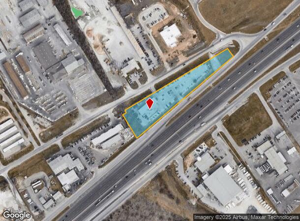
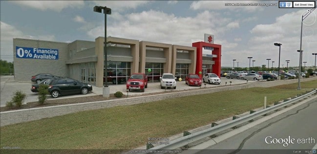
3566 S Interstate 35 S, New Braunfels, TX 78132

NEARBY LISTINGS FOR SALE OR LEASE
Property Detail
3566 S Interstate 35 S
San Antonio-New Braunfels, TX
Point (The)
55-0485-0001-00
POINT (THE), BLOCK 1, LOT 1
Commercialnec
Comal
X
Texas
48091C0445F
1
2024
2.42 AC
2025
Comal County
310401
San Antonio
11,400 SF
DEMOGRAPHICS near 3566 S Interstate 35 S
1 Mile
3 Mile
5 Mile
2024 Total Population
4,264
44,758
89,350
2029 Population
5,828
59,543
117,011
Pop Growth 2024-2029
+ 36.68%
+ 33.03%
+ 30.96%
Average Age
35
37
38
2024 Total Households
1,504
16,614
33,126
HH Growth 2024-2029
+ 36.30%
+ 33.21%
+ 31.50%
Median Household Inc
$72,393
$81,137
$83,852
Avg Household Size
2.80
2.60
2.60
2024 Avg HH Vehicles
2.00
2.00
2.00
Median Home Value
$256,187
$272,512
$284,273
Median Year Built
2002
2002
2001
Nearby Places
Map Layers
Map Styles
 Street
 Aerial
- Restaurants
- Banks
- Shops
- Fitness
- Groceries
PUBLIC TRANSPORTATION
AIRPORT
San Antonio International
DRIVE
WALK
Distance
San Antonio International
28 min
23.3 mi
Freight Ports
Calhoun Port
DRIVE
WALK
Distance
Calhoun Port
175 min
147.5 mi
Nearby Properties
Address
Land Use
TOTAL SIZE
Lot Size
Zoning
Address
Land Use
TOTAL SIZE
Lot Size
Zoning
234,823 SF
72.17 AC
Address
Land Use
TOTAL SIZE
Lot Size
Zoning
433,083 SF
16.24 AC
Address
Land Use
TOTAL SIZE
Lot Size
Zoning
1.80 AC
Address
Land Use
TOTAL SIZE
Lot Size
Zoning
170,266 SF
16.78 AC
Address
Land Use
TOTAL SIZE
Lot Size
Zoning
Address
Land Use
TOTAL SIZE
Lot Size
Zoning
215,244 SF
11.38 AC
Address
Land Use
TOTAL SIZE
Lot Size
Zoning
397,600 SF
25.95 AC
Address
Land Use
TOTAL SIZE
Lot Size
Zoning
188,600 SF
4.61 AC
Address
Land Use
TOTAL SIZE
Lot Size
Zoning
132,319 SF
8.80 AC
Address
Land Use
TOTAL SIZE
Lot Size
Zoning
97,200 SF
12.87 AC
Address
Land Use
TOTAL SIZE
Lot Size
Zoning
198,793 SF
9.38 AC
Address
Land Use
TOTAL SIZE
Lot Size
Zoning
130,210 SF
13.57 AC
Address
Land Use
TOTAL SIZE
Lot Size
Zoning
205,071 SF
23.66 AC
Address
Land Use
TOTAL SIZE
Lot Size
Zoning
92,822 SF
4.94 AC
Address
Land Use
TOTAL SIZE
Lot Size
Zoning
67,722 SF
6.88 AC
Address
Land Use
TOTAL SIZE
Lot Size
Zoning
66,336 SF
7.90 AC
Address
Land Use
TOTAL SIZE
Lot Size
Zoning
156,335 SF
9.94 AC
Address
Land Use
TOTAL SIZE
Lot Size
Zoning
102,000 SF
8.26 AC
Address
Land Use
TOTAL SIZE
Lot Size
Zoning
36,904 SF
16.71 AC
Address
Land Use
TOTAL SIZE
Lot Size
Zoning
Address
Land Use
TOTAL SIZE
Lot Size
Zoning
60,296 SF
5.73 AC
Address
Land Use
TOTAL SIZE
Lot Size
Zoning
52,898 SF
39.39 AC
Address
Land Use
TOTAL SIZE
Lot Size
Zoning
3,372 SF
76.62 AC
Address
Land Use
TOTAL SIZE
Lot Size
Zoning
969.31 AC
Address
Land Use
TOTAL SIZE
Lot Size
Zoning
79,573 SF
4 AC
Address
Land Use
TOTAL SIZE
Lot Size
Zoning
55,492 SF
6.13 AC
Address
Land Use
TOTAL SIZE
Lot Size
Zoning
89,582 SF
9.04 AC
Address
Land Use
TOTAL SIZE
Lot Size
Zoning
137,524 SF
15.34 AC
Address
Land Use
TOTAL SIZE
Lot Size
Zoning
77,487 SF
9 AC
Address
Land Use
TOTAL SIZE
Lot Size
Zoning
92,496 SF
6.91 AC
The World's #1 Commercial Real Estate Marketplace
Connect with us
© 2025 CoStar Group
The information above has been obtained from sources believed reliable. While we do not doubt its accuracy we have not verified it and make no guarantee, warranty or representation about it. It is your responsibility to independently confirm its accuracy and completeness. Any projections, opinions, assumptions, or estimates used are for example only and do not represent the current or future performance of the property. The value of this transaction to you depends on tax and other factors which should be evaluated by your tax, financial, and legal advisors. You and your advisors should conduct a careful, independent investigation of the property to determine to your satisfaction the suitability of the property for your needs.