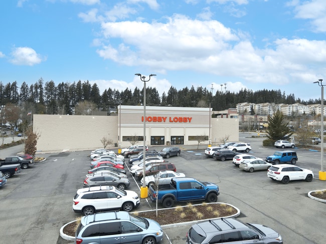
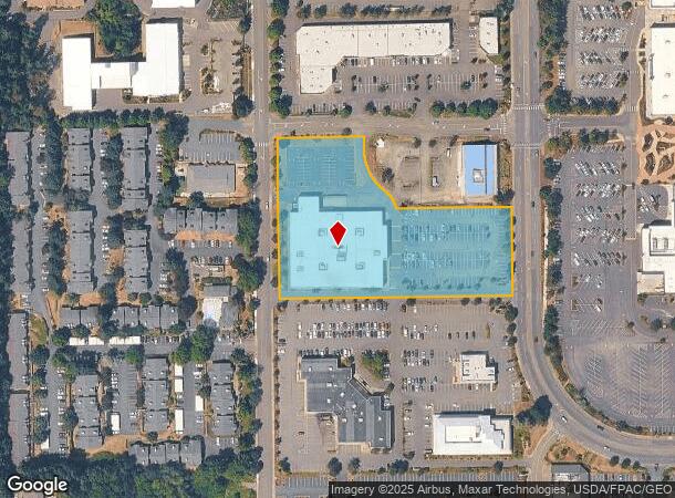
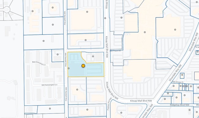
Property Record
3567 Nw Randall Way, Silverdale, WA 98383

NEARBY LISTINGS FOR SALE OR LEASE
Property Detail
3567 Nw Randall Way
Bremerton-Silverdale, WA
Replat Of Clear Creek Plaza
5065-000-001-01-09
LOTS 1, 3, 4, 5 AND 6, REPLAT OF CLEAR CREEK PLAZA, ACCORDING TO THE PLAT THEREOF RECORDED IN VOLUME 25 OF PLATS, PAGES 135 AND 136, RECORDS OF KITSAP COUNTY, WASHINGTON.
Storebuilding
Kitsap
X
Washington
53031C1340C
1,3-5
2025
3.63 AC
2026
Silverdale
091201
Bremerton/Silverdale
42,480 SF
DEMOGRAPHICS near 3567 Nw Randall Way
1 Mile
3 Mile
5 Mile
2024 Total Population
3,840
38,809
76,424
2029 Population
3,866
39,275
77,140
Pop Growth 2024-2029
+ 0.68%
+ 1.20%
+ 0.94%
Average Age
42
39
39
2024 Total Households
1,815
14,317
27,963
HH Growth 2024-2029
+ 0.61%
+ 1.13%
+ 0.92%
Median Household Inc
$64,818
$92,717
$89,471
Avg Household Size
2.10
2.60
2.60
2024 Avg HH Vehicles
2.00
2.00
2.00
Median Home Value
$468,202
$462,746
$459,395
Median Year Built
1990
1990
1988
Nearby Places
Map Layers
Map Styles
 Street
 Aerial
- Restaurants
- Banks
- Shops
- Fitness
- Groceries
PUBLIC TRANSPORTATION
AIRPORT
Seattle Paine Field International
DRIVE
WALK
Distance
Seattle Paine Field International
79 min
34.6 mi
SALE & LEASE HISTORY
LISTING DATE
SALE/LEASE

Mar 20, 2024
For Sale
Mar 20, 2023
For Sale
Nearby Properties
Address
Land Use
TOTAL SIZE
Lot Size
Zoning
Address
Land Use
TOTAL SIZE
Lot Size
Zoning
382,574 SF
33.22 AC
RC
Address
Land Use
TOTAL SIZE
Lot Size
Zoning
24.22 AC
C
Address
Land Use
TOTAL SIZE
Lot Size
Zoning
279,313 SF
14.59 AC
UH
Address
Land Use
TOTAL SIZE
Lot Size
Zoning
230,959 SF
11.33 AC
RC
Address
Land Use
TOTAL SIZE
Lot Size
Zoning
202,109 SF
11.41 AC
UH
Address
Land Use
TOTAL SIZE
Lot Size
Zoning
230,257 SF
28.58 AC
C
Address
Land Use
TOTAL SIZE
Lot Size
Zoning
196,395 SF
12.56 AC
UH
Address
Land Use
TOTAL SIZE
Lot Size
Zoning
200,242 SF
11.77 AC
UH
Address
Land Use
TOTAL SIZE
Lot Size
Zoning
1,266 SF
7.18 AC
C
Address
Land Use
TOTAL SIZE
Lot Size
Zoning
131,452 SF
9.51 AC
UM
Address
Land Use
TOTAL SIZE
Lot Size
Zoning
163,784 SF
10.31 AC
UH
Address
Land Use
TOTAL SIZE
Lot Size
Zoning
6.46 AC
C
Address
Land Use
TOTAL SIZE
Lot Size
Zoning
107,223 SF
12.76 AC
UM
Address
Land Use
TOTAL SIZE
Lot Size
Zoning
132,092 SF
16.36 AC
UM
Address
Land Use
TOTAL SIZE
Lot Size
Zoning
108,562 SF
8.89 AC
UL
Address
Land Use
TOTAL SIZE
Lot Size
Zoning
112,755 SF
5.12 AC
UH
Address
Land Use
TOTAL SIZE
Lot Size
Zoning
289,455 SF
12.21 AC
RC
Address
Land Use
TOTAL SIZE
Lot Size
Zoning
107,656 SF
6.22 AC
UH
Address
Land Use
TOTAL SIZE
Lot Size
Zoning
108,384 SF
8.55 AC
UL
Address
Land Use
TOTAL SIZE
Lot Size
Zoning
124,872 SF
4.67 AC
RC
Address
Land Use
TOTAL SIZE
Lot Size
Zoning
91,300 SF
4.66 AC
RC
Address
Land Use
TOTAL SIZE
Lot Size
Zoning
109,790 SF
10.07 AC
UL
Address
Land Use
TOTAL SIZE
Lot Size
Zoning
138,000 SF
6.80 AC
RC
Address
Land Use
TOTAL SIZE
Lot Size
Zoning
70,452 SF
4.49 AC
RC
Address
Land Use
TOTAL SIZE
Lot Size
Zoning
59,220 SF
6.37 AC
RC
Address
Land Use
TOTAL SIZE
Lot Size
Zoning
1.71 AC
RC
Address
Land Use
TOTAL SIZE
Lot Size
Zoning
103,689 SF
8.48 AC
RC
Address
Land Use
TOTAL SIZE
Lot Size
Zoning
112,500 SF
4.76 AC
RC
Address
Land Use
TOTAL SIZE
Lot Size
Zoning
106,087 SF
9.40 AC
UM
Address
Land Use
TOTAL SIZE
Lot Size
Zoning
154,571 SF
13.81 AC
RC
The World's #1 Commercial Real Estate Marketplace
Connect with us
© 2025 CoStar Group
The information above has been obtained from sources believed reliable. While we do not doubt its accuracy we have not verified it and make no guarantee, warranty or representation about it. It is your responsibility to independently confirm its accuracy and completeness. Any projections, opinions, assumptions, or estimates used are for example only and do not represent the current or future performance of the property. The value of this transaction to you depends on tax and other factors which should be evaluated by your tax, financial, and legal advisors. You and your advisors should conduct a careful, independent investigation of the property to determine to your satisfaction the suitability of the property for your needs.