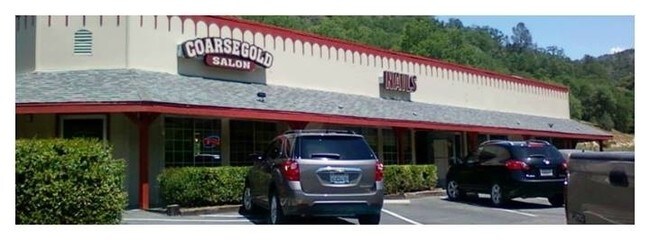
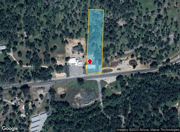
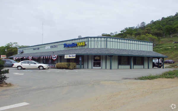
Property Record
35686 Highway 41, Coarsegold, CA 93614

NEARBY LISTINGS FOR SALE OR LEASE
-
-
View all Coarsegold listings for sale on LoopNet.com
Property Detail
35686 Highway 41
Madera, CA
Yosemite Lakes Park
054-070-021
SEC 4 T8S R21E
Storebuilding
Madera
X
California
06039C0495E
1763
2024
2.40 AC
2025
Outlying Madera County
000111
Fresno
3,950 SF
DEMOGRAPHICS near 35686 Highway 41
1 Mile
3 Mile
5 Mile
2024 Total Population
152
2,328
9,494
2029 Population
163
2,460
10,109
Pop Growth 2024-2029
+ 7.24%
+ 5.67%
+ 6.48%
Average Age
50
48
46
2024 Total Households
66
963
3,807
HH Growth 2024-2029
+ 6.06%
+ 5.30%
+ 6.15%
Median Household Inc
$65,000
$63,641
$64,091
Avg Household Size
2.30
2.40
2.40
2024 Avg HH Vehicles
2.00
2.00
2.00
Median Home Value
$450,000
$387,292
$357,636
Median Year Built
1992
1994
1988
Nearby Places
Map Layers
Map Styles
 Street
 Aerial
- Restaurants
- Banks
- Shops
- Fitness
- Groceries
PUBLIC TRANSPORTATION
AIRPORT
Fresno Yosemite International
DRIVE
WALK
Distance
Fresno Yosemite International
57 min
40.2 mi
Nearby Properties
Address
Land Use
TOTAL SIZE
Lot Size
Zoning
Address
Land Use
TOTAL SIZE
Lot Size
Zoning
59.77 AC
RRS-2 1/2
Address
Land Use
TOTAL SIZE
Lot Size
Zoning
1,608 SF
33.01 AC
ARF
Address
Land Use
TOTAL SIZE
Lot Size
Zoning
7,884 SF
5.78 AC
RRS-2 1/2
Address
Land Use
TOTAL SIZE
Lot Size
Zoning
825 SF
5.35 AC
CRM
Address
Land Use
TOTAL SIZE
Lot Size
Zoning
2,032 SF
38.56 AC
ARE-40
Address
Land Use
TOTAL SIZE
Lot Size
Zoning
5,473 SF
735.28 AC
ARE-40
Address
Land Use
TOTAL SIZE
Lot Size
Zoning
2,068 SF
273.78 AC
ARE-40
Address
Land Use
TOTAL SIZE
Lot Size
Zoning
6,180 SF
1.99 AC
CRM
Address
Land Use
TOTAL SIZE
Lot Size
Zoning
38.52 AC
OS
Address
Land Use
TOTAL SIZE
Lot Size
Zoning
13,051 SF
7.05 AC
RRS-2 1/2
Address
Land Use
TOTAL SIZE
Lot Size
Zoning
1,158 SF
61.20 AC
ARE-40
Address
Land Use
TOTAL SIZE
Lot Size
Zoning
1,800 SF
1.12 AC
CRM
Address
Land Use
TOTAL SIZE
Lot Size
Zoning
3,817 SF
160 AC
ARE-160
Address
Land Use
TOTAL SIZE
Lot Size
Zoning
20.65 AC
RMS
Address
Land Use
TOTAL SIZE
Lot Size
Zoning
4,507 SF
39.69 AC
RM
Address
Land Use
TOTAL SIZE
Lot Size
Zoning
3,444 SF
2.10 AC
CRM
Address
Land Use
TOTAL SIZE
Lot Size
Zoning
3,038 SF
36.02 AC
RRS-5
Address
Land Use
TOTAL SIZE
Lot Size
Zoning
672 SF
1.99 AC
ARF
Address
Land Use
TOTAL SIZE
Lot Size
Zoning
1,667 SF
10.72 AC
Address
Land Use
TOTAL SIZE
Lot Size
Zoning
3,000 SF
0.70 AC
RRS-2 1/2
Address
Land Use
TOTAL SIZE
Lot Size
Zoning
2,108 SF
2.50 AC
ARF
Address
Land Use
TOTAL SIZE
Lot Size
Zoning
2,898 SF
2.10 AC
RRS-2
Address
Land Use
TOTAL SIZE
Lot Size
Zoning
2,916 SF
2.25 AC
RRS-2
Address
Land Use
TOTAL SIZE
Lot Size
Zoning
3,417 SF
37.14 AC
RMS
Address
Land Use
TOTAL SIZE
Lot Size
Zoning
2,472 SF
11.61 AC
ARF
Address
Land Use
TOTAL SIZE
Lot Size
Zoning
4,568 SF
3.79 AC
ARF
Address
Land Use
TOTAL SIZE
Lot Size
Zoning
7,838 SF
53.62 AC
CRM
Address
Land Use
TOTAL SIZE
Lot Size
Zoning
2,815 SF
35.63 AC
ARF
Address
Land Use
TOTAL SIZE
Lot Size
Zoning
2,355 SF
40.68 AC
ARE-40
The World's #1 Commercial Real Estate Marketplace
Connect with us
© 2025 CoStar Group
The information above has been obtained from sources believed reliable. While we do not doubt its accuracy we have not verified it and make no guarantee, warranty or representation about it. It is your responsibility to independently confirm its accuracy and completeness. Any projections, opinions, assumptions, or estimates used are for example only and do not represent the current or future performance of the property. The value of this transaction to you depends on tax and other factors which should be evaluated by your tax, financial, and legal advisors. You and your advisors should conduct a careful, independent investigation of the property to determine to your satisfaction the suitability of the property for your needs.