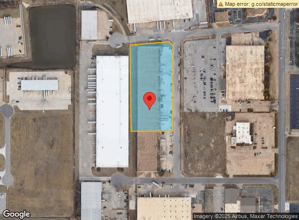
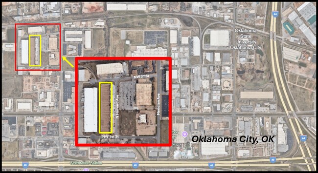
Property Record
397 N Harvard Ave, Oklahoma City, OK 73127

NEARBY LISTINGS FOR SALE OR LEASE
Property Detail
397 N Harvard Ave
Oklahoma City, OK
Metropolitan Ind. Pk N. #2
148591175
METROPOLITAN IND. PK N. #2 000 000 N PT OF LT 1 BLK 3 BEING 562.47FT ON W & 561.04FT ON E
Warehouse
Oklahoma
A
Oklahoma
40109C0280H
1
2023
5.91 AC
2024
West
106913
Oklahoma City
92,130 SF
DEMOGRAPHICS near 397 N Harvard Ave
1 Mile
3 Mile
5 Mile
2024 Total Population
5,083
73,766
210,581
2029 Population
5,273
76,062
218,751
Pop Growth 2024-2029
+ 3.74%
+ 3.11%
+ 3.88%
Average Age
33
35
36
2024 Total Households
1,961
29,140
83,667
HH Growth 2024-2029
+ 3.98%
+ 3.20%
+ 3.86%
Median Household Inc
$29,475
$44,120
$47,068
Avg Household Size
2.50
2.40
2.40
2024 Avg HH Vehicles
1.00
2.00
2.00
Median Home Value
$80,331
$129,349
$138,009
Median Year Built
1967
1964
1963
Nearby Places
Map Layers
Map Styles
 Street
 Aerial
- Restaurants
- Banks
- Shops
- Fitness
- Groceries
PUBLIC TRANSPORTATION
AIRPORT
Will Rogers World
DRIVE
WALK
Distance
Will Rogers World
13 min
5.3 mi
Freight Ports
Port of Shreveport
DRIVE
WALK
Distance
Port of Shreveport
1 min
313.5 mi
SALE & LEASE HISTORY
LISTING DATE
SALE/LEASE

Jan 19, 2018
For Lease
Feb 04, 2024
For Lease
Apr 21, 2025
For Lease
Apr 06, 2020
For Lease
Apr 04, 2017
For Lease
Nearby Properties
Address
Land Use
TOTAL SIZE
Lot Size
Zoning
Address
Land Use
TOTAL SIZE
Lot Size
Zoning
1,976,300 SF
217.95 AC
I-2
Address
Land Use
TOTAL SIZE
Lot Size
Zoning
388,082 SF
34.03 AC
I-2
Address
Land Use
TOTAL SIZE
Lot Size
Zoning
44,519 SF
3.39 AC
SPUD
Address
Land Use
TOTAL SIZE
Lot Size
Zoning
246,774 SF
55.60 AC
PUD
Address
Land Use
TOTAL SIZE
Lot Size
Zoning
195,412 SF
4.42 AC
I-1
Address
Land Use
TOTAL SIZE
Lot Size
Zoning
1,194,497 SF
89.98 AC
I-2
Address
Land Use
TOTAL SIZE
Lot Size
Zoning
259,726 SF
19.94 AC
PUD
Address
Land Use
TOTAL SIZE
Lot Size
Zoning
211,626 SF
12.67 AC
PUD
Address
Land Use
TOTAL SIZE
Lot Size
Zoning
279,224 SF
18.75 AC
PUD
Address
Land Use
TOTAL SIZE
Lot Size
Zoning
181,946 SF
4.42 AC
C-4
Address
Land Use
TOTAL SIZE
Lot Size
Zoning
192,771 SF
11.20 AC
I-3
Address
Land Use
TOTAL SIZE
Lot Size
Zoning
371,946 SF
31.38 AC
I-2
Address
Land Use
TOTAL SIZE
Lot Size
Zoning
336,750 SF
15.53 AC
I-3
Address
Land Use
TOTAL SIZE
Lot Size
Zoning
158,150 SF
15.18 AC
I-2
Address
Land Use
TOTAL SIZE
Lot Size
Zoning
141,204 SF
6.10 AC
I-2
Address
Land Use
TOTAL SIZE
Lot Size
Zoning
246,884 SF
11.64 AC
I-2
Address
Land Use
TOTAL SIZE
Lot Size
Zoning
182,590 SF
11.35 AC
R-4
Address
Land Use
TOTAL SIZE
Lot Size
Zoning
166,850 SF
9.97 AC
I-2
Address
Land Use
TOTAL SIZE
Lot Size
Zoning
110,391 SF
28.91 AC
I-2
Address
Land Use
TOTAL SIZE
Lot Size
Zoning
223,679 SF
40.52 AC
PUD
Address
Land Use
TOTAL SIZE
Lot Size
Zoning
258,262 SF
15.17 AC
Address
Land Use
TOTAL SIZE
Lot Size
Zoning
217,512 SF
8.79 AC
Address
Land Use
TOTAL SIZE
Lot Size
Zoning
83,055 SF
6.25 AC
PUD
Address
Land Use
TOTAL SIZE
Lot Size
Zoning
182,948 SF
10 AC
Address
Land Use
TOTAL SIZE
Lot Size
Zoning
81,491 SF
15 AC
C-3
Address
Land Use
TOTAL SIZE
Lot Size
Zoning
239,654 SF
24.50 AC
PUD
Address
Land Use
TOTAL SIZE
Lot Size
Zoning
217,328 SF
11.52 AC
I-3
Address
Land Use
TOTAL SIZE
Lot Size
Zoning
208,038 SF
8.55 AC
PUD
Address
Land Use
TOTAL SIZE
Lot Size
Zoning
88,098 SF
5.94 AC
C-4
Address
Land Use
TOTAL SIZE
Lot Size
Zoning
65,850 SF
6.25 AC
PUD
The World's #1 Commercial Real Estate Marketplace
Connect with us
© 2025 CoStar Group
The information above has been obtained from sources believed reliable. While we do not doubt its accuracy we have not verified it and make no guarantee, warranty or representation about it. It is your responsibility to independently confirm its accuracy and completeness. Any projections, opinions, assumptions, or estimates used are for example only and do not represent the current or future performance of the property. The value of this transaction to you depends on tax and other factors which should be evaluated by your tax, financial, and legal advisors. You and your advisors should conduct a careful, independent investigation of the property to determine to your satisfaction the suitability of the property for your needs.