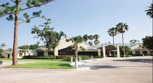
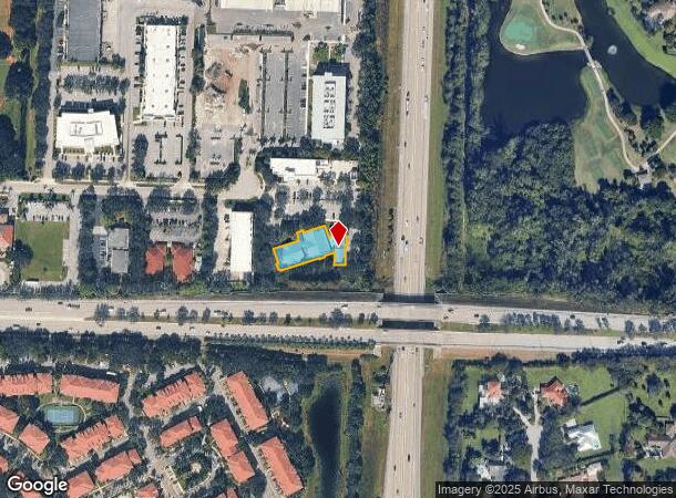
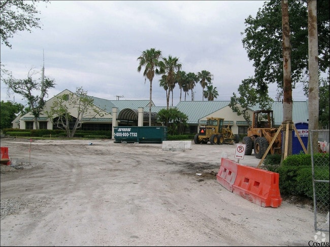
Property Record
357 Hiatt Dr, Palm Beach Gardens, FL 33418

NEARBY LISTINGS FOR SALE OR LEASE
Property Detail
357 Hiatt Dr
West Palm Beach-Boca Raton-Delray Beach, FL
Pga National Commerce Park Pl 2
52-42-42-15-38-000-0042
PGA NATIONAL COMMERCE PARK PL 2 PT OF LT 4 K/A OFFICE BLDG IN OR20265P1504
Officebuilding
Palm Beach
X
Florida
12099C0367F
4
2024
0.43 AC
2025
Palm Bch Cty Outlying
007831
South Florida
12,154 SF
DEMOGRAPHICS near 357 Hiatt Dr
1 Mile
3 Mile
5 Mile
2024 Total Population
5,769
46,661
149,099
2029 Population
5,937
48,285
155,876
Pop Growth 2024-2029
+ 2.91%
+ 3.48%
+ 4.55%
Average Age
53
45
43
2024 Total Households
2,692
19,511
61,229
HH Growth 2024-2029
+ 2.19%
+ 2.93%
+ 4.03%
Median Household Inc
$108,542
$86,263
$75,409
Avg Household Size
2.10
2.30
2.30
2024 Avg HH Vehicles
2.00
2.00
2.00
Median Home Value
$459,623
$393,382
$374,223
Median Year Built
1991
1989
1989
Nearby Places
Map Layers
Map Styles
 Street
 Aerial
- Restaurants
- Banks
- Shops
- Fitness
- Groceries
PUBLIC TRANSPORTATION
COMMUTER RAIL
Mangonia Park (Tri-County Commuter - South Florida Regional Transportation Authority (Tri-Rail))
DRIVE
WALK
Distance
Mangonia Park (Tri-County Commuter - South Florida Regional Transportation Authority (Tri-Rail))
14 min
7.0 mi
AIRPORT
Palm Beach International
DRIVE
WALK
Distance
Palm Beach International
23 min
13.0 mi
Freight Ports
Port of Palm Beach
DRIVE
WALK
Distance
Port of Palm Beach
16 min
7.5 mi
SALE & LEASE HISTORY
LISTING DATE
SALE/LEASE

Sep 25, 2016
For Lease
Jan 20, 2017
For Sale
Apr 05, 2023
For Lease
Apr 04, 2023
For Sale
Nearby Properties
Address
Land Use
TOTAL SIZE
Lot Size
Zoning
Address
Land Use
TOTAL SIZE
Lot Size
Zoning
1,778,741 SF
69.19 AC
CF
Address
Land Use
TOTAL SIZE
Lot Size
Zoning
626,464 SF
2.91 AC
MXD
Address
Land Use
TOTAL SIZE
Lot Size
Zoning
770,163 SF
571.53 AC
CS
Address
Land Use
TOTAL SIZE
Lot Size
Zoning
390,568 SF
38.79 AC
NZ
Address
Land Use
TOTAL SIZE
Lot Size
Zoning
650,167 SF
27.64 AC
PCD
Address
Land Use
TOTAL SIZE
Lot Size
Zoning
697,820 SF
19.21 AC
PCD
Address
Land Use
TOTAL SIZE
Lot Size
Zoning
390,319 SF
44.34 AC
PCD
Address
Land Use
TOTAL SIZE
Lot Size
Zoning
416,171 SF
19.24 AC
R-PUD
Address
Land Use
TOTAL SIZE
Lot Size
Zoning
406,434 SF
40.60 AC
P/I
Address
Land Use
TOTAL SIZE
Lot Size
Zoning
381,665 SF
26.01 AC
PCD
Address
Land Use
TOTAL SIZE
Lot Size
Zoning
155,141 SF
25.97 AC
PCD
Address
Land Use
TOTAL SIZE
Lot Size
Zoning
180,563 SF
54.46 AC
P/I
Address
Land Use
TOTAL SIZE
Lot Size
Zoning
215,592 SF
38.87 AC
RL3
Address
Land Use
TOTAL SIZE
Lot Size
Zoning
118,741 SF
6.21 AC
PCD
Address
Land Use
TOTAL SIZE
Lot Size
Zoning
198,571 SF
6.58 AC
CG1
Address
Land Use
TOTAL SIZE
Lot Size
Zoning
97,179 SF
10.64 AC
MXD
Address
Land Use
TOTAL SIZE
Lot Size
Zoning
259,070 SF
12.95 AC
IL
Address
Land Use
TOTAL SIZE
Lot Size
Zoning
87,936 SF
8.46 AC
PCD
Address
Land Use
TOTAL SIZE
Lot Size
Zoning
182,208 SF
8.03 AC
CG1
Address
Land Use
TOTAL SIZE
Lot Size
Zoning
153,818 SF
17.57 AC
CG1
Address
Land Use
TOTAL SIZE
Lot Size
Zoning
8,976 SF
4.64 AC
MXD
Address
Land Use
TOTAL SIZE
Lot Size
Zoning
116,484 SF
11.52 AC
CG1
Address
Land Use
TOTAL SIZE
Lot Size
Zoning
116,383 SF
7.52 AC
PCD
Address
Land Use
TOTAL SIZE
Lot Size
Zoning
155,328 SF
1.08 AC
CG1
Address
Land Use
TOTAL SIZE
Lot Size
Zoning
90,414 SF
13.18 AC
CG1
Address
Land Use
TOTAL SIZE
Lot Size
Zoning
70,660 SF
3.98 AC
CG
Address
Land Use
TOTAL SIZE
Lot Size
Zoning
256,782 SF
20.05 AC
IG
Address
Land Use
TOTAL SIZE
Lot Size
Zoning
66,810 SF
7.02 AC
PCD
Address
Land Use
TOTAL SIZE
Lot Size
Zoning
216,477 SF
34.50 AC
C2
Address
Land Use
TOTAL SIZE
Lot Size
Zoning
6,132 SF
355.72 AC
PO
The World's #1 Commercial Real Estate Marketplace
Connect with us
© 2026 CoStar Group
The information above has been obtained from sources believed reliable. While we do not doubt its accuracy we have not verified it and make no guarantee, warranty or representation about it. It is your responsibility to independently confirm its accuracy and completeness. Any projections, opinions, assumptions, or estimates used are for example only and do not represent the current or future performance of the property. The value of this transaction to you depends on tax and other factors which should be evaluated by your tax, financial, and legal advisors. You and your advisors should conduct a careful, independent investigation of the property to determine to your satisfaction the suitability of the property for your needs.