Property Record
357 Salmon Brook St, Granby, CT 06035
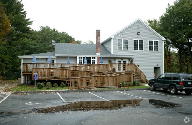

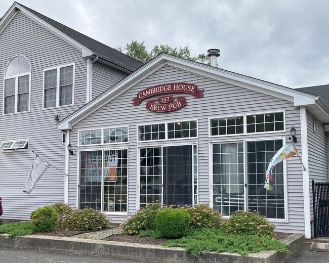
Property Detail
357 Salmon Brook St
GRAN-000042F-000051-000067
Capitol
Commercialbuilding
Connecticut
C2
67
AE The base floodplain where base flood elevations are provided. AE Zones are now used on new format FIRMs instead of A1-A30 Zones.
1.30 AC
2025
Northwest Outlying
2025
Hartford
468102
Hartford-West Hartford-East Hartford, CT
5,160 SF
NEARBY LISTINGS FOR SALE OR LEASE
-
-
View all Granby listings for sale on LoopNet.com
DEMOGRAPHICS near 357 Salmon Brook St
1 mile
3 mile
5 mile
2025 Total Population
2,210
10,105
26,723
2030 Population
2,308
10,411
27,348
Pop Growth 2025-2030
+ 4.43%
+ 3.03%
+ 2.34%
Average Age
44
44
43
2025 Total Households
840
3,995
10,577
HH Growth 2025-2030
+ 4.64%
+ 3.08%
+ 2.36%
Median Household Inc
$104,808
$126,621
$123,223
Avg Household Size
2.50
2.50
2.50
2025 Avg HH Vehicles
2.00
2.00
2.00
Median Home Value
$394,285
$396,811
$396,983
Median Year Built
1974
1974
1974
Nearby Places
Map Layers
Map Styles
 Street
 Aerial
Layers
 Traffic
 Biking
Places
Listings with unknown addresses are not visible on the map
- Restaurants
- Banks
- Shops
- Fitness
- Groceries
PUBLIC TRANSPORTATION
AIRPORT
Bradley International
Drive
Walk
Distance
Bradley International
22 min
8.1 mi
Freight Ports
Port of New Haven
Drive
Walk
Distance
Port of New Haven
75 min
51.5 mi
SALE & LEASE HISTORY
LISTING DATE
SALE/LEASE

Jun 06, 2024
For Sale
Nearby Properties
Address
Land Use
TOTAL SIZE
Lot Size
Zoning
Address
Land Use
TOTAL SIZE
Lot Size
Zoning
1,517 SF
45.69 AC
CC
Address
Land Use
TOTAL SIZE
Lot Size
Zoning
27.95 AC
CC
Address
Land Use
TOTAL SIZE
Lot Size
Zoning
34.66 AC
T1
Address
Land Use
TOTAL SIZE
Lot Size
Zoning
1,576 SF
9.52 AC
T1
Address
Land Use
TOTAL SIZE
Lot Size
Zoning
58,477 SF
14.99 AC
R30
Address
Land Use
TOTAL SIZE
Lot Size
Zoning
49.92 AC
Address
Land Use
TOTAL SIZE
Lot Size
Zoning
61,692 SF
12 AC
R50
Address
Land Use
TOTAL SIZE
Lot Size
Zoning
13.05 AC
C2
Address
Land Use
TOTAL SIZE
Lot Size
Zoning
5.32 AC
ED
Address
Land Use
TOTAL SIZE
Lot Size
Zoning
14.38 AC
CC
Address
Land Use
TOTAL SIZE
Lot Size
Zoning
5.96 AC
CO
Address
Land Use
TOTAL SIZE
Lot Size
Zoning
71,092 SF
6.23 AC
T1
Address
Land Use
TOTAL SIZE
Lot Size
Zoning
54,568 SF
11.74 AC
C2
Address
Land Use
TOTAL SIZE
Lot Size
Zoning
7.40 AC
CE
Address
Land Use
TOTAL SIZE
Lot Size
Zoning
43,094 SF
33.80 AC
R30
Address
Land Use
TOTAL SIZE
Lot Size
Zoning
1,064.60 AC
R2A
Address
Land Use
TOTAL SIZE
Lot Size
Zoning
12.98 AC
I
Address
Land Use
TOTAL SIZE
Lot Size
Zoning
12.98 AC
Address
Land Use
TOTAL SIZE
Lot Size
Zoning
2.70 AC
CO
Address
Land Use
TOTAL SIZE
Lot Size
Zoning
30,936 SF
15.40 AC
A
Address
Land Use
TOTAL SIZE
Lot Size
Zoning
22.23 AC
R2A
Address
Land Use
TOTAL SIZE
Lot Size
Zoning
450.70 AC
A
Address
Land Use
TOTAL SIZE
Lot Size
Zoning
16,543 SF
1.91 AC
R50
Address
Land Use
TOTAL SIZE
Lot Size
Zoning
10,107 SF
1.40 AC
CO
Address
Land Use
TOTAL SIZE
Lot Size
Zoning
24,900 SF
17.30 AC
CP
Address
Land Use
TOTAL SIZE
Lot Size
Zoning
2.89 AC
R30
Address
Land Use
TOTAL SIZE
Lot Size
Zoning
13,991 SF
2.08 AC
R30
Address
Land Use
TOTAL SIZE
Lot Size
Zoning
4.20 AC
CC
Address
Land Use
TOTAL SIZE
Lot Size
Zoning
10,103 SF
215.36 AC
I
Address
Land Use
TOTAL SIZE
Lot Size
Zoning
13,243 SF
3.08 AC
CC
The World's #1 Commercial Real Estate Marketplace
Connect with us
© 2026 CoStar Group
The information above has been obtained from sources believed reliable. While we do not doubt its accuracy we have not verified it and make no guarantee, warranty or representation about it. It is your responsibility to independently confirm its accuracy and completeness. Any projections, opinions, assumptions, or estimates used are for example only and do not represent the current or future performance of the property. The value of this transaction to you depends on tax and other factors which should be evaluated by your tax, financial, and legal advisors. You and your advisors should conduct a careful, independent investigation of the property to determine to your satisfaction the suitability of the property for your needs.