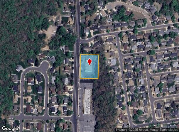
Property Record
357 Spotswood Englishtown Rd, Monroe Township, NJ 08831
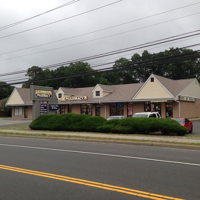
Current Lease Availabilities
General Retail LEASE
$18.00 SF/YR
1,200 - 4,800 SF
NEARBY LISTINGS FOR SALE OR LEASE
-
-
-
-
No Photo
-
-
-
-
View all Monroe Township listings for lease on LoopNet.com
Property Detail
357 Spotswood Englishtown Rd
12-00160-6-00036
1.1020
Storemultistory
Middlesex
X
New Jersey
34023C0144F
36
2024
1.10 AC
2025
Brunswick
008212
Northern New Jersey
7,200 SF
New York-Jersey City-White Plains, NY-NJ
DEMOGRAPHICS near 357 Spotswood Englishtown Rd
1 Mile
3 Mile
5 Mile
2024 Total Population
8,406
52,535
148,468
2029 Population
8,357
52,376
147,895
Pop Growth 2024-2029
(0.58%)
(0.30%)
(0.39%)
Average Age
42
42
43
2024 Total Households
2,726
17,912
53,564
HH Growth 2024-2029
(0.66%)
(0.50%)
(0.51%)
Median Household Inc
$135,942
$122,090
$111,986
Avg Household Size
3.00
2.90
2.70
2024 Avg HH Vehicles
2.00
2.00
2.00
Median Home Value
$453,596
$435,242
$446,418
Median Year Built
1972
1975
1978
Nearby Places
- Restaurants
- Banks
- Shops
- Fitness
- Groceries
PUBLIC TRANSPORTATION
AIRPORT
Trenton Mercer
DRIVE
WALK
Distance
Trenton Mercer
48 min
30.3 mi
Newark Liberty International
DRIVE
WALK
Distance
Newark Liberty International
47 min
33.3 mi
Freight Ports
New York Container Terminal
DRIVE
WALK
Distance
New York Container Terminal
40 min
28.4 mi
Nearby Properties
Address
Land Use
TOTAL SIZE
Lot Size
Zoning
Address
Land Use
TOTAL SIZE
Lot Size
Zoning
Address
Land Use
TOTAL SIZE
Lot Size
Zoning
14,552 SF
484.47 AC
R20
Address
Land Use
TOTAL SIZE
Lot Size
Zoning
160,986 SF
60.24 AC
Address
Land Use
TOTAL SIZE
Lot Size
Zoning
5.10 AC
Address
Land Use
TOTAL SIZE
Lot Size
Zoning
7,701 SF
38.78 AC
R30
Address
Land Use
TOTAL SIZE
Lot Size
Zoning
8,512 SF
65.36 AC
MH
Address
Land Use
TOTAL SIZE
Lot Size
Zoning
34.73 AC
LI-4
Address
Land Use
TOTAL SIZE
Lot Size
Zoning
7,801 SF
9.26 AC
CN
Address
Land Use
TOTAL SIZE
Lot Size
Zoning
2.53 AC
HR
Address
Land Use
TOTAL SIZE
Lot Size
Zoning
93,180 SF
0.65 AC
C-4
Address
Land Use
TOTAL SIZE
Lot Size
Zoning
7,702 SF
20.75 AC
AF
Address
Land Use
TOTAL SIZE
Lot Size
Zoning
64,544 SF
7.62 AC
C-2
Address
Land Use
TOTAL SIZE
Lot Size
Zoning
219,430 SF
16.50 AC
HC2
Address
Land Use
TOTAL SIZE
Lot Size
Zoning
27.15 AC
I-3
Address
Land Use
TOTAL SIZE
Lot Size
Zoning
88,177 SF
20.40 AC
R30
Address
Land Use
TOTAL SIZE
Lot Size
Zoning
19,110 SF
0.29 AC
C-3B
Address
Land Use
TOTAL SIZE
Lot Size
Zoning
179,144 SF
24.40 AC
LI
Address
Land Use
TOTAL SIZE
Lot Size
Zoning
115,636 SF
5.31 AC
SC
Address
Land Use
TOTAL SIZE
Lot Size
Zoning
77,981 SF
14.96 AC
Address
Land Use
TOTAL SIZE
Lot Size
Zoning
62,591 SF
19.89 AC
FHC
Address
Land Use
TOTAL SIZE
Lot Size
Zoning
7,701 SF
8.89 AC
R6
Address
Land Use
TOTAL SIZE
Lot Size
Zoning
7,702 SF
9.90 AC
AF
Address
Land Use
TOTAL SIZE
Lot Size
Zoning
7,801 SF
197.28 AC
R7
Address
Land Use
TOTAL SIZE
Lot Size
Zoning
5.66 AC
Address
Land Use
TOTAL SIZE
Lot Size
Zoning
61,638 SF
1.84 AC
SC
Address
Land Use
TOTAL SIZE
Lot Size
Zoning
7,701 SF
5.20 AC
R20
Address
Land Use
TOTAL SIZE
Lot Size
Zoning
7,701 SF
12 AC
R7
Address
Land Use
TOTAL SIZE
Lot Size
Zoning
618.08 AC
RP
Address
Land Use
TOTAL SIZE
Lot Size
Zoning
7,804 SF
12.82 AC
R7
Address
Land Use
TOTAL SIZE
Lot Size
Zoning
18,368 SF
115.46 AC
The World's #1 Commercial Real Estate Marketplace
Connect with us
© 2025 CoStar Group
The information above has been obtained from sources believed reliable. While we do not doubt its accuracy we have not verified it and make no guarantee, warranty or representation about it. It is your responsibility to independently confirm its accuracy and completeness. Any projections, opinions, assumptions, or estimates used are for example only and do not represent the current or future performance of the property. The value of this transaction to you depends on tax and other factors which should be evaluated by your tax, financial, and legal advisors. You and your advisors should conduct a careful, independent investigation of the property to determine to your satisfaction the suitability of the property for your needs.