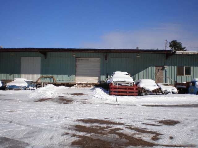
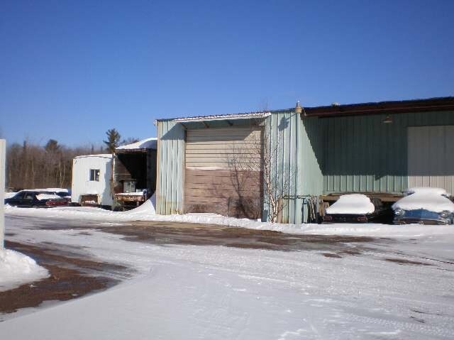
Property Record
357 Us Highway 41 E, Negaunee, MI 49866

Property Detail
357 Us Highway 41 E
52-10-123-119-00
SEC 23 T48N R26W 1.45 A. BEG AT S.E. COR TH W ALONG S. LINE OF SEC. 973.90'; TH N 726.35'; TH N 10DEG 49'02E 131.45' TO POB.
Commercialnec
Marquette
GB GENERAL
Michigan
B and X Area of moderate flood hazard, usually the area between the limits of the 100-year and 500-year floods.
1.45 AC
2025
Upper Peninsula
2025
Other Market Areas
001600
Marquette, MI
7,400 SF
NEARBY LISTINGS FOR SALE OR LEASE
-
-
View all Negaunee listings for sale on LoopNet.com
DEMOGRAPHICS near 357 Us Highway 41 E
1 mile
3 mile
5 mile
2025 Total Population
580
3,214
15,347
2030 Population
591
3,246
15,439
Pop Growth 2025-2030
+ 1.90%
+ 1.00%
+ 0.60%
Average Age
42
42
41
2025 Total Households
228
1,306
6,451
HH Growth 2025-2030
+ 2.19%
+ 1.38%
+ 0.45%
Median Household Inc
$102,696
$89,573
$66,496
Avg Household Size
2.50
2.50
2.20
2025 Avg HH Vehicles
2.00
2.00
2.00
Median Home Value
$316,000
$321,186
$268,620
Median Year Built
1980
1983
1977
Nearby Places
Map Layers
Map Styles
 Street
 Aerial
Layers
 Traffic
 Biking
Places
Listings with unknown addresses are not visible on the map
- Restaurants
- Banks
- Shops
- Fitness
- Groceries
PUBLIC TRANSPORTATION
AIRPORT
Marquette/Sawyer Regional
Drive
Walk
Distance
Marquette/Sawyer Regional
33 min
20.4 mi
Freight Ports
Port Milwaukee
Drive
Walk
Distance
Port Milwaukee
355 min
289.8 mi
Nearby Properties
Address
Land Use
TOTAL SIZE
Lot Size
Zoning
Address
Land Use
TOTAL SIZE
Lot Size
Zoning
195,283 SF
10.25 AC
DD
Address
Land Use
TOTAL SIZE
Lot Size
Zoning
0.29 AC
R-3-L/R
Address
Land Use
TOTAL SIZE
Lot Size
Zoning
206,601 SF
21.83 AC
GB
Address
Land Use
TOTAL SIZE
Lot Size
Zoning
156,460 SF
14.25 AC
GB
Address
Land Use
TOTAL SIZE
Lot Size
Zoning
220,560 SF
22.20 AC
GB
Address
Land Use
TOTAL SIZE
Lot Size
Zoning
152.60 AC
RP
Address
Land Use
TOTAL SIZE
Lot Size
Zoning
178,083 SF
210 AC
PUD
Address
Land Use
TOTAL SIZE
Lot Size
Zoning
125,381 SF
13.11 AC
GB
Address
Land Use
TOTAL SIZE
Lot Size
Zoning
36,600 SF
6.06 AC
GB
Address
Land Use
TOTAL SIZE
Lot Size
Zoning
80,156 SF
7.70 AC
DD
Address
Land Use
TOTAL SIZE
Lot Size
Zoning
22,385 SF
17.82 AC
GB
Address
Land Use
TOTAL SIZE
Lot Size
Zoning
Address
Land Use
TOTAL SIZE
Lot Size
Zoning
37.63 AC
DD
Address
Land Use
TOTAL SIZE
Lot Size
Zoning
47,014 SF
90 AC
R-2-SFR
Address
Land Use
TOTAL SIZE
Lot Size
Zoning
54,048 SF
3.47 AC
GB
Address
Land Use
TOTAL SIZE
Lot Size
Zoning
80,000 SF
4 AC
GB
Address
Land Use
TOTAL SIZE
Lot Size
Zoning
25,920 SF
9.84 AC
DD
Address
Land Use
TOTAL SIZE
Lot Size
Zoning
12,000 SF
7.39 AC
UR
Address
Land Use
TOTAL SIZE
Lot Size
Zoning
30,390 SF
2.68 AC
GB
Address
Land Use
TOTAL SIZE
Lot Size
Zoning
25,368 SF
5.99 AC
DD
Address
Land Use
TOTAL SIZE
Lot Size
Zoning
144,017 SF
104 AC
PUD
Address
Land Use
TOTAL SIZE
Lot Size
Zoning
30,067 SF
4.81 AC
GB
Address
Land Use
TOTAL SIZE
Lot Size
Zoning
48,530 SF
2 AC
GB
Address
Land Use
TOTAL SIZE
Lot Size
Zoning
46,017 SF
12.35 AC
GB GENERAL
Address
Land Use
TOTAL SIZE
Lot Size
Zoning
20,382 SF
2.68 AC
GB
Address
Land Use
TOTAL SIZE
Lot Size
Zoning
10 AC
UR
Address
Land Use
TOTAL SIZE
Lot Size
Zoning
47,014 SF
22.67 AC
R-2-SFR
Address
Land Use
TOTAL SIZE
Lot Size
Zoning
25,800 SF
7.09 AC
GB
Address
Land Use
TOTAL SIZE
Lot Size
Zoning
19,916 SF
1.96 AC
GB
Address
Land Use
TOTAL SIZE
Lot Size
Zoning
3,376 SF
3.98 AC
DD
The World's #1 Commercial Real Estate Marketplace
Connect with us
© 2026 CoStar Group
The information above has been obtained from sources believed reliable. While we do not doubt its accuracy we have not verified it and make no guarantee, warranty or representation about it. It is your responsibility to independently confirm its accuracy and completeness. Any projections, opinions, assumptions, or estimates used are for example only and do not represent the current or future performance of the property. The value of this transaction to you depends on tax and other factors which should be evaluated by your tax, financial, and legal advisors. You and your advisors should conduct a careful, independent investigation of the property to determine to your satisfaction the suitability of the property for your needs.