Property Record
3570 County Road 57, Robstown, TX 78380
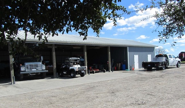

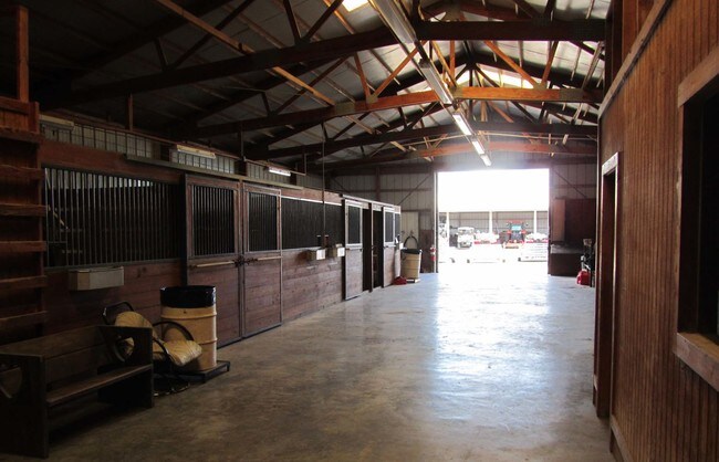
Property Detail
3570 County Road 57
Corpus Christi, TX
ASSESSORS MAP 148 20.25 ACS OUT OF SHR 2
186378
NUECES
Privatepreserveopenspacevacantlandforestlandconservation
Texas
AE The base floodplain where base flood elevations are provided. AE Zones are now used on new format FIRMs instead of A1-A30 Zones.
20.25 AC
2024
Northwest
2025
Corpus Christi
005406
NEARBY LISTINGS FOR SALE OR LEASE
DEMOGRAPHICS near 3570 County Road 57
1 mile
3 mile
5 mile
2025 Total Population
35
1,417
10,270
2030 Population
38
1,469
10,381
Pop Growth 2025-2030
+ 8.57%
+ 3.67%
+ 1.08%
Average Age
39
37
37
2025 Total Households
11
456
3,431
HH Growth 2025-2030
+ 9.09%
+ 3.51%
+ 0.85%
Median Household Inc
$67,500
$55,817
$78,413
Avg Household Size
2.90
3.10
2.90
2025 Avg HH Vehicles
2.00
2.00
2.00
Median Home Value
$450,000
$65,258
$189,290
Median Year Built
2010
1979
1990
Nearby Places
Map Layers
Map Styles
 Street
 Aerial
Layers
 Traffic
 Biking
Places
Listings with unknown addresses are not visible on the map
- Restaurants
- Banks
- Shops
- Fitness
- Groceries
PUBLIC TRANSPORTATION
AIRPORT
Corpus Christi International
Drive
Walk
Distance
Corpus Christi International
15 min
6.5 mi
Nearby Properties
Address
Land Use
TOTAL SIZE
Lot Size
Zoning
Address
Land Use
TOTAL SIZE
Lot Size
Zoning
148,070 SF
17 AC
Address
Land Use
TOTAL SIZE
Lot Size
Zoning
137,966 SF
29.40 AC
Address
Land Use
TOTAL SIZE
Lot Size
Zoning
57,512 SF
9.65 AC
Address
Land Use
TOTAL SIZE
Lot Size
Zoning
64,162 SF
15.67 AC
Address
Land Use
TOTAL SIZE
Lot Size
Zoning
101,530 SF
14.30 AC
Address
Land Use
TOTAL SIZE
Lot Size
Zoning
32,928 SF
21.29 AC
Address
Land Use
TOTAL SIZE
Lot Size
Zoning
18,880 SF
6.13 AC
Address
Land Use
TOTAL SIZE
Lot Size
Zoning
20,000 SF
2.41 AC
Address
Land Use
TOTAL SIZE
Lot Size
Zoning
18,073 SF
5.06 AC
Address
Land Use
TOTAL SIZE
Lot Size
Zoning
32,030 SF
5 AC
Address
Land Use
TOTAL SIZE
Lot Size
Zoning
8 AC
T-1B
Address
Land Use
TOTAL SIZE
Lot Size
Zoning
2,100 SF
10.69 AC
T-1B
Address
Land Use
TOTAL SIZE
Lot Size
Zoning
18,810 SF
2.79 AC
I-2
Address
Land Use
TOTAL SIZE
Lot Size
Zoning
8,800 SF
0.80 AC
R1B
Address
Land Use
TOTAL SIZE
Lot Size
Zoning
11,992 SF
2.50 AC
Address
Land Use
TOTAL SIZE
Lot Size
Zoning
14,290 SF
5 AC
Address
Land Use
TOTAL SIZE
Lot Size
Zoning
11,800 SF
6.26 AC
Address
Land Use
TOTAL SIZE
Lot Size
Zoning
28,164 SF
1.36 AC
I-3
Address
Land Use
TOTAL SIZE
Lot Size
Zoning
11,743 SF
2.56 AC
Address
Land Use
TOTAL SIZE
Lot Size
Zoning
24.64 AC
R1B
Address
Land Use
TOTAL SIZE
Lot Size
Zoning
9,668 SF
4 AC
OCL
Address
Land Use
TOTAL SIZE
Lot Size
Zoning
5,320 SF
5.74 AC
Address
Land Use
TOTAL SIZE
Lot Size
Zoning
112.07 AC
Address
Land Use
TOTAL SIZE
Lot Size
Zoning
15,936 SF
2.23 AC
I-3
Address
Land Use
TOTAL SIZE
Lot Size
Zoning
6,306 SF
2 AC
Address
Land Use
TOTAL SIZE
Lot Size
Zoning
4,272 SF
4 AC
Address
Land Use
TOTAL SIZE
Lot Size
Zoning
135.29 AC
I3
Address
Land Use
TOTAL SIZE
Lot Size
Zoning
116.87 AC
I3
Address
Land Use
TOTAL SIZE
Lot Size
Zoning
62.97 AC
OCL
Address
Land Use
TOTAL SIZE
Lot Size
Zoning
21,065 SF
1.36 AC
I-3
The World's #1 Commercial Real Estate Marketplace
Connect with us
© 2026 CoStar Group
The information above has been obtained from sources believed reliable. While we do not doubt its accuracy we have not verified it and make no guarantee, warranty or representation about it. It is your responsibility to independently confirm its accuracy and completeness. Any projections, opinions, assumptions, or estimates used are for example only and do not represent the current or future performance of the property. The value of this transaction to you depends on tax and other factors which should be evaluated by your tax, financial, and legal advisors. You and your advisors should conduct a careful, independent investigation of the property to determine to your satisfaction the suitability of the property for your needs.