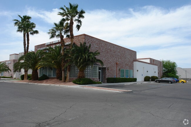
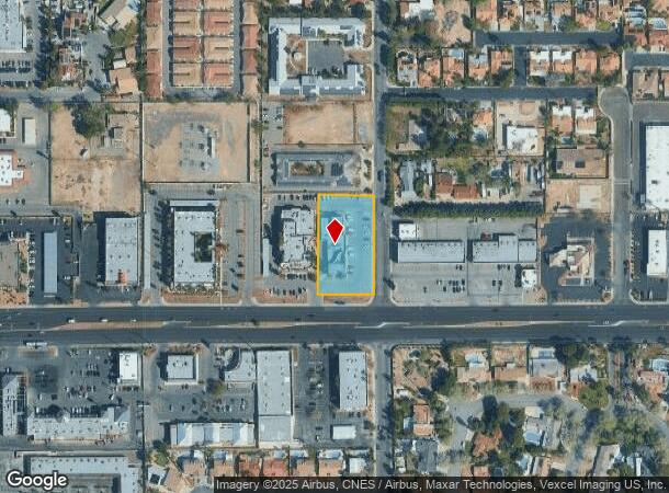
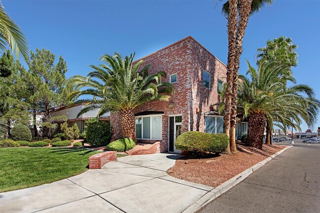
Property Record
3570 E Flamingo Rd, Las Vegas, NV 89121

NEARBY LISTINGS FOR SALE OR LEASE
Property Detail
3570 E Flamingo Rd
161-18-401-060
PT SW4 SW4 SEC 18 21 62
Commercialnec
Clark
X
Nevada
32003C2580F
1.09 AC
2025
Central East Las Vegas
2025
Las Vegas
001706
Las Vegas-Henderson-Paradise, NV
9,457 SF
DEMOGRAPHICS near 3570 E Flamingo Rd
1 Mile
3 Mile
5 Mile
2024 Total Population
17,436
205,321
468,349
2029 Population
18,621
219,565
501,852
Pop Growth 2024-2029
+ 6.80%
+ 6.94%
+ 7.15%
Average Age
44
39
39
2024 Total Households
7,124
81,452
181,915
HH Growth 2024-2029
+ 6.78%
+ 6.94%
+ 7.25%
Median Household Inc
$60,618
$42,468
$44,988
Avg Household Size
2.40
2.40
2.50
2024 Avg HH Vehicles
2.00
1.00
2.00
Median Home Value
$313,868
$265,846
$285,598
Median Year Built
1976
1980
1986
Nearby Places
Map Layers
Map Styles
 Street
 Aerial
- Restaurants
- Banks
- Shops
- Fitness
- Groceries
PUBLIC TRANSPORTATION
AIRPORT
Harry Reid International
DRIVE
WALK
Distance
Harry Reid International
42 min
11.4 mi
Boulder City Municipal
DRIVE
WALK
Distance
Boulder City Municipal
30 min
21.0 mi
SALE & LEASE HISTORY
LISTING DATE
SALE/LEASE

Sep 28, 2016
For Lease
Sep 28, 2016
For Sale
Sep 03, 2020
For Lease
Oct 27, 2020
For Sale
Jun 17, 2020
For Lease
Nearby Properties
Address
Land Use
TOTAL SIZE
Lot Size
Zoning
Address
Land Use
TOTAL SIZE
Lot Size
Zoning
265,609 SF
47.36 AC
H1
Address
Land Use
TOTAL SIZE
Lot Size
Zoning
138.07 AC
PF
Address
Land Use
TOTAL SIZE
Lot Size
Zoning
281,120 SF
21.38 AC
Address
Land Use
TOTAL SIZE
Lot Size
Zoning
345,133 SF
27.01 AC
H1
Address
Land Use
TOTAL SIZE
Lot Size
Zoning
44.69 AC
PF
Address
Land Use
TOTAL SIZE
Lot Size
Zoning
72.03 AC
PF
Address
Land Use
TOTAL SIZE
Lot Size
Zoning
709,943 SF
43.10 AC
C2
Address
Land Use
TOTAL SIZE
Lot Size
Zoning
6,396 SF
15.06 AC
Address
Land Use
TOTAL SIZE
Lot Size
Zoning
95,928 SF
3.71 AC
C:U-V
Address
Land Use
TOTAL SIZE
Lot Size
Zoning
239,785 SF
2.20 AC
C:R-5
Address
Land Use
TOTAL SIZE
Lot Size
Zoning
513,085 SF
53.27 AC
C2
Address
Land Use
TOTAL SIZE
Lot Size
Zoning
198.15 AC
PF
Address
Land Use
TOTAL SIZE
Lot Size
Zoning
38,764 SF
12.66 AC
H1
Address
Land Use
TOTAL SIZE
Lot Size
Zoning
4,460 SF
27.52 AC
Address
Land Use
TOTAL SIZE
Lot Size
Zoning
15.95 AC
PF
Address
Land Use
TOTAL SIZE
Lot Size
Zoning
11.18 AC
PF
Address
Land Use
TOTAL SIZE
Lot Size
Zoning
56,526 SF
12.44 AC
C2
Address
Land Use
TOTAL SIZE
Lot Size
Zoning
5,649 SF
15.32 AC
R4
Address
Land Use
TOTAL SIZE
Lot Size
Zoning
6,659 SF
6.05 AC
H1
Address
Land Use
TOTAL SIZE
Lot Size
Zoning
7,908 SF
24.13 AC
R4
Address
Land Use
TOTAL SIZE
Lot Size
Zoning
4.18 AC
PF
Address
Land Use
TOTAL SIZE
Lot Size
Zoning
554,741 SF
9.79 AC
C:MLZ
Address
Land Use
TOTAL SIZE
Lot Size
Zoning
150,772 SF
2.46 AC
Address
Land Use
TOTAL SIZE
Lot Size
Zoning
13,589 SF
56.80 AC
PF
Address
Land Use
TOTAL SIZE
Lot Size
Zoning
7,304 SF
12.58 AC
R4
Address
Land Use
TOTAL SIZE
Lot Size
Zoning
6,834 SF
5.14 AC
C2
Address
Land Use
TOTAL SIZE
Lot Size
Zoning
36.86 AC
PF
Address
Land Use
TOTAL SIZE
Lot Size
Zoning
6,117 SF
14.90 AC
PF
Address
Land Use
TOTAL SIZE
Lot Size
Zoning
40.07 AC
PF
Address
Land Use
TOTAL SIZE
Lot Size
Zoning
4,564 SF
15.71 AC
R4
The World's #1 Commercial Real Estate Marketplace
Connect with us
© 2025 CoStar Group
The information above has been obtained from sources believed reliable. While we do not doubt its accuracy we have not verified it and make no guarantee, warranty or representation about it. It is your responsibility to independently confirm its accuracy and completeness. Any projections, opinions, assumptions, or estimates used are for example only and do not represent the current or future performance of the property. The value of this transaction to you depends on tax and other factors which should be evaluated by your tax, financial, and legal advisors. You and your advisors should conduct a careful, independent investigation of the property to determine to your satisfaction the suitability of the property for your needs.