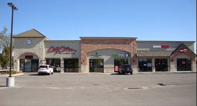
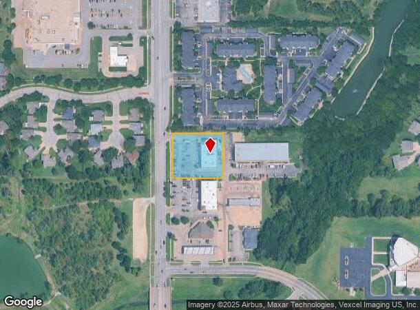
Property Record
3570 N Woodlawn Blvd, Wichita, KS 67220
Current Lease Availabilities
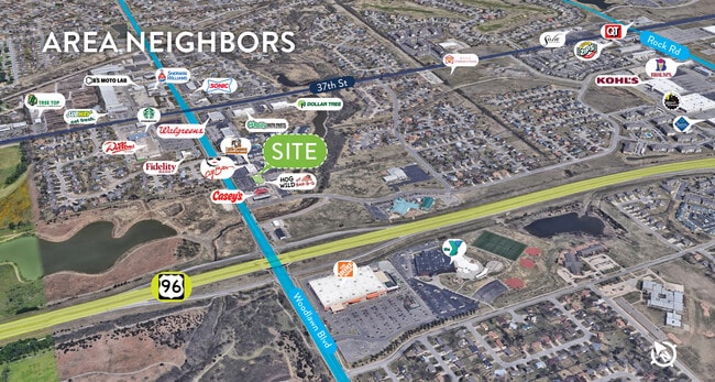
NEARBY LISTINGS FOR SALE OR LEASE
Property Detail
3570 N Woodlawn Blvd
Wichita, KS
Linder Add
109-31-0-22-03-001.01
THAT PT LOT 1 BEG SW COR N 200 FT E 228.26 FT S 200 FT W 229 FT TO BEG LINDER ADDITION
Storebuilding
Sedgwick
X
Kansas
20173C0357G
1
2024
1.05 AC
2025
Northeast
010802
Wichita
8,750 SF
DEMOGRAPHICS near 3570 N Woodlawn Blvd
1 Mile
3 Mile
5 Mile
2024 Total Population
8,746
47,852
117,290
2029 Population
8,819
48,538
119,680
Pop Growth 2024-2029
+ 0.83%
+ 1.43%
+ 2.04%
Average Age
37
39
38
2024 Total Households
3,787
19,465
46,102
HH Growth 2024-2029
+ 0.79%
+ 1.34%
+ 1.94%
Median Household Inc
$64,510
$64,679
$63,334
Avg Household Size
2.30
2.30
2.40
2024 Avg HH Vehicles
2.00
2.00
2.00
Median Home Value
$172,185
$196,799
$187,701
Median Year Built
1991
1987
1975
Nearby Places
- Restaurants
- Banks
- Shops
- Fitness
- Groceries
PUBLIC TRANSPORTATION
AIRPORT
Wichita Dwight D Eisenhower Ntl
DRIVE
WALK
Distance
Wichita Dwight D Eisenhower Ntl
24 min
16.1 mi
Nearby Properties
Address
Land Use
TOTAL SIZE
Lot Size
Zoning
Address
Land Use
TOTAL SIZE
Lot Size
Zoning
481,160 SF
63.37 AC
SF-5
Address
Land Use
TOTAL SIZE
Lot Size
Zoning
346,728 SF
15.91 AC
SF-5
Address
Land Use
TOTAL SIZE
Lot Size
Zoning
179,764 SF
42.17 AC
SF-5,LI
Address
Land Use
TOTAL SIZE
Lot Size
Zoning
304,863 SF
74.13 AC
SF5
Address
Land Use
TOTAL SIZE
Lot Size
Zoning
340,322 SF
32.82 AC
SF-5,B
Address
Land Use
TOTAL SIZE
Lot Size
Zoning
256,570 SF
53.92 AC
R3
Address
Land Use
TOTAL SIZE
Lot Size
Zoning
243,768 SF
5.42 AC
LI
Address
Land Use
TOTAL SIZE
Lot Size
Zoning
366,272 SF
332.54 AC
LI
Address
Land Use
TOTAL SIZE
Lot Size
Zoning
148,617 SF
17.27 AC
SF-5
Address
Land Use
TOTAL SIZE
Lot Size
Zoning
104,331 SF
SF-5
Address
Land Use
TOTAL SIZE
Lot Size
Zoning
305,447 SF
46.77 AC
GI
Address
Land Use
TOTAL SIZE
Lot Size
Zoning
103,261 SF
5.49 AC
B
Address
Land Use
TOTAL SIZE
Lot Size
Zoning
129,965 SF
41.88 AC
R3
Address
Land Use
TOTAL SIZE
Lot Size
Zoning
186,902 SF
5.24 AC
SF-5
Address
Land Use
TOTAL SIZE
Lot Size
Zoning
169,134 SF
18.97 AC
SF-5
Address
Land Use
TOTAL SIZE
Lot Size
Zoning
79,739 SF
10.11 AC
R6
Address
Land Use
TOTAL SIZE
Lot Size
Zoning
199,468 SF
24.45 AC
SF-5
Address
Land Use
TOTAL SIZE
Lot Size
Zoning
147,784 SF
39.28 AC
SF-5
Address
Land Use
TOTAL SIZE
Lot Size
Zoning
73,314 SF
3.18 AC
SF-5
Address
Land Use
TOTAL SIZE
Lot Size
Zoning
69,125 SF
16.79 AC
MF-29,MF-1
Address
Land Use
TOTAL SIZE
Lot Size
Zoning
102,200 SF
8.77 AC
R6
Address
Land Use
TOTAL SIZE
Lot Size
Zoning
74,242 SF
23.99 AC
GC
Address
Land Use
TOTAL SIZE
Lot Size
Zoning
92,973 SF
5.52 AC
PUD
Address
Land Use
TOTAL SIZE
Lot Size
Zoning
67,067 SF
8.36 AC
SF-5
Address
Land Use
TOTAL SIZE
Lot Size
Zoning
111,805 SF
20.09 AC
SF-5
Address
Land Use
TOTAL SIZE
Lot Size
Zoning
84,452 SF
0.46 AC
B
Address
Land Use
TOTAL SIZE
Lot Size
Zoning
121,541 SF
47.63 AC
LI
Address
Land Use
TOTAL SIZE
Lot Size
Zoning
40,267 SF
10.55 AC
R6
Address
Land Use
TOTAL SIZE
Lot Size
Zoning
92,735 SF
7.28 AC
R4
Address
Land Use
TOTAL SIZE
Lot Size
Zoning
60,232 SF
0.72 AC
SF-5
The World's #1 Commercial Real Estate Marketplace
Connect with us
© 2025 CoStar Group
The information above has been obtained from sources believed reliable. While we do not doubt its accuracy we have not verified it and make no guarantee, warranty or representation about it. It is your responsibility to independently confirm its accuracy and completeness. Any projections, opinions, assumptions, or estimates used are for example only and do not represent the current or future performance of the property. The value of this transaction to you depends on tax and other factors which should be evaluated by your tax, financial, and legal advisors. You and your advisors should conduct a careful, independent investigation of the property to determine to your satisfaction the suitability of the property for your needs.