Property Record
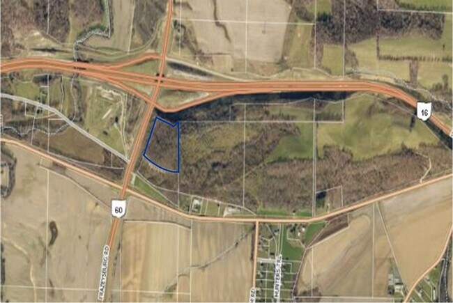
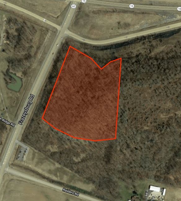
3570 Raiders Rd, Dresden, OH 43821

Property Detail
3570 Raiders Rd
Zanesville, OH
R 8 TP 3 QR TP 1 LOT 15 ADAMS 1ST 9.487A
10-08-51-05-001
MUSKINGUM
Timberlandforesttreesagricultural
Ohio
B and X Area of moderate flood hazard, usually the area between the limits of the 100-year and 500-year floods.
15
2025
9.49 AC
2025
Ohio South Area
911100
Other Market Areas
NEARBY LISTINGS FOR SALE OR LEASE
-
-
View all Dresden listings for sale on LoopNet.com
DEMOGRAPHICS near 3570 Raiders Rd
1 mile
3 mile
5 mile
2025 Total Population
137
2,873
4,917
2030 Population
135
2,851
4,904
Pop Growth 2025-2030
(1.46%)
(0.77%)
(0.26%)
Average Age
39
40
40
2025 Total Households
52
1,126
1,898
HH Growth 2025-2030
(1.92%)
(0.71%)
(0.21%)
Median Household Inc
$72,749
$67,655
$66,351
Avg Household Size
2.60
2.40
2.50
2025 Avg HH Vehicles
2.00
2.00
2.00
Median Home Value
$212,500
$166,786
$184,911
Median Year Built
1978
1972
1976
Nearby Places
Map Layers
Map Styles
 Street
 Aerial
Transit
 Traffic
 Biking
Places
Listings with unknown addresses are not visible on the map
- Restaurants
- Banks
- Shops
- Fitness
- Groceries
SALE & LEASE HISTORY
LISTING DATE
SALE/LEASE

May 07, 2020
For Sale
Nearby Properties
Address
Land Use
TOTAL SIZE
Lot Size
Zoning
Address
Land Use
TOTAL SIZE
Lot Size
Zoning
38,962 SF
9.39 AC
Address
Land Use
TOTAL SIZE
Lot Size
Zoning
82,272 SF
5.91 AC
Address
Land Use
TOTAL SIZE
Lot Size
Zoning
121,905 SF
6.12 AC
Address
Land Use
TOTAL SIZE
Lot Size
Zoning
13,841 SF
5 AC
Address
Land Use
TOTAL SIZE
Lot Size
Zoning
385.70 AC
Address
Land Use
TOTAL SIZE
Lot Size
Zoning
7,452 SF
2.73 AC
Address
Land Use
TOTAL SIZE
Lot Size
Zoning
2.01 AC
Address
Land Use
TOTAL SIZE
Lot Size
Zoning
342.76 AC
Address
Land Use
TOTAL SIZE
Lot Size
Zoning
4.98 AC
Address
Land Use
TOTAL SIZE
Lot Size
Zoning
17,143 SF
0.31 AC
Address
Land Use
TOTAL SIZE
Lot Size
Zoning
14,200 SF
1.95 AC
Address
Land Use
TOTAL SIZE
Lot Size
Zoning
10,143 SF
8.57 AC
Address
Land Use
TOTAL SIZE
Lot Size
Zoning
27,512 SF
7.20 AC
Address
Land Use
TOTAL SIZE
Lot Size
Zoning
8,064 SF
7.92 AC
Address
Land Use
TOTAL SIZE
Lot Size
Zoning
261.33 AC
Address
Land Use
TOTAL SIZE
Lot Size
Zoning
206.39 AC
Address
Land Use
TOTAL SIZE
Lot Size
Zoning
156.08 AC
Address
Land Use
TOTAL SIZE
Lot Size
Zoning
172.02 AC
Address
Land Use
TOTAL SIZE
Lot Size
Zoning
1,472 SF
3 AC
Address
Land Use
TOTAL SIZE
Lot Size
Zoning
7,260 SF
3.81 AC
Address
Land Use
TOTAL SIZE
Lot Size
Zoning
6,000 SF
2.71 AC
Address
Land Use
TOTAL SIZE
Lot Size
Zoning
7,116 SF
0.17 AC
Address
Land Use
TOTAL SIZE
Lot Size
Zoning
15,522 SF
0.37 AC
Address
Land Use
TOTAL SIZE
Lot Size
Zoning
3,119 SF
0.72 AC
Address
Land Use
TOTAL SIZE
Lot Size
Zoning
178.76 AC
Address
Land Use
TOTAL SIZE
Lot Size
Zoning
160 AC
Address
Land Use
TOTAL SIZE
Lot Size
Zoning
138.92 AC
Address
Land Use
TOTAL SIZE
Lot Size
Zoning
8,879 SF
0.88 AC
Address
Land Use
TOTAL SIZE
Lot Size
Zoning
26.83 AC
Address
Land Use
TOTAL SIZE
Lot Size
Zoning
160.81 AC
The World's #1 Commercial Real Estate Marketplace
Connect with us
© 2026 CoStar Group
The information above has been obtained from sources believed reliable. While we do not doubt its accuracy we have not verified it and make no guarantee, warranty or representation about it. It is your responsibility to independently confirm its accuracy and completeness. Any projections, opinions, assumptions, or estimates used are for example only and do not represent the current or future performance of the property. The value of this transaction to you depends on tax and other factors which should be evaluated by your tax, financial, and legal advisors. You and your advisors should conduct a careful, independent investigation of the property to determine to your satisfaction the suitability of the property for your needs.