Property Record
3571 State Route 4, Hudson Falls, NY 12839
NEARBY LISTINGS FOR SALE OR LEASE
-
-
View all Hudson Falls listings for sale on LoopNet.com
Property Detail
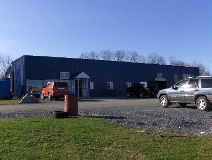
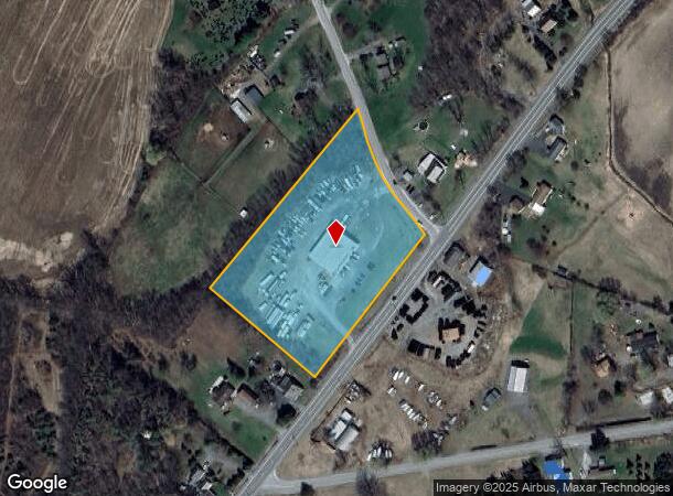
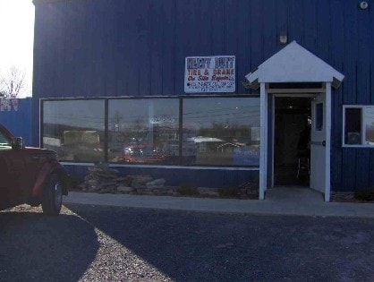
3571 State Route 4
Glens Falls, NY
Washington
534489-138-000-0001-072-000-0000
New York
Autorepair
72.000
2025
4 AC
2024
Washington County
080302
Albany/Schenectady/Troy
7,500 SF
DEMOGRAPHICS near 3571 State Route 4
1 Mile
3 Mile
5 Mile
2024 Total Population
439
5,233
21,996
2029 Population
436
5,180
21,751
Pop Growth 2024-2029
(0.68%)
(1.01%)
(1.11%)
Average Age
44
42
42
2024 Total Households
174
2,212
9,389
HH Growth 2024-2029
(0.57%)
(1.08%)
(1.18%)
Median Household Inc
$85,000
$74,386
$64,511
Avg Household Size
2.50
2.30
2.20
2024 Avg HH Vehicles
2.00
2.00
2.00
Median Home Value
$196,363
$172,582
$177,143
Median Year Built
1982
1980
1965
Nearby Places
Map Layers
Map Styles
 Street
 Aerial
- Restaurants
- Banks
- Shops
- Fitness
- Groceries
PUBLIC TRANSPORTATION
COMMUTER RAIL
Fort Edward Amtrak (Adirondack - Amtrak, Ethan Allen Express - Amtrak)
DRIVE
WALK
Distance
Fort Edward Amtrak (Adirondack - Amtrak, Ethan Allen Express - Amtrak)
14 min
6.4 mi
Freight Ports
Albany, NY Port
DRIVE
WALK
Distance
Albany, NY Port
83 min
60.4 mi
Nearby Properties
Address
Land Use
TOTAL SIZE
Lot Size
Zoning
Address
Land Use
TOTAL SIZE
Lot Size
Zoning
7,823 SF
27.33 AC
LDR25
Address
Land Use
TOTAL SIZE
Lot Size
Zoning
119,455 SF
66.60 AC
LDR25
Address
Land Use
TOTAL SIZE
Lot Size
Zoning
141,480 SF
29.05 AC
RA
Address
Land Use
TOTAL SIZE
Lot Size
Zoning
19,317 SF
12.97 AC
CLI
Address
Land Use
TOTAL SIZE
Lot Size
Zoning
33,270 SF
68.64 AC
RA1A
Address
Land Use
TOTAL SIZE
Lot Size
Zoning
36,249 SF
5.40 AC
COM1A
Address
Land Use
TOTAL SIZE
Lot Size
Zoning
4,200 SF
10.74 AC
LDR25
Address
Land Use
TOTAL SIZE
Lot Size
Zoning
136,449 SF
14.92 AC
LDR25
Address
Land Use
TOTAL SIZE
Lot Size
Zoning
68,565 SF
25.85 AC
LDR25
Address
Land Use
TOTAL SIZE
Lot Size
Zoning
75,960 SF
5.41 AC
PIC75
Address
Land Use
TOTAL SIZE
Lot Size
Zoning
26.50 AC
RA1A
Address
Land Use
TOTAL SIZE
Lot Size
Zoning
15,500 SF
8.33 AC
RA1A
Address
Land Use
TOTAL SIZE
Lot Size
Zoning
13,499 SF
3.66 AC
PIC75
Address
Land Use
TOTAL SIZE
Lot Size
Zoning
43,200 SF
3.30 AC
COM1A
Address
Land Use
TOTAL SIZE
Lot Size
Zoning
13,446 SF
2.07 AC
COM1A
Address
Land Use
TOTAL SIZE
Lot Size
Zoning
Address
Land Use
TOTAL SIZE
Lot Size
Zoning
25,000 SF
2.82 AC
CLI
Address
Land Use
TOTAL SIZE
Lot Size
Zoning
18,092 SF
15 AC
LDR25
Address
Land Use
TOTAL SIZE
Lot Size
Zoning
10,265 SF
4.59 AC
CLI
Address
Land Use
TOTAL SIZE
Lot Size
Zoning
2,592 SF
175.87 AC
RA1A
Address
Land Use
TOTAL SIZE
Lot Size
Zoning
10,800 SF
3.03 AC
COM1A
Address
Land Use
TOTAL SIZE
Lot Size
Zoning
33,750 SF
2.07 AC
PIC75
Address
Land Use
TOTAL SIZE
Lot Size
Zoning
20,840 SF
6.09 AC
CLI
Address
Land Use
TOTAL SIZE
Lot Size
Zoning
12,300 SF
125.60 AC
RA1A
Address
Land Use
TOTAL SIZE
Lot Size
Zoning
4,452 SF
88.40 AC
RA1A
Address
Land Use
TOTAL SIZE
Lot Size
Zoning
720 SF
25.10 AC
RA1A
Address
Land Use
TOTAL SIZE
Lot Size
Zoning
17,262 SF
1.50 AC
COM1A
Address
Land Use
TOTAL SIZE
Lot Size
Zoning
25,000 SF
2 AC
CLI
Address
Land Use
TOTAL SIZE
Lot Size
Zoning
30,300 SF
2.08 AC
PIC75
Address
Land Use
TOTAL SIZE
Lot Size
Zoning
3,904 SF
69.90 AC
RA1A
The World's #1 Commercial Real Estate Marketplace
Connect with us
© 2026 CoStar Group
The information above has been obtained from sources believed reliable. While we do not doubt its accuracy we have not verified it and make no guarantee, warranty or representation about it. It is your responsibility to independently confirm its accuracy and completeness. Any projections, opinions, assumptions, or estimates used are for example only and do not represent the current or future performance of the property. The value of this transaction to you depends on tax and other factors which should be evaluated by your tax, financial, and legal advisors. You and your advisors should conduct a careful, independent investigation of the property to determine to your satisfaction the suitability of the property for your needs.