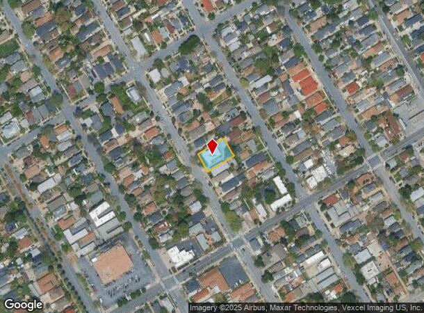
Property Record
358 N 7Th St, San Jose, CA 95112
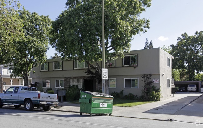
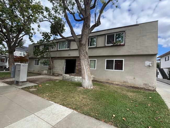

This Property Is For Sale
NEARBY LISTINGS FOR SALE OR LEASE
-
-
-
-
-
-
-
-
-
-
-
-
-
-
-
-
No Photo
-
View all San Jose listings for sale on LoopNet.com
Property Detail
358 N 7Th St
San Jose-Sunnyvale-Santa Clara, CA
D Devines Surv 01
249-50-022
MAP A PG 44 BLK 1 PART OF LOT 6,5
Multifamilydwelling
Santa Clara
D
California
06085C0232H
6,5
2024
0.28 AC
2025
Northside
501000
South Bay/San Jose
6,536 SF
DEMOGRAPHICS near 358 N 7Th St
1 mile
3 mile
5 mile
2024 Total Population
41,311
246,961
625,850
2029 Population
40,388
238,143
601,766
Pop Growth 2024-2029
(2.23%)
(3.57%)
(3.85%)
Average Age
37
38
39
2024 Total Households
16,250
82,962
205,363
HH Growth 2024-2029
(1.98%)
(3.60%)
(3.92%)
Median Household Inc
$105,800
$102,515
$118,236
Avg Household Size
2.30
2.70
2.90
2024 Avg HH Vehicles
2.00
2.00
2.00
Median Home Value
$995,125
$982,124
$1,019,962
Median Year Built
1978
1976
1974
Nearby Places
Map Layers
Map Styles
 Street
 Aerial
Transit
 Traffic
 Biking
Places
Listings with unknown addresses are not visible on the map
- Restaurants
- Banks
- Shops
- Fitness
- Groceries
PUBLIC TRANSPORTATION
COMMUTER RAIL
Drive
Walk
Distance
5 min
1.7 mi
Drive
Walk
Distance
5 min
1.9 mi
AIRPORT
Norman Y Mineta San Jose International
Drive
Walk
Distance
Norman Y Mineta San Jose International
8 min
3.5 mi
Metro Oakland International
Drive
Walk
Distance
Metro Oakland International
47 min
35.2 mi
San Francisco International
Drive
Walk
Distance
San Francisco International
47 min
36.4 mi
Freight Ports
Port of Redwood City
Drive
Walk
Distance
Port of Redwood City
32 min
23.3 mi
Nearby Properties
Address
Land Use
TOTAL SIZE
Lot Size
Zoning
Address
Land Use
TOTAL SIZE
Lot Size
Zoning
2.50 AC
DC
Address
Land Use
TOTAL SIZE
Lot Size
Zoning
576,892 SF
8.28 AC
APD
Address
Land Use
TOTAL SIZE
Lot Size
Zoning
194,790 SF
5.30 AC
APDCI
Address
Land Use
TOTAL SIZE
Lot Size
Zoning
1.73 AC
DC
Address
Land Use
TOTAL SIZE
Lot Size
Zoning
837,391 SF
1.42 AC
DC
Address
Land Use
TOTAL SIZE
Lot Size
Zoning
242,320 SF
8.01 AC
TEC
Address
Land Use
TOTAL SIZE
Lot Size
Zoning
33.32 AC
R140
Address
Land Use
TOTAL SIZE
Lot Size
Zoning
281,574 SF
32.09 AC
IP
Address
Land Use
TOTAL SIZE
Lot Size
Zoning
320,000 SF
15.18 AC
APD
Address
Land Use
TOTAL SIZE
Lot Size
Zoning
0.95 AC
CG
Address
Land Use
TOTAL SIZE
Lot Size
Zoning
486,104 SF
5.43 AC
ML
Address
Land Use
TOTAL SIZE
Lot Size
Zoning
194,530 SF
12.26 AC
APD
Address
Land Use
TOTAL SIZE
Lot Size
Zoning
590,000 SF
2.33 AC
C3
Address
Land Use
TOTAL SIZE
Lot Size
Zoning
557,448 SF
1.46 AC
DC
Address
Land Use
TOTAL SIZE
Lot Size
Zoning
333,472 SF
1.24 AC
APD
Address
Land Use
TOTAL SIZE
Lot Size
Zoning
289,503 SF
0.97 AC
DC
Address
Land Use
TOTAL SIZE
Lot Size
Zoning
330,927 SF
2.35 AC
M1
Address
Land Use
TOTAL SIZE
Lot Size
Zoning
445,687 SF
6.44 AC
A(PD)
Address
Land Use
TOTAL SIZE
Lot Size
Zoning
340,000 SF
0.65 AC
CG(PD
Address
Land Use
TOTAL SIZE
Lot Size
Zoning
194,549 SF
2.76 AC
APDCI
Address
Land Use
TOTAL SIZE
Lot Size
Zoning
505,150 SF
35.68 AC
CIC
Address
Land Use
TOTAL SIZE
Lot Size
Zoning
381,000 SF
1.40 AC
DC
Address
Land Use
TOTAL SIZE
Lot Size
Zoning
11.96 AC
M4
Address
Land Use
TOTAL SIZE
Lot Size
Zoning
429,535 SF
7.44 AC
C
Address
Land Use
TOTAL SIZE
Lot Size
Zoning
491,622 SF
4.18 AC
A(PD)
Address
Land Use
TOTAL SIZE
Lot Size
Zoning
286,350 SF
0.80 AC
C
Address
Land Use
TOTAL SIZE
Lot Size
Zoning
299,278 SF
3.67 AC
M1
Address
Land Use
TOTAL SIZE
Lot Size
Zoning
3.74 AC
APD
Address
Land Use
TOTAL SIZE
Lot Size
Zoning
279,230 SF
1.69 AC
C3H
Address
Land Use
TOTAL SIZE
Lot Size
Zoning
226,000 SF
0.82 AC
DC
The World's #1 Commercial Real Estate Marketplace
Connect with us
© 2026 CoStar Group
The information above has been obtained from sources believed reliable. While we do not doubt its accuracy we have not verified it and make no guarantee, warranty or representation about it. It is your responsibility to independently confirm its accuracy and completeness. Any projections, opinions, assumptions, or estimates used are for example only and do not represent the current or future performance of the property. The value of this transaction to you depends on tax and other factors which should be evaluated by your tax, financial, and legal advisors. You and your advisors should conduct a careful, independent investigation of the property to determine to your satisfaction the suitability of the property for your needs.