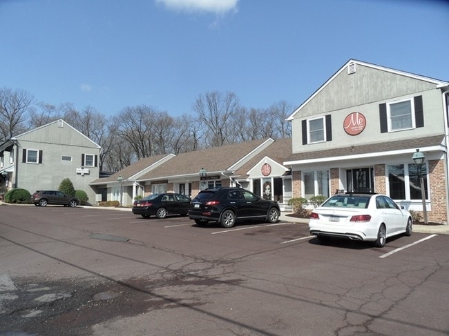
Property Record
354 W Bridge St, Morrisville, PA 19067

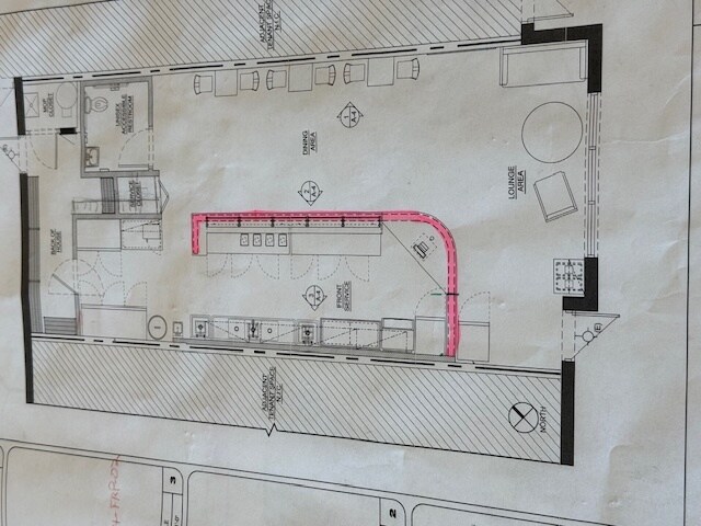
Current Lease Availabilities
NEARBY LISTINGS FOR SALE OR LEASE
Property Detail
354 W Bridge St
27-001-001-002-354
York Plac E Condo
Officebuilding
UNIT 354 BLDG B YORK PLAC E CONDO
X
Bucks
42017C0327J
Pennsylvania
2024
0.02 AC
2025
Lower Bucks County
105704
Philadelphia
1,225 SF
Philadelphia-Camden-Wilmington, PA-NJ-DE-MD
DEMOGRAPHICS near 354 W Bridge St
1 Mile
3 Mile
5 Mile
2024 Total Population
4,578
13,752
22,224
2029 Population
4,564
13,759
22,082
Pop Growth 2024-2029
(0.31%)
+ 0.05%
(0.64%)
Average Age
49
48
48
2024 Total Households
2,106
6,276
9,494
HH Growth 2024-2029
(0.24%)
+ 0.18%
(0.51%)
Median Household Inc
$147,058
$129,294
$140,995
Avg Household Size
2.20
2.20
2.30
2024 Avg HH Vehicles
2.00
2.00
2.00
Median Home Value
$706,666
$638,976
$693,218
Median Year Built
1979
1973
1975
Nearby Places
- Restaurants
- Banks
- Shops
- Fitness
- Groceries
PUBLIC TRANSPORTATION
AIRPORT
Lehigh Valley International
DRIVE
WALK
Distance
Lehigh Valley International
72 min
43.2 mi
Nearby Properties
Address
Land Use
TOTAL SIZE
Lot Size
Zoning
Address
Land Use
TOTAL SIZE
Lot Size
Zoning
11.51 AC
PRD
Address
Land Use
TOTAL SIZE
Lot Size
Zoning
4 AC
PRD
Address
Land Use
TOTAL SIZE
Lot Size
Zoning
Address
Land Use
TOTAL SIZE
Lot Size
Zoning
24,768 SF
1.47 AC
FP
Address
Land Use
TOTAL SIZE
Lot Size
Zoning
8,456 SF
2.36 AC
R-2
Address
Land Use
TOTAL SIZE
Lot Size
Zoning
7,765 SF
0.13 AC
CBD
Address
Land Use
TOTAL SIZE
Lot Size
Zoning
0.36 AC
CBD
Address
Land Use
TOTAL SIZE
Lot Size
Zoning
1,620 SF
0.23 AC
Address
Land Use
TOTAL SIZE
Lot Size
Zoning
4,924 SF
0.57 AC
CBD
Address
Land Use
TOTAL SIZE
Lot Size
Zoning
10,746 SF
1.68 AC
FP
Address
Land Use
TOTAL SIZE
Lot Size
Zoning
14,429 SF
2.20 AC
COM
Address
Land Use
TOTAL SIZE
Lot Size
Zoning
4,434 SF
1.47 AC
HC
Address
Land Use
TOTAL SIZE
Lot Size
Zoning
39,390 SF
1.80 AC
R-2
Address
Land Use
TOTAL SIZE
Lot Size
Zoning
100 AC
I-2
Address
Land Use
TOTAL SIZE
Lot Size
Zoning
4,423 SF
0.40 AC
R-2
Address
Land Use
TOTAL SIZE
Lot Size
Zoning
3,474 SF
4.09 AC
HC
Address
Land Use
TOTAL SIZE
Lot Size
Zoning
14,331 SF
3.88 AC
HC
Address
Land Use
TOTAL SIZE
Lot Size
Zoning
24,742 SF
0.11 AC
CBD
Address
Land Use
TOTAL SIZE
Lot Size
Zoning
5,600 SF
10.99 AC
HC
Address
Land Use
TOTAL SIZE
Lot Size
Zoning
9,100 SF
5.40 AC
HC
Address
Land Use
TOTAL SIZE
Lot Size
Zoning
11,452 SF
3.95 AC
PRD
Address
Land Use
TOTAL SIZE
Lot Size
Zoning
20,505 SF
0.14 AC
CBD
Address
Land Use
TOTAL SIZE
Lot Size
Zoning
0.42 AC
CBD
Address
Land Use
TOTAL SIZE
Lot Size
Zoning
9,975 SF
0.11 AC
CBD
Address
Land Use
TOTAL SIZE
Lot Size
Zoning
20,316 SF
8.81 AC
HC
Address
Land Use
TOTAL SIZE
Lot Size
Zoning
6,851 SF
8.55 AC
RL
Address
Land Use
TOTAL SIZE
Lot Size
Zoning
10,032 SF
0.10 AC
CBD
Address
Land Use
TOTAL SIZE
Lot Size
Zoning
3,403 SF
1.95 AC
COM
Address
Land Use
TOTAL SIZE
Lot Size
Zoning
10,371 SF
0.28 AC
R-2
Address
Land Use
TOTAL SIZE
Lot Size
Zoning
8,959 SF
5 AC
RR-6
The World's #1 Commercial Real Estate Marketplace
Connect with us
© 2025 CoStar Group
The information above has been obtained from sources believed reliable. While we do not doubt its accuracy we have not verified it and make no guarantee, warranty or representation about it. It is your responsibility to independently confirm its accuracy and completeness. Any projections, opinions, assumptions, or estimates used are for example only and do not represent the current or future performance of the property. The value of this transaction to you depends on tax and other factors which should be evaluated by your tax, financial, and legal advisors. You and your advisors should conduct a careful, independent investigation of the property to determine to your satisfaction the suitability of the property for your needs.