Property Record
3580 W 4Th St, Williamsport, PA 17701


NEARBY LISTINGS FOR SALE OR LEASE
-
-
View all Williamsport listings for sale on LoopNet.com
Property Detail
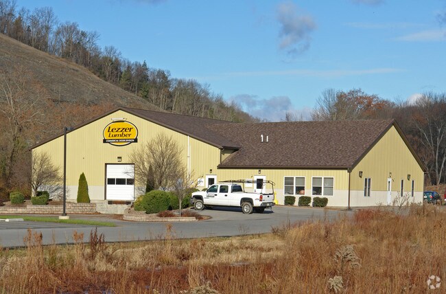
3580 W 4Th St
67-027.0-0208.02-000
Seventh Ward
Warehouse
Lycoming
AE
Pennsylvania
42081C0427G
1.02 AC
2025
Pennsylvania Central Area
2025
Other Market Areas
001000
Williamsport, PA
5,440 SF
DEMOGRAPHICS near 3580 W 4Th St
1 Mile
3 Mile
5 Mile
2024 Total Population
563
16,695
44,023
2029 Population
557
16,674
44,085
Pop Growth 2024-2029
(1.07%)
(0.13%)
+ 0.14%
Average Age
44
41
40
2024 Total Households
263
6,879
18,139
HH Growth 2024-2029
(1.14%)
(0.23%)
+ 0.13%
Median Household Inc
$73,429
$54,304
$50,237
Avg Household Size
2.10
2.30
2.20
2024 Avg HH Vehicles
2.00
2.00
2.00
Median Home Value
$193,845
$135,979
$149,359
Median Year Built
1978
1956
1954
Nearby Places
Map Layers
Map Styles
 Street
 Aerial
- Restaurants
- Banks
- Shops
- Fitness
- Groceries
Nearby Properties
Address
Land Use
TOTAL SIZE
Lot Size
Zoning
Address
Land Use
TOTAL SIZE
Lot Size
Zoning
494,653 SF
61.63 AC
RESR
Address
Land Use
TOTAL SIZE
Lot Size
Zoning
11,760 SF
4.67 AC
RESR
Address
Land Use
TOTAL SIZE
Lot Size
Zoning
76,264 SF
9.55 AC
INDR
Address
Land Use
TOTAL SIZE
Lot Size
Zoning
41,600 SF
41.94 AC
COMI
Address
Land Use
TOTAL SIZE
Lot Size
Zoning
2,600 SF
37.50 AC
04INB
Address
Land Use
TOTAL SIZE
Lot Size
Zoning
31,080 SF
3.06 AC
RESR
Address
Land Use
TOTAL SIZE
Lot Size
Zoning
78,416 SF
15.70 AC
05REC
Address
Land Use
TOTAL SIZE
Lot Size
Zoning
7,748 SF
8.81 AC
RESR
Address
Land Use
TOTAL SIZE
Lot Size
Zoning
10,400 SF
31.90 AC
INDP
Address
Land Use
TOTAL SIZE
Lot Size
Zoning
6,768 SF
11.10 AC
4COA
Address
Land Use
TOTAL SIZE
Lot Size
Zoning
148,759 SF
26.28 AC
04REI
Address
Land Use
TOTAL SIZE
Lot Size
Zoning
32,193 SF
1.32 AC
RESR
Address
Land Use
TOTAL SIZE
Lot Size
Zoning
912 SF
10.30 AC
INDI
Address
Land Use
TOTAL SIZE
Lot Size
Zoning
99,200 SF
25.43 AC
5INC
Address
Land Use
TOTAL SIZE
Lot Size
Zoning
140,000 SF
32.80 AC
INDI
Address
Land Use
TOTAL SIZE
Lot Size
Zoning
14,080 SF
18.36 AC
INDP
Address
Land Use
TOTAL SIZE
Lot Size
Zoning
142,495 SF
24.59 AC
Address
Land Use
TOTAL SIZE
Lot Size
Zoning
105,952 SF
10.57 AC
4INI
Address
Land Use
TOTAL SIZE
Lot Size
Zoning
124,905 SF
9.40 AC
OPEP
Address
Land Use
TOTAL SIZE
Lot Size
Zoning
250,000 SF
22.10 AC
5INR
Address
Land Use
TOTAL SIZE
Lot Size
Zoning
216,550 SF
11.03 AC
04INP
Address
Land Use
TOTAL SIZE
Lot Size
Zoning
145,850 SF
14.96 AC
INDC
Address
Land Use
TOTAL SIZE
Lot Size
Zoning
5,264 SF
0.51 AC
Address
Land Use
TOTAL SIZE
Lot Size
Zoning
12,398 SF
2.13 AC
04REP
Address
Land Use
TOTAL SIZE
Lot Size
Zoning
46,481 SF
5 AC
COMP
Address
Land Use
TOTAL SIZE
Lot Size
Zoning
56,560 SF
7.70 AC
INDI
Address
Land Use
TOTAL SIZE
Lot Size
Zoning
6,888 SF
3 AC
04INI
Address
Land Use
TOTAL SIZE
Lot Size
Zoning
9,900 SF
0.17 AC
RESR
Address
Land Use
TOTAL SIZE
Lot Size
Zoning
672 SF
5.75 AC
INDR
Address
Land Use
TOTAL SIZE
Lot Size
Zoning
3,800 SF
The World's #1 Commercial Real Estate Marketplace
Connect with us
© 2026 CoStar Group
The information above has been obtained from sources believed reliable. While we do not doubt its accuracy we have not verified it and make no guarantee, warranty or representation about it. It is your responsibility to independently confirm its accuracy and completeness. Any projections, opinions, assumptions, or estimates used are for example only and do not represent the current or future performance of the property. The value of this transaction to you depends on tax and other factors which should be evaluated by your tax, financial, and legal advisors. You and your advisors should conduct a careful, independent investigation of the property to determine to your satisfaction the suitability of the property for your needs.