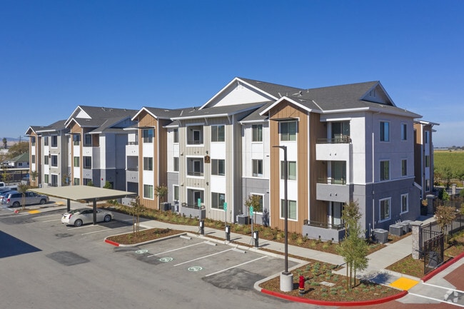
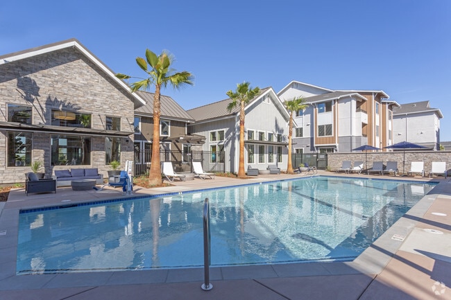
Property Record
3580 W Grant Line Rd, Tracy, CA 95304


Save to a Folder
{{folder.Name}}
{{folder.ListingIds.length}} Properties
{{folder.ListingIds.length}} Property
Create a New Folder
Property Detail
3580 W Grant Line Rd
209-270-34
16-FM PT 209-270-30 PT TO 35 PER 15059463/15059464
Multifamilydwelling
San Joaquin
PUD1
California
B and X Area of moderate flood hazard, usually the area between the limits of the 100-year and 500-year floods.
8.96 AC
2025
Tracy
2025
Stockton/Modesto
005225
Stockton-Lodi, CA
22,726 SF
NEARBY LISTINGS FOR SALE OR LEASE
-
-
View all Tracy listings for sale on LoopNet.com
DEMOGRAPHICS near 3580 W Grant Line Rd
1 mile
3 mile
5 mile
2025 Total Population
6,051
50,866
131,811
2030 Population
6,378
53,042
138,633
Pop Growth 2025-2030
+ 5.40%
+ 4.28%
+ 5.18%
Average Age
37
38
37
2025 Total Households
1,876
15,246
38,774
HH Growth 2025-2030
+ 5.49%
+ 4.38%
+ 5.23%
Median Household Inc
$120,577
$118,683
$130,173
Avg Household Size
3.10
3.30
3.30
2025 Avg HH Vehicles
2.00
3.00
3.00
Median Home Value
$801,777
$721,350
$756,610
Median Year Built
2009
1994
1999
Nearby Places
Map Layers
Map Styles
 Street
 Aerial
Layers
 Traffic
 Biking
Places
Listings with unknown addresses are not visible on the map
- Restaurants
- Banks
- Shops
- Fitness
- Groceries
PUBLIC TRANSPORTATION
COMMUTER RAIL
Tracy Station (ACE Train - Altamont Corridor Express)
Drive
Walk
Distance
Tracy Station (ACE Train - Altamont Corridor Express)
11 min
6.5 mi
AIRPORT
Stockton Metro
Drive
Walk
Distance
Stockton Metro
27 min
20.9 mi
Freight Ports
Port of Stockton
Drive
Walk
Distance
Port of Stockton
29 min
24.2 mi
Nearby Properties
Address
Land Use
TOTAL SIZE
Lot Size
Zoning
Address
Land Use
TOTAL SIZE
Lot Size
Zoning
641,000 SF
378.88 AC
Address
Land Use
TOTAL SIZE
Lot Size
Zoning
1,120,082 SF
94.93 AC
AG40
Address
Land Use
TOTAL SIZE
Lot Size
Zoning
663,568 SF
158.06 AC
Address
Land Use
TOTAL SIZE
Lot Size
Zoning
1,034,066 SF
61.05 AC
Address
Land Use
TOTAL SIZE
Lot Size
Zoning
653,447 SF
66.62 AC
IG
Address
Land Use
TOTAL SIZE
Lot Size
Zoning
1,601 SF
17.08 AC
PUD1
Address
Land Use
TOTAL SIZE
Lot Size
Zoning
3.77 AC
Address
Land Use
TOTAL SIZE
Lot Size
Zoning
483,967 SF
77.75 AC
Address
Land Use
TOTAL SIZE
Lot Size
Zoning
726,000 SF
32.29 AC
M1
Address
Land Use
TOTAL SIZE
Lot Size
Zoning
10.15 AC
PUD1
Address
Land Use
TOTAL SIZE
Lot Size
Zoning
490,000 SF
46 AC
IG
Address
Land Use
TOTAL SIZE
Lot Size
Zoning
9,327 SF
12.06 AC
Address
Land Use
TOTAL SIZE
Lot Size
Zoning
575,167 SF
46.44 AC
Address
Land Use
TOTAL SIZE
Lot Size
Zoning
49,264 SF
9 AC
Address
Land Use
TOTAL SIZE
Lot Size
Zoning
148,663 SF
16.37 AC
Address
Land Use
TOTAL SIZE
Lot Size
Zoning
225,000 SF
11.13 AC
M
Address
Land Use
TOTAL SIZE
Lot Size
Zoning
95.54 AC
Address
Land Use
TOTAL SIZE
Lot Size
Zoning
64,582 SF
3.10 AC
Address
Land Use
TOTAL SIZE
Lot Size
Zoning
190,388 SF
13.50 AC
Address
Land Use
TOTAL SIZE
Lot Size
Zoning
1,347 SF
4.96 AC
Address
Land Use
TOTAL SIZE
Lot Size
Zoning
55,576 SF
2.65 AC
Address
Land Use
TOTAL SIZE
Lot Size
Zoning
109,438 SF
6.23 AC
Address
Land Use
TOTAL SIZE
Lot Size
Zoning
13,990 SF
8.30 AC
Address
Land Use
TOTAL SIZE
Lot Size
Zoning
103 AC
AG40
Address
Land Use
TOTAL SIZE
Lot Size
Zoning
47,064 SF
2.36 AC
GC
Address
Land Use
TOTAL SIZE
Lot Size
Zoning
112,850 SF
8.11 AC
Address
Land Use
TOTAL SIZE
Lot Size
Zoning
11,375 SF
4.51 AC
Address
Land Use
TOTAL SIZE
Lot Size
Zoning
11.15 AC
The World's #1 Commercial Real Estate Marketplace
Connect with us
© 2026 CoStar Group
The information above has been obtained from sources believed reliable. While we do not doubt its accuracy we have not verified it and make no guarantee, warranty or representation about it. It is your responsibility to independently confirm its accuracy and completeness. Any projections, opinions, assumptions, or estimates used are for example only and do not represent the current or future performance of the property. The value of this transaction to you depends on tax and other factors which should be evaluated by your tax, financial, and legal advisors. You and your advisors should conduct a careful, independent investigation of the property to determine to your satisfaction the suitability of the property for your needs.