Property Record
3581 Route 302, Lisbon, NH 03585
NEARBY LISTINGS FOR SALE OR LEASE
-
-
View all Lisbon listings for sale on LoopNet.com
Property Detail
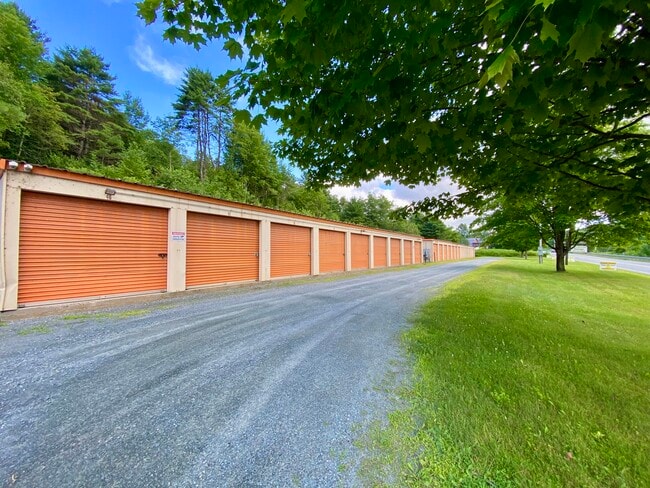
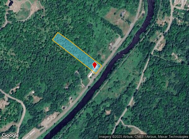
3581 Route 302
LSBN-000033R-000001-A000000
Grafton
Commercialnec
New Hampshire
X
a
33009C0115E
7.27 AC
2024
Concord/New Hampshire North Area
2024
Other Market Areas
960300
Claremont-Lebanon, NH-VT
2,700 SF
DEMOGRAPHICS near 3581 Route 302
1 Mile
3 Mile
5 Mile
2024 Total Population
167
1,245
8,072
2029 Population
181
1,351
8,706
Pop Growth 2024-2029
+ 8.38%
+ 8.51%
+ 7.85%
Average Age
44
47
46
2024 Total Households
72
534
3,730
HH Growth 2024-2029
+ 9.72%
+ 9.18%
+ 8.47%
Median Household Inc
$63,750
$76,766
$60,833
Avg Household Size
2.30
2.30
2.10
2024 Avg HH Vehicles
2.00
2.00
1.00
Median Home Value
$215,384
$324,762
$306,017
Median Year Built
1974
1978
1967
Nearby Places
Map Layers
Map Styles
 Street
 Aerial
- Restaurants
- Banks
- Shops
- Fitness
- Groceries
SALE & LEASE HISTORY
LISTING DATE
SALE/LEASE

Aug 04, 2025
For Sale
Nearby Properties
Address
Land Use
TOTAL SIZE
Lot Size
Zoning
Address
Land Use
TOTAL SIZE
Lot Size
Zoning
141,695 SF
16.60 AC
C-1
Address
Land Use
TOTAL SIZE
Lot Size
Zoning
104,134 SF
32.13 AC
C-1
Address
Land Use
TOTAL SIZE
Lot Size
Zoning
96,456 SF
19.30 AC
C-1
Address
Land Use
TOTAL SIZE
Lot Size
Zoning
105,100 SF
7.82 AC
I
Address
Land Use
TOTAL SIZE
Lot Size
Zoning
55,196 SF
9 AC
C-1
Address
Land Use
TOTAL SIZE
Lot Size
Zoning
49,266 SF
21.07 AC
I
Address
Land Use
TOTAL SIZE
Lot Size
Zoning
57,673 SF
4.55 AC
R-1
Address
Land Use
TOTAL SIZE
Lot Size
Zoning
118,756 SF
23.30 AC
I
Address
Land Use
TOTAL SIZE
Lot Size
Zoning
16,080 SF
4.23 AC
I
Address
Land Use
TOTAL SIZE
Lot Size
Zoning
77,490 SF
19.10 AC
I
Address
Land Use
TOTAL SIZE
Lot Size
Zoning
62,400 SF
6.30 AC
C-1
Address
Land Use
TOTAL SIZE
Lot Size
Zoning
4,800 SF
29.34 AC
R-1
Address
Land Use
TOTAL SIZE
Lot Size
Zoning
38,764 SF
7.80 AC
C-1
Address
Land Use
TOTAL SIZE
Lot Size
Zoning
23,992 SF
43.30 AC
C-1
Address
Land Use
TOTAL SIZE
Lot Size
Zoning
4.50 AC
R-2
Address
Land Use
TOTAL SIZE
Lot Size
Zoning
79,282 SF
16.26 AC
I
Address
Land Use
TOTAL SIZE
Lot Size
Zoning
35,574 SF
4.40 AC
I
Address
Land Use
TOTAL SIZE
Lot Size
Zoning
16,741 SF
4.97 AC
C-1
Address
Land Use
TOTAL SIZE
Lot Size
Zoning
4,814 SF
2.30 AC
C-1
Address
Land Use
TOTAL SIZE
Lot Size
Zoning
8,887 SF
32.40 AC
DIST D
Address
Land Use
TOTAL SIZE
Lot Size
Zoning
5,044 SF
2.85 AC
C-1
Address
Land Use
TOTAL SIZE
Lot Size
Zoning
12,810 SF
3.98 AC
C-1
Address
Land Use
TOTAL SIZE
Lot Size
Zoning
7,716 SF
11.16 AC
DIST A
Address
Land Use
TOTAL SIZE
Lot Size
Zoning
5,796 SF
2.38 AC
C-1
Address
Land Use
TOTAL SIZE
Lot Size
Zoning
26,047 SF
3 AC
I
Address
Land Use
TOTAL SIZE
Lot Size
Zoning
4,131 SF
14.70 AC
DIST A
Address
Land Use
TOTAL SIZE
Lot Size
Zoning
10,500 SF
3.50 AC
C-1
Address
Land Use
TOTAL SIZE
Lot Size
Zoning
6,400 SF
13.65 AC
C-1
Address
Land Use
TOTAL SIZE
Lot Size
Zoning
5,582 SF
68.80 AC
RR1RUR
Address
Land Use
TOTAL SIZE
Lot Size
Zoning
13,884 SF
2 AC
C-1
The World's #1 Commercial Real Estate Marketplace
Connect with us
© 2026 CoStar Group
The information above has been obtained from sources believed reliable. While we do not doubt its accuracy we have not verified it and make no guarantee, warranty or representation about it. It is your responsibility to independently confirm its accuracy and completeness. Any projections, opinions, assumptions, or estimates used are for example only and do not represent the current or future performance of the property. The value of this transaction to you depends on tax and other factors which should be evaluated by your tax, financial, and legal advisors. You and your advisors should conduct a careful, independent investigation of the property to determine to your satisfaction the suitability of the property for your needs.