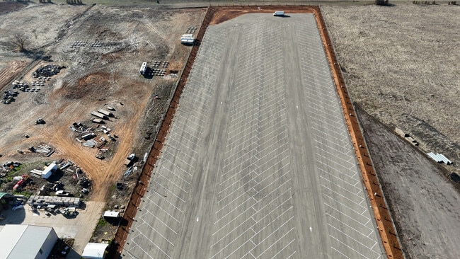
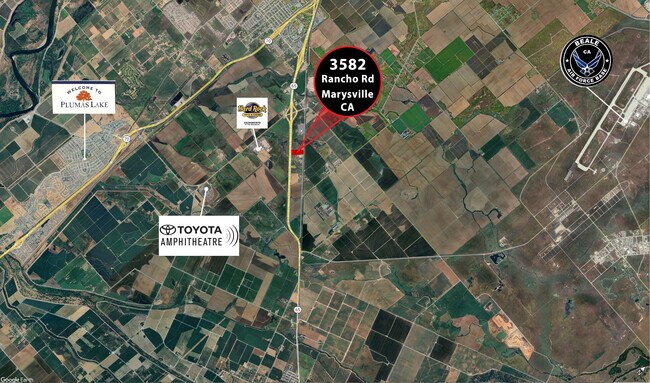
Property Record
3582 Rancho Rd, Marysville, CA 95901

Property Detail
3582 Rancho Rd
014-280-070-000
P-1 PM-88-42
Parkinglot
YUBA
M-1
California
C and X Area of minimal flood hazard, usually depicted on FIRMs as above the 500-year flood level.
10 AC
2024
Yuba County
2025
Sacramento
040202
Yuba City, CA
NEARBY LISTINGS FOR SALE OR LEASE
-
-
View all Marysville listings for sale on LoopNet.com
DEMOGRAPHICS near 3582 Rancho Rd
1 mile
3 mile
5 mile
2025 Total Population
52
5,886
35,466
2030 Population
55
6,259
38,011
Pop Growth 2025-2030
+ 5.77%
+ 6.34%
+ 7.18%
Average Age
38
36
36
2025 Total Households
18
1,829
10,783
HH Growth 2025-2030
+ 5.56%
+ 6.51%
+ 7.43%
Median Household Inc
$81,250
$84,153
$95,088
Avg Household Size
2.80
3.10
3.20
2025 Avg HH Vehicles
2.00
2.00
2.00
Median Home Value
$425,000
$330,810
$427,472
Median Year Built
1992
1980
2001
Nearby Places
Map Layers
Map Styles
 Street
 Aerial
Layers
 Traffic
 Biking
Places
Listings with unknown addresses are not visible on the map
- Restaurants
- Banks
- Shops
- Fitness
- Groceries
PUBLIC TRANSPORTATION
AIRPORT
Sacramento International
Drive
Walk
Distance
Sacramento International
46 min
35.4 mi
Freight Ports
Port of Stockton
Drive
Walk
Distance
Port of Stockton
98 min
83.8 mi
SALE & LEASE HISTORY
LISTING DATE
SALE/LEASE

Oct 03, 2016
For Sale
May 21, 2021
For Sale
Aug 30, 2024
For Sale
Nearby Properties
Address
Land Use
TOTAL SIZE
Lot Size
Zoning
Address
Land Use
TOTAL SIZE
Lot Size
Zoning
90 AC
AE-80
Address
Land Use
TOTAL SIZE
Lot Size
Zoning
140,358 SF
199 AC
AE-80
Address
Land Use
TOTAL SIZE
Lot Size
Zoning
23,484 SF
478.18 AC
AE-80
Address
Land Use
TOTAL SIZE
Lot Size
Zoning
470.07 AC
Address
Land Use
TOTAL SIZE
Lot Size
Zoning
593 AC
AE-80
Address
Land Use
TOTAL SIZE
Lot Size
Zoning
96,260 SF
3.40 AC
RRE
Address
Land Use
TOTAL SIZE
Lot Size
Zoning
77,696 SF
4 AC
R-02
Address
Land Use
TOTAL SIZE
Lot Size
Zoning
8,883 SF
45.03 AC
M-1
Address
Land Use
TOTAL SIZE
Lot Size
Zoning
207.05 AC
Address
Land Use
TOTAL SIZE
Lot Size
Zoning
90,931 SF
589 AC
AE-80
Address
Land Use
TOTAL SIZE
Lot Size
Zoning
3,440 SF
104.04 AC
M-1
Address
Land Use
TOTAL SIZE
Lot Size
Zoning
112,919 SF
91 AC
AE-80
Address
Land Use
TOTAL SIZE
Lot Size
Zoning
71.26 AC
M-1
Address
Land Use
TOTAL SIZE
Lot Size
Zoning
4,800 SF
1.48 AC
C
Address
Land Use
TOTAL SIZE
Lot Size
Zoning
11,040 SF
387.50 AC
Address
Land Use
TOTAL SIZE
Lot Size
Zoning
6,154 SF
622.78 AC
AE-80
Address
Land Use
TOTAL SIZE
Lot Size
Zoning
37.23 AC
SP
Address
Land Use
TOTAL SIZE
Lot Size
Zoning
109.30 AC
AE-80
Address
Land Use
TOTAL SIZE
Lot Size
Zoning
210.72 AC
AE-80
Address
Land Use
TOTAL SIZE
Lot Size
Zoning
31,200 SF
10 AC
M-1
Address
Land Use
TOTAL SIZE
Lot Size
Zoning
4,948 SF
305 AC
AE-80
Address
Land Use
TOTAL SIZE
Lot Size
Zoning
122,571 SF
197 AC
AE-80
Address
Land Use
TOTAL SIZE
Lot Size
Zoning
9,100 SF
1.20 AC
C
Address
Land Use
TOTAL SIZE
Lot Size
Zoning
312.50 AC
AE-80
Address
Land Use
TOTAL SIZE
Lot Size
Zoning
36,700 SF
17.29 AC
Address
Land Use
TOTAL SIZE
Lot Size
Zoning
1,680 SF
522.79 AC
Address
Land Use
TOTAL SIZE
Lot Size
Zoning
533 AC
AE-80
Address
Land Use
TOTAL SIZE
Lot Size
Zoning
31.26 AC
RRE
The World's #1 Commercial Real Estate Marketplace
Connect with us
© 2026 CoStar Group
The information above has been obtained from sources believed reliable. While we do not doubt its accuracy we have not verified it and make no guarantee, warranty or representation about it. It is your responsibility to independently confirm its accuracy and completeness. Any projections, opinions, assumptions, or estimates used are for example only and do not represent the current or future performance of the property. The value of this transaction to you depends on tax and other factors which should be evaluated by your tax, financial, and legal advisors. You and your advisors should conduct a careful, independent investigation of the property to determine to your satisfaction the suitability of the property for your needs.