Property Record
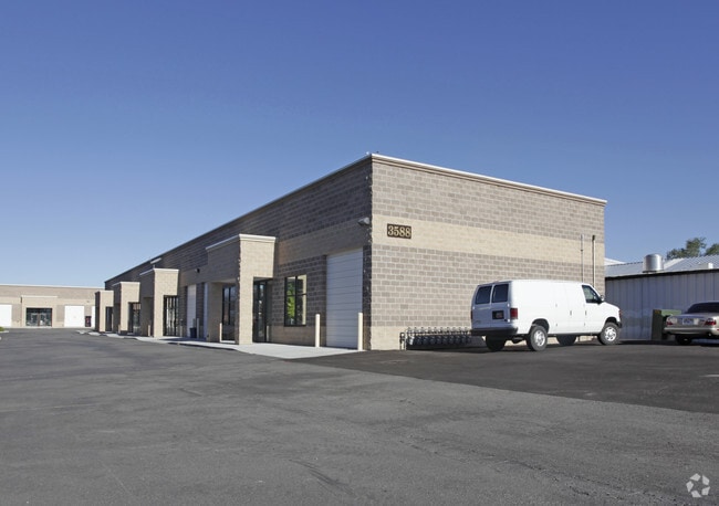
3584 S 1950 W, West Valley City, UT 84119

Current Lease Availabilities
NEARBY LISTINGS FOR SALE OR LEASE
Property Detail
3584 S 1950 W
15-34-105-014-0000
Kda Industrial Park Condo
Industrialcondominium
BLDG B, UNIT 1, KDA INDUSTRIAL PARK CONDO AMD. 9628-5967 10154-1699 10540-9467 10545-9522 10922-5310 11080-5025
X
Salt Lake
49035C0280E
Utah
2024
0.01 AC
2025
West Valley
113314
Salt Lake City
1,830 SF
Salt Lake City, UT
DEMOGRAPHICS near 3584 S 1950 W
1 Mile
3 Mile
5 Mile
2024 Total Population
22,246
124,068
352,706
2029 Population
22,380
125,338
357,064
Pop Growth 2024-2029
+ 0.60%
+ 1.02%
+ 1.24%
Average Age
35
36
37
2024 Total Households
7,779
40,778
122,949
HH Growth 2024-2029
+ 0.86%
+ 1.12%
+ 1.31%
Median Household Inc
$57,350
$64,056
$66,861
Avg Household Size
2.70
2.90
2.70
2024 Avg HH Vehicles
2.00
2.00
2.00
Median Home Value
$274,539
$330,105
$360,964
Median Year Built
1987
1982
1978
Nearby Places
Map Layers
Map Styles
 Street
 Aerial
- Restaurants
- Banks
- Shops
- Fitness
- Groceries
PUBLIC TRANSPORTATION
TRANSIT/SUBWAY
Decker Lake Station (Green Line - Utah Transit Authority (UTA))
DRIVE
WALK
Distance
Decker Lake Station (Green Line - Utah Transit Authority (UTA))
3 min
18 min
0.9 mi
COMMUTER RAIL
North Temple Station (FrontRunner - Utah Transit Authority (UTA))
DRIVE
WALK
Distance
North Temple Station (FrontRunner - Utah Transit Authority (UTA))
14 min
8.1 mi
Warm Springs Relief Point (FrontRunner - Utah Transit Authority (UTA))
DRIVE
WALK
Distance
Warm Springs Relief Point (FrontRunner - Utah Transit Authority (UTA))
16 min
9.4 mi
AIRPORT
Salt Lake City International
DRIVE
WALK
Distance
Salt Lake City International
14 min
8.9 mi
Freight Ports
Port of Stockton
DRIVE
WALK
Distance
Port of Stockton
713 min
695.5 mi
Nearby Properties
Address
Land Use
TOTAL SIZE
Lot Size
Zoning
Address
Land Use
TOTAL SIZE
Lot Size
Zoning
488,509 SF
36.03 AC
FLEX
Address
Land Use
TOTAL SIZE
Lot Size
Zoning
35,897 SF
28.61 AC
RM-12
Address
Land Use
TOTAL SIZE
Lot Size
Zoning
828,269 SF
9.06 AC
RM
Address
Land Use
TOTAL SIZE
Lot Size
Zoning
521,964 SF
3.23 AC
T-O-D
Address
Land Use
TOTAL SIZE
Lot Size
Zoning
673,062 SF
15.84 AC
RM
Address
Land Use
TOTAL SIZE
Lot Size
Zoning
185,436 SF
25.23 AC
RM
Address
Land Use
TOTAL SIZE
Lot Size
Zoning
382,335 SF
63.87 AC
OS
Address
Land Use
TOTAL SIZE
Lot Size
Zoning
95,854 SF
15.42 AC
CC
Address
Land Use
TOTAL SIZE
Lot Size
Zoning
322,076 SF
16.32 AC
PL
Address
Land Use
TOTAL SIZE
Lot Size
Zoning
195,790 SF
14.32 AC
RM
Address
Land Use
TOTAL SIZE
Lot Size
Zoning
178,102 SF
15.95 AC
C-3
Address
Land Use
TOTAL SIZE
Lot Size
Zoning
76,096 SF
17.30 AC
RM
Address
Land Use
TOTAL SIZE
Lot Size
Zoning
84,870 SF
9.76 AC
MPMU
Address
Land Use
TOTAL SIZE
Lot Size
Zoning
217,700 SF
52.59 AC
FLEX
Address
Land Use
TOTAL SIZE
Lot Size
Zoning
56,867 SF
5.33 AC
MIXED
Address
Land Use
TOTAL SIZE
Lot Size
Zoning
401,887 SF
3.51 AC
RM
Address
Land Use
TOTAL SIZE
Lot Size
Zoning
63,758 SF
13.93 AC
RM
Address
Land Use
TOTAL SIZE
Lot Size
Zoning
138,180 SF
2.06 AC
RM-12
Address
Land Use
TOTAL SIZE
Lot Size
Zoning
80,985 SF
19.18 AC
RM
Address
Land Use
TOTAL SIZE
Lot Size
Zoning
29.13 AC
C-2
Address
Land Use
TOTAL SIZE
Lot Size
Zoning
289,725 SF
8.42 AC
1108
Address
Land Use
TOTAL SIZE
Lot Size
Zoning
116,268 SF
8.07 AC
RMF-45
Address
Land Use
TOTAL SIZE
Lot Size
Zoning
89,239 SF
14.78 AC
RM
Address
Land Use
TOTAL SIZE
Lot Size
Zoning
137,209 SF
38.90 AC
FLEX
Address
Land Use
TOTAL SIZE
Lot Size
Zoning
137,697 SF
5.92 AC
C-2/ZC
Address
Land Use
TOTAL SIZE
Lot Size
Zoning
436,875 SF
26.95 AC
M-1
Address
Land Use
TOTAL SIZE
Lot Size
Zoning
381,105 SF
2.88 AC
CC
Address
Land Use
TOTAL SIZE
Lot Size
Zoning
750,887 SF
28 AC
M1
Address
Land Use
TOTAL SIZE
Lot Size
Zoning
57,772 SF
8.09 AC
MU
Address
Land Use
TOTAL SIZE
Lot Size
Zoning
304,366 SF
2.71 AC
M
The World's #1 Commercial Real Estate Marketplace
Connect with us
© 2025 CoStar Group
The information above has been obtained from sources believed reliable. While we do not doubt its accuracy we have not verified it and make no guarantee, warranty or representation about it. It is your responsibility to independently confirm its accuracy and completeness. Any projections, opinions, assumptions, or estimates used are for example only and do not represent the current or future performance of the property. The value of this transaction to you depends on tax and other factors which should be evaluated by your tax, financial, and legal advisors. You and your advisors should conduct a careful, independent investigation of the property to determine to your satisfaction the suitability of the property for your needs.