Property Record
3585 W Beechwood Ave, Fresno, CA 93711
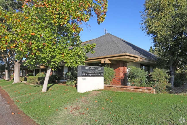

This Property Is For Sale
Current Lease Availabilities
NEARBY LISTINGS FOR SALE OR LEASE
Property Detail
3585 W Beechwood Ave
501-170-12S
Parcel Map No 88 44
Officebuilding
1UR RT PAR IN BLKS B & C PAR A BK 48 PGS 36-41
X
Fresno
06019C1555H
California
2025
0.30 AC
2025
North Fresno
004208
Fresno
2,672 SF
Fresno, CA
DEMOGRAPHICS near 3585 W Beechwood Ave
1 Mile
3 Mile
5 Mile
2024 Total Population
11,241
85,706
213,056
2029 Population
11,462
87,614
217,644
Pop Growth 2024-2029
+ 1.97%
+ 2.23%
+ 2.15%
Average Age
43
39
37
2024 Total Households
4,457
31,191
74,188
HH Growth 2024-2029
+ 1.93%
+ 2.23%
+ 2.13%
Median Household Inc
$85,373
$77,976
$69,375
Avg Household Size
2.50
2.70
2.80
2024 Avg HH Vehicles
2.00
2.00
2.00
Median Home Value
$447,267
$377,176
$343,787
Median Year Built
1986
1987
1981
Nearby Places
Map Layers
Map Styles
 Street
 Aerial
- Restaurants
- Banks
- Shops
- Fitness
- Groceries
PUBLIC TRANSPORTATION
AIRPORT
Fresno Yosemite International
DRIVE
WALK
Distance
Fresno Yosemite International
21 min
12.3 mi
Nearby Properties
Address
Land Use
TOTAL SIZE
Lot Size
Zoning
Address
Land Use
TOTAL SIZE
Lot Size
Zoning
477,820 SF
18.78 AC
RA
Address
Land Use
TOTAL SIZE
Lot Size
Zoning
412,974 SF
29.02 AC
R2
Address
Land Use
TOTAL SIZE
Lot Size
Zoning
197,659 SF
11.80 AC
CC
Address
Land Use
TOTAL SIZE
Lot Size
Zoning
423,568 SF
32.25 AC
R2
Address
Land Use
TOTAL SIZE
Lot Size
Zoning
234,370 SF
23 AC
SPLIT
Address
Land Use
TOTAL SIZE
Lot Size
Zoning
278,502 SF
19.42 AC
SPLIT
Address
Land Use
TOTAL SIZE
Lot Size
Zoning
82,970 SF
8.19 AC
CR
Address
Land Use
TOTAL SIZE
Lot Size
Zoning
178,900 SF
11.68 AC
CP
Address
Land Use
TOTAL SIZE
Lot Size
Zoning
232,183 SF
18.32 AC
R2A
Address
Land Use
TOTAL SIZE
Lot Size
Zoning
54,758 SF
8 AC
AE5
Address
Land Use
TOTAL SIZE
Lot Size
Zoning
176,228 SF
10.17 AC
R2
Address
Land Use
TOTAL SIZE
Lot Size
Zoning
150,437 SF
14.72 AC
SPLIT
Address
Land Use
TOTAL SIZE
Lot Size
Zoning
139,072 SF
11.15 AC
C3
Address
Land Use
TOTAL SIZE
Lot Size
Zoning
56,331 SF
5.31 AC
CM
Address
Land Use
TOTAL SIZE
Lot Size
Zoning
83,026 SF
5.02 AC
RM1
Address
Land Use
TOTAL SIZE
Lot Size
Zoning
124,055 SF
9.35 AC
R2
Address
Land Use
TOTAL SIZE
Lot Size
Zoning
92,279 SF
0.01 AC
CM
Address
Land Use
TOTAL SIZE
Lot Size
Zoning
124,828 SF
5.70 AC
C2
Address
Land Use
TOTAL SIZE
Lot Size
Zoning
46,938 SF
9.25 AC
C6
Address
Land Use
TOTAL SIZE
Lot Size
Zoning
83,800 SF
4.04 AC
R2
Address
Land Use
TOTAL SIZE
Lot Size
Zoning
45,226 SF
2.77 AC
C2
Address
Land Use
TOTAL SIZE
Lot Size
Zoning
38,016 SF
3.18 AC
CM
Address
Land Use
TOTAL SIZE
Lot Size
Zoning
45,944 SF
2.30 AC
CP
Address
Land Use
TOTAL SIZE
Lot Size
Zoning
53,033 SF
7.09 AC
C1
Address
Land Use
TOTAL SIZE
Lot Size
Zoning
111,149 SF
8.22 AC
RM1
Address
Land Use
TOTAL SIZE
Lot Size
Zoning
128,386 SF
8.30 AC
R2
Address
Land Use
TOTAL SIZE
Lot Size
Zoning
57,445 SF
5.81 AC
Address
Land Use
TOTAL SIZE
Lot Size
Zoning
111,285 SF
10 AC
R1
Address
Land Use
TOTAL SIZE
Lot Size
Zoning
28,247 SF
3.47 AC
CM
Address
Land Use
TOTAL SIZE
Lot Size
Zoning
182,722 SF
13.29 AC
R2
The World's #1 Commercial Real Estate Marketplace
Connect with us
© 2025 CoStar Group
The information above has been obtained from sources believed reliable. While we do not doubt its accuracy we have not verified it and make no guarantee, warranty or representation about it. It is your responsibility to independently confirm its accuracy and completeness. Any projections, opinions, assumptions, or estimates used are for example only and do not represent the current or future performance of the property. The value of this transaction to you depends on tax and other factors which should be evaluated by your tax, financial, and legal advisors. You and your advisors should conduct a careful, independent investigation of the property to determine to your satisfaction the suitability of the property for your needs.