Property Record
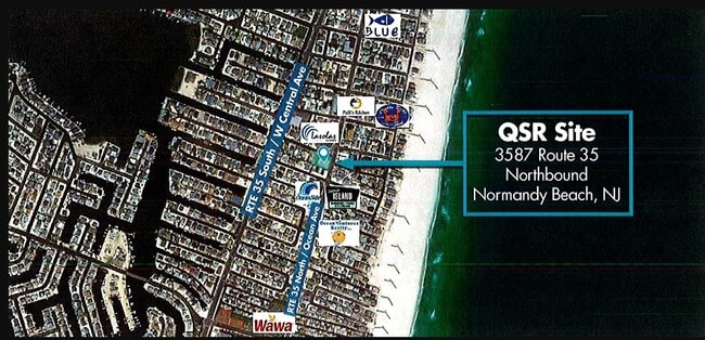
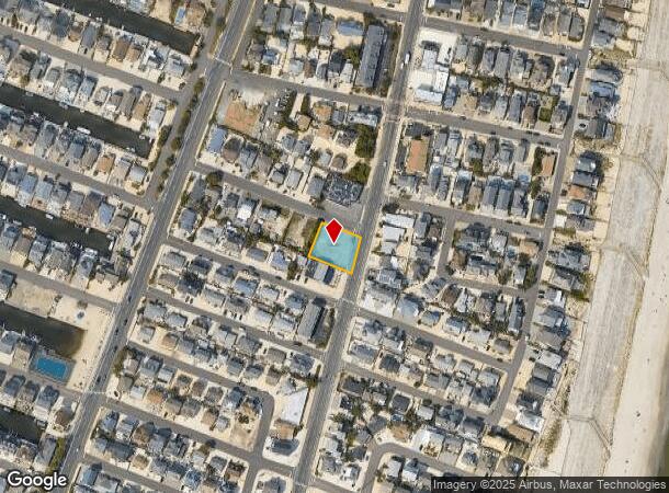
3587 Route 35 N, Lavallette, NJ 08735
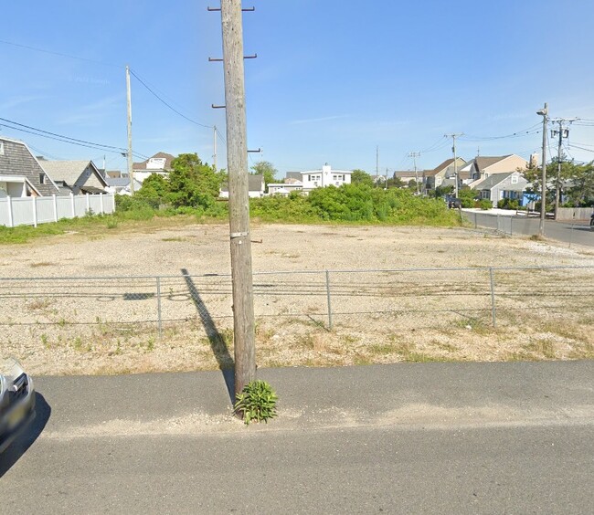
This Property Is For Sale
NEARBY LISTINGS FOR SALE OR LEASE
-
-
View all Lavallette listings for sale on LoopNet.com
Property Detail
3587 Route 35 N
New York-Jersey City-White Plains, NY-NJ
100X110
08-00918-0000-00008
Ocean
Vacantlandnec
New Jersey
AE
8
34029C0327F
0.25 AC
2024
Ocean County
2025
Northern New Jersey
722500
DEMOGRAPHICS near 3587 Route 35 N
1 Mile
3 Mile
5 Mile
2024 Total Population
6,230
21,207
79,926
2029 Population
7,531
24,837
88,738
Pop Growth 2024-2029
+ 20.88%
+ 17.12%
+ 11.03%
Average Age
58
53
45
2024 Total Households
3,373
10,390
33,726
HH Growth 2024-2029
+ 20.81%
+ 17.35%
+ 11.42%
Median Household Inc
$61,448
$91,293
$91,745
Avg Household Size
1.80
2.00
2.30
2024 Avg HH Vehicles
2.00
2.00
2.00
Median Home Value
$684,588
$666,026
$434,936
Median Year Built
1976
1980
1974
Nearby Places
Map Layers
Map Styles
 Street
 Aerial
- Restaurants
- Banks
- Shops
- Fitness
- Groceries
PUBLIC TRANSPORTATION
COMMUTER RAIL
Bay Head (North Jersey Coast Line - NJ Transit Commuter Rail (NJ Transit))
DRIVE
WALK
Distance
Bay Head (North Jersey Coast Line - NJ Transit Commuter Rail (NJ Transit))
11 min
5.6 mi
Point Pleasant Beach (North Jersey Coast Line - NJ Transit Commuter Rail (NJ Transit))
DRIVE
WALK
Distance
Point Pleasant Beach (North Jersey Coast Line - NJ Transit Commuter Rail (NJ Transit))
13 min
6.9 mi
Freight Ports
New York Container Terminal
DRIVE
WALK
Distance
New York Container Terminal
77 min
56.3 mi
Nearby Properties
Address
Land Use
TOTAL SIZE
Lot Size
Zoning
Address
Land Use
TOTAL SIZE
Lot Size
Zoning
117 AC
RR1
Address
Land Use
TOTAL SIZE
Lot Size
Zoning
2.67 AC
SMF
Address
Land Use
TOTAL SIZE
Lot Size
Zoning
Address
Land Use
TOTAL SIZE
Lot Size
Zoning
29,422 SF
1.30 AC
Address
Land Use
TOTAL SIZE
Lot Size
Zoning
1.29 AC
Address
Land Use
TOTAL SIZE
Lot Size
Zoning
1,677 SF
3 AC
R-3A
Address
Land Use
TOTAL SIZE
Lot Size
Zoning
10,003 SF
0.32 AC
PU
Address
Land Use
TOTAL SIZE
Lot Size
Zoning
1.23 AC
SMF
Address
Land Use
TOTAL SIZE
Lot Size
Zoning
1,679 SF
2.17 AC
SMF
Address
Land Use
TOTAL SIZE
Lot Size
Zoning
1.22 AC
SMF
Address
Land Use
TOTAL SIZE
Lot Size
Zoning
Address
Land Use
TOTAL SIZE
Lot Size
Zoning
2,268 SF
6.91 AC
R75
Address
Land Use
TOTAL SIZE
Lot Size
Zoning
Address
Land Use
TOTAL SIZE
Lot Size
Zoning
2.76 AC
Address
Land Use
TOTAL SIZE
Lot Size
Zoning
1.28 AC
R-1
Address
Land Use
TOTAL SIZE
Lot Size
Zoning
13,168 SF
0.66 AC
Address
Land Use
TOTAL SIZE
Lot Size
Zoning
5,289 SF
2.89 AC
Address
Land Use
TOTAL SIZE
Lot Size
Zoning
5,624 SF
1.28 AC
GB
Address
Land Use
TOTAL SIZE
Lot Size
Zoning
192 SF
0.71 AC
GB
Address
Land Use
TOTAL SIZE
Lot Size
Zoning
16.90 AC
B2
Address
Land Use
TOTAL SIZE
Lot Size
Zoning
14,278 SF
0.72 AC
GBMF
Address
Land Use
TOTAL SIZE
Lot Size
Zoning
1.33 AC
R75
Address
Land Use
TOTAL SIZE
Lot Size
Zoning
0.87 AC
R-1
Address
Land Use
TOTAL SIZE
Lot Size
Zoning
0.84 AC
R-1
Address
Land Use
TOTAL SIZE
Lot Size
Zoning
0.85 AC
R-1
Address
Land Use
TOTAL SIZE
Lot Size
Zoning
6,614 SF
0.67 AC
R-1
Address
Land Use
TOTAL SIZE
Lot Size
Zoning
2.70 AC
R5
Address
Land Use
TOTAL SIZE
Lot Size
Zoning
1.26 AC
MF16
Address
Land Use
TOTAL SIZE
Lot Size
Zoning
1,344 SF
0.45 AC
Address
Land Use
TOTAL SIZE
Lot Size
Zoning
0.34 AC
R-3A
The World's #1 Commercial Real Estate Marketplace
Connect with us
© 2025 CoStar Group
The information above has been obtained from sources believed reliable. While we do not doubt its accuracy we have not verified it and make no guarantee, warranty or representation about it. It is your responsibility to independently confirm its accuracy and completeness. Any projections, opinions, assumptions, or estimates used are for example only and do not represent the current or future performance of the property. The value of this transaction to you depends on tax and other factors which should be evaluated by your tax, financial, and legal advisors. You and your advisors should conduct a careful, independent investigation of the property to determine to your satisfaction the suitability of the property for your needs.