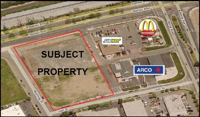
Property Record
3595 Utah St, Pleasanton, CA 94566
NEARBY LISTINGS FOR SALE OR LEASE
Property Detail
3595 Utah St
Oakland-Hayward-Berkeley, CA
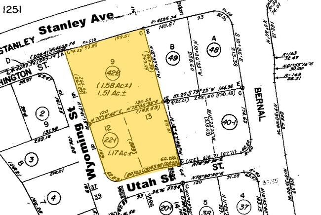
Parcel Map No 5814
946-4542-022-01
LOT: 00012 BLK: TR: 4401 ;LOT: 00013 BLK: TR: 4401
Commercialacreage
Alameda
X
California
06001C0336G
12
2024
1.17 AC
2025
Pleasanton
450741
East Bay/Oakland
DEMOGRAPHICS near 3595 Utah St
1 Mile
3 Mile
5 Mile
2024 Total Population
14,048
78,491
171,279
2029 Population
13,680
75,753
165,876
Pop Growth 2024-2029
(2.62%)
(3.49%)
(3.15%)
Average Age
43
41
40
2024 Total Households
5,371
27,928
59,139
HH Growth 2024-2029
(2.85%)
(3.73%)
(3.32%)
Median Household Inc
$151,679
$173,593
$168,680
Avg Household Size
2.60
2.80
2.80
2024 Avg HH Vehicles
2.00
2.00
2.00
Median Home Value
$1,063,032
$1,090,819
$1,057,281
Median Year Built
1982
1987
1988
Nearby Places
- Restaurants
- Banks
- Shops
- Fitness
- Groceries
PUBLIC TRANSPORTATION
COMMUTER RAIL
Pleasanton (Altamont Corridor Express - Altamont Commuter Express (ACE))
DRIVE
WALK
Distance
Pleasanton (Altamont Corridor Express - Altamont Commuter Express (ACE))
6 min
1.9 mi
DRIVE
WALK
Distance
6 min
1.9 mi
AIRPORT
Metro Oakland International
DRIVE
WALK
Distance
Metro Oakland International
34 min
24.3 mi
Norman Y Mineta San Jose International
DRIVE
WALK
Distance
Norman Y Mineta San Jose International
39 min
27.8 mi
San Francisco International
DRIVE
WALK
Distance
San Francisco International
54 min
38.8 mi
Freight Ports
Port of Oakland
DRIVE
WALK
Distance
Port of Oakland
38 min
28.8 mi
Nearby Properties
Address
Land Use
TOTAL SIZE
Lot Size
Zoning
Address
Land Use
TOTAL SIZE
Lot Size
Zoning
789,398 SF
57.91 AC
Address
Land Use
TOTAL SIZE
Lot Size
Zoning
713,970 SF
23.48 AC
Address
Land Use
TOTAL SIZE
Lot Size
Zoning
674,847 SF
31.27 AC
Address
Land Use
TOTAL SIZE
Lot Size
Zoning
438,210 SF
17.81 AC
Address
Land Use
TOTAL SIZE
Lot Size
Zoning
249,319 SF
14.72 AC
Address
Land Use
TOTAL SIZE
Lot Size
Zoning
386,609 SF
33.36 AC
Address
Land Use
TOTAL SIZE
Lot Size
Zoning
486,976 SF
11.96 AC
Address
Land Use
TOTAL SIZE
Lot Size
Zoning
690,205 SF
20.44 AC
Address
Land Use
TOTAL SIZE
Lot Size
Zoning
381,982 SF
17.54 AC
Address
Land Use
TOTAL SIZE
Lot Size
Zoning
196,986 SF
7 AC
Address
Land Use
TOTAL SIZE
Lot Size
Zoning
306,815 SF
8.28 AC
Address
Land Use
TOTAL SIZE
Lot Size
Zoning
646,841 SF
38.83 AC
Address
Land Use
TOTAL SIZE
Lot Size
Zoning
335,523 SF
7.23 AC
Address
Land Use
TOTAL SIZE
Lot Size
Zoning
393,931 SF
22.38 AC
Address
Land Use
TOTAL SIZE
Lot Size
Zoning
288,690 SF
0.10 AC
Address
Land Use
TOTAL SIZE
Lot Size
Zoning
367,734 SF
18.81 AC
Address
Land Use
TOTAL SIZE
Lot Size
Zoning
315,225 SF
10.13 AC
Address
Land Use
TOTAL SIZE
Lot Size
Zoning
300,597 SF
19.34 AC
Address
Land Use
TOTAL SIZE
Lot Size
Zoning
8,000 SF
58.49 AC
Address
Land Use
TOTAL SIZE
Lot Size
Zoning
294,940 SF
16.54 AC
Address
Land Use
TOTAL SIZE
Lot Size
Zoning
163,322 SF
10.93 AC
Address
Land Use
TOTAL SIZE
Lot Size
Zoning
30.26 AC
Address
Land Use
TOTAL SIZE
Lot Size
Zoning
13,826 SF
48.86 AC
Address
Land Use
TOTAL SIZE
Lot Size
Zoning
139,490 SF
7.37 AC
Address
Land Use
TOTAL SIZE
Lot Size
Zoning
311,783 SF
16.37 AC
Address
Land Use
TOTAL SIZE
Lot Size
Zoning
337,206 SF
11.84 AC
Address
Land Use
TOTAL SIZE
Lot Size
Zoning
366,452 SF
16.33 AC
Address
Land Use
TOTAL SIZE
Lot Size
Zoning
207,217 SF
18.72 AC
Address
Land Use
TOTAL SIZE
Lot Size
Zoning
296,722 SF
6.86 AC
Address
Land Use
TOTAL SIZE
Lot Size
Zoning
155,318 SF
7.57 AC
The World's #1 Commercial Real Estate Marketplace
Connect with us
© 2025 CoStar Group
The information above has been obtained from sources believed reliable. While we do not doubt its accuracy we have not verified it and make no guarantee, warranty or representation about it. It is your responsibility to independently confirm its accuracy and completeness. Any projections, opinions, assumptions, or estimates used are for example only and do not represent the current or future performance of the property. The value of this transaction to you depends on tax and other factors which should be evaluated by your tax, financial, and legal advisors. You and your advisors should conduct a careful, independent investigation of the property to determine to your satisfaction the suitability of the property for your needs.