Property Record
3597 12Th St, Wayland, MI 49348

Save to a Folder
{{folder.Name}}
{{folder.ListingIds.length}} Properties
{{folder.ListingIds.length}} Property
Create a New Folder
Property Detail
3597 12Th St
Holland, MI
COM NW COR OF SEC TH S 2 DEG 50'23 E 333' TH N 86 DEG 45'35 E 317.90' TO W'LY R/W US 131 TH N ALG SD R/W TO N LIN OF SEC TH W
24-006-001-12
ALLEGAN
Commercialnec
Michigan
B and X Area of moderate flood hazard, usually the area between the limits of the 100-year and 500-year floods.
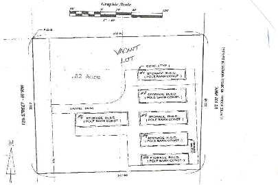
0.90 AC
2025
Outlying Allegan County
2026
West Michigan
030600
NEARBY LISTINGS FOR SALE OR LEASE
-
-
No Photo
-
View all Wayland listings for sale on LoopNet.com
DEMOGRAPHICS near 3597 12Th St
1 mile
3 mile
5 mile
2025 Total Population
2,836
6,982
16,688
2030 Population
2,906
7,077
16,759
Pop Growth 2025-2030
+ 2.47%
+ 1.36%
+ 0.43%
Average Age
39
38
38
2025 Total Households
1,136
2,622
5,955
HH Growth 2025-2030
+ 2.46%
+ 1.41%
+ 0.42%
Median Household Inc
$69,506
$76,415
$81,569
Avg Household Size
2.40
2.60
2.70
2025 Avg HH Vehicles
2.00
2.00
2.00
Median Home Value
$169,575
$215,918
$250,628
Median Year Built
1988
1986
1986
Nearby Places
Map Layers
Map Styles
 Street
 Aerial
Layers
 Traffic
 Biking
Places
Listings with unknown addresses are not visible on the map
- Restaurants
- Banks
- Shops
- Fitness
- Groceries
PUBLIC TRANSPORTATION
AIRPORT
Gerald R Ford International
Drive
Walk
Distance
Gerald R Ford International
33 min
22.9 mi
Freight Ports
Port Milwaukee
Drive
Walk
Distance
Port Milwaukee
299 min
256.4 mi
Nearby Properties
Address
Land Use
TOTAL SIZE
Lot Size
Zoning
Address
Land Use
TOTAL SIZE
Lot Size
Zoning
99,487 SF
14.18 AC
Address
Land Use
TOTAL SIZE
Lot Size
Zoning
64,863 SF
10.14 AC
Address
Land Use
TOTAL SIZE
Lot Size
Zoning
115,750 SF
60.34 AC
Address
Land Use
TOTAL SIZE
Lot Size
Zoning
60.53 AC
Address
Land Use
TOTAL SIZE
Lot Size
Zoning
69,034 SF
22.50 AC
Address
Land Use
TOTAL SIZE
Lot Size
Zoning
62,500 SF
18.89 AC
Address
Land Use
TOTAL SIZE
Lot Size
Zoning
81,396 SF
12.32 AC
Address
Land Use
TOTAL SIZE
Lot Size
Zoning
38,241 SF
2.33 AC
Address
Land Use
TOTAL SIZE
Lot Size
Zoning
70,748 SF
20.74 AC
Address
Land Use
TOTAL SIZE
Lot Size
Zoning
35,333 SF
50.49 AC
Address
Land Use
TOTAL SIZE
Lot Size
Zoning
170,318 SF
7.11 AC
Address
Land Use
TOTAL SIZE
Lot Size
Zoning
121,440 SF
8.89 AC
Address
Land Use
TOTAL SIZE
Lot Size
Zoning
41,595 SF
10.08 AC
Address
Land Use
TOTAL SIZE
Lot Size
Zoning
197.92 AC
Address
Land Use
TOTAL SIZE
Lot Size
Zoning
37,449 SF
7.38 AC
Address
Land Use
TOTAL SIZE
Lot Size
Zoning
17,903 SF
2.05 AC
Address
Land Use
TOTAL SIZE
Lot Size
Zoning
29,356 SF
2.49 AC
Address
Land Use
TOTAL SIZE
Lot Size
Zoning
7,104 SF
2.03 AC
Address
Land Use
TOTAL SIZE
Lot Size
Zoning
7,948 SF
4.91 AC
Address
Land Use
TOTAL SIZE
Lot Size
Zoning
71,798 SF
11.11 AC
Address
Land Use
TOTAL SIZE
Lot Size
Zoning
19,800 SF
40.83 AC
Address
Land Use
TOTAL SIZE
Lot Size
Zoning
9,584 SF
2.47 AC
Address
Land Use
TOTAL SIZE
Lot Size
Zoning
120 AC
Address
Land Use
TOTAL SIZE
Lot Size
Zoning
20,231 SF
4.27 AC
Address
Land Use
TOTAL SIZE
Lot Size
Zoning
1,680 SF
184.42 AC
Address
Land Use
TOTAL SIZE
Lot Size
Zoning
3,153 SF
80.13 AC
AG
Address
Land Use
TOTAL SIZE
Lot Size
Zoning
173.95 AC
Address
Land Use
TOTAL SIZE
Lot Size
Zoning
183.22 AC
Address
Land Use
TOTAL SIZE
Lot Size
Zoning
15,048 SF
5.20 AC
Address
Land Use
TOTAL SIZE
Lot Size
Zoning
139.40 AC
The World's #1 Commercial Real Estate Marketplace
Connect with us
© 2026 CoStar Group
The information above has been obtained from sources believed reliable. While we do not doubt its accuracy we have not verified it and make no guarantee, warranty or representation about it. It is your responsibility to independently confirm its accuracy and completeness. Any projections, opinions, assumptions, or estimates used are for example only and do not represent the current or future performance of the property. The value of this transaction to you depends on tax and other factors which should be evaluated by your tax, financial, and legal advisors. You and your advisors should conduct a careful, independent investigation of the property to determine to your satisfaction the suitability of the property for your needs.