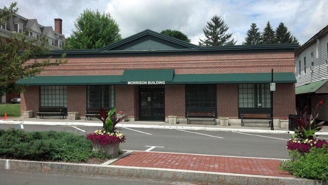
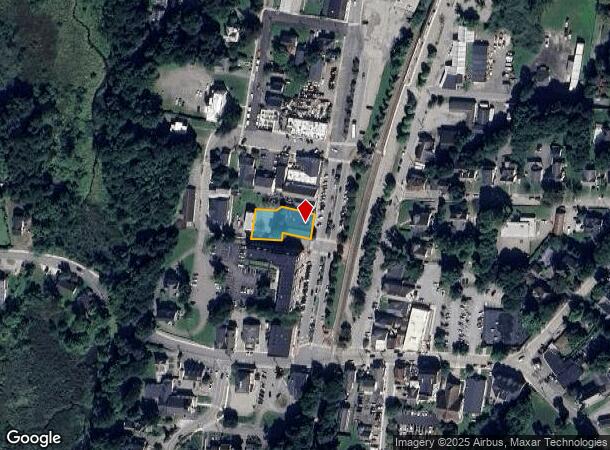
Property Record
36 Charles Colman Blvd, Pawling, NY 12564
NEARBY LISTINGS FOR SALE OR LEASE
Property Detail
36 Charles Colman Blvd
134001-7057-17-006027-0000
0.32 AC (C) 1935 0297 0764 0265
Commercialbuilding
Dutchess
X
New York
36027C0528E
6
2025
0.32 AC
2024
Fishkill
110005
Westchester/So Connecticut
7,708 SF
Dutchess County-Putnam County, NY
DEMOGRAPHICS near 36 Charles Colman Blvd
1 Mile
3 Mile
5 Mile
2024 Total Population
2,525
6,268
14,368
2029 Population
2,525
6,292
14,381
Pop Growth 2024-2029
0.00%
+ 0.38%
+ 0.09%
Average Age
45
45
44
2024 Total Households
1,095
2,461
5,253
HH Growth 2024-2029
0.00%
+ 0.37%
+ 0.04%
Median Household Inc
$93,172
$106,710
$105,803
Avg Household Size
2.30
2.50
2.60
2024 Avg HH Vehicles
2.00
2.00
2.00
Median Home Value
$351,184
$404,797
$411,657
Median Year Built
1960
1975
1973
Nearby Places
Map Layers
Map Styles
 Street
 Aerial
- Restaurants
- Banks
- Shops
- Fitness
- Groceries
PUBLIC TRANSPORTATION
TRANSIT/SUBWAY
Pawling Station (Harlem Line - Metro-North Commuter Railroad Company (Metro-North))
DRIVE
WALK
Distance
Pawling Station (Harlem Line - Metro-North Commuter Railroad Company (Metro-North))
2 min
4 min
0.2 mi
COMMUTER RAIL
Pawling Station (Harlem Line - Metro-North Commuter Railroad Company (Metro-North))
DRIVE
WALK
Distance
Pawling Station (Harlem Line - Metro-North Commuter Railroad Company (Metro-North))
2 min
3 min
0.2 mi
DRIVE
WALK
Distance
5 min
2.5 mi
AIRPORT
New York Stewart International
DRIVE
WALK
Distance
New York Stewart International
56 min
36.4 mi
Westchester County
DRIVE
WALK
Distance
Westchester County
52 min
38.3 mi
Freight Ports
Port of New Haven
DRIVE
WALK
Distance
Port of New Haven
82 min
52.9 mi
Nearby Properties
Address
Land Use
TOTAL SIZE
Lot Size
Zoning
Address
Land Use
TOTAL SIZE
Lot Size
Zoning
100.90 AC
R1
Address
Land Use
TOTAL SIZE
Lot Size
Zoning
121,767 SF
56 AC
R-2
Address
Land Use
TOTAL SIZE
Lot Size
Zoning
79,989 SF
8.40 AC
R1
Address
Land Use
TOTAL SIZE
Lot Size
Zoning
6.43 AC
R2
Address
Land Use
TOTAL SIZE
Lot Size
Zoning
292.50 AC
R-3
Address
Land Use
TOTAL SIZE
Lot Size
Zoning
5.54 AC
Address
Land Use
TOTAL SIZE
Lot Size
Zoning
4.47 AC
Address
Land Use
TOTAL SIZE
Lot Size
Zoning
816.62 AC
R-4
Address
Land Use
TOTAL SIZE
Lot Size
Zoning
21.57 AC
I-1
Address
Land Use
TOTAL SIZE
Lot Size
Zoning
3,232 SF
10.90 AC
CD-R5
Address
Land Use
TOTAL SIZE
Lot Size
Zoning
5.78 AC
I-1
Address
Land Use
TOTAL SIZE
Lot Size
Zoning
12.80 AC
VRD
Address
Land Use
TOTAL SIZE
Lot Size
Zoning
59,150 SF
1.20 AC
B1
Address
Land Use
TOTAL SIZE
Lot Size
Zoning
48,510 SF
15.84 AC
R-3
Address
Land Use
TOTAL SIZE
Lot Size
Zoning
13,655 SF
10.81 AC
VRD
Address
Land Use
TOTAL SIZE
Lot Size
Zoning
5,008 SF
310.43 AC
CD-R5
Address
Land Use
TOTAL SIZE
Lot Size
Zoning
39,107 SF
3.60 AC
R-1
Address
Land Use
TOTAL SIZE
Lot Size
Zoning
961.50 AC
R-4
Address
Land Use
TOTAL SIZE
Lot Size
Zoning
7,069 SF
160.78 AC
R-2
Address
Land Use
TOTAL SIZE
Lot Size
Zoning
41,000 SF
2.70 AC
HB
Address
Land Use
TOTAL SIZE
Lot Size
Zoning
17,000 SF
0.14 AC
B1
Address
Land Use
TOTAL SIZE
Lot Size
Zoning
33,600 SF
4.05 AC
HB
Address
Land Use
TOTAL SIZE
Lot Size
Zoning
32,400 SF
10.15 AC
HB
Address
Land Use
TOTAL SIZE
Lot Size
Zoning
8,944 SF
0.23 AC
B1
Address
Land Use
TOTAL SIZE
Lot Size
Zoning
5,069 SF
35.62 AC
C1
Address
Land Use
TOTAL SIZE
Lot Size
Zoning
4,050 SF
0.89 AC
C1
Address
Land Use
TOTAL SIZE
Lot Size
Zoning
11,152 SF
0.20 AC
B1
Address
Land Use
TOTAL SIZE
Lot Size
Zoning
8,448 SF
34.26 AC
CD-R5
Address
Land Use
TOTAL SIZE
Lot Size
Zoning
27,650 SF
2.22 AC
I-1
Address
Land Use
TOTAL SIZE
Lot Size
Zoning
2,718 SF
19.72 AC
R-3
The World's #1 Commercial Real Estate Marketplace
Connect with us
© 2025 CoStar Group
The information above has been obtained from sources believed reliable. While we do not doubt its accuracy we have not verified it and make no guarantee, warranty or representation about it. It is your responsibility to independently confirm its accuracy and completeness. Any projections, opinions, assumptions, or estimates used are for example only and do not represent the current or future performance of the property. The value of this transaction to you depends on tax and other factors which should be evaluated by your tax, financial, and legal advisors. You and your advisors should conduct a careful, independent investigation of the property to determine to your satisfaction the suitability of the property for your needs.