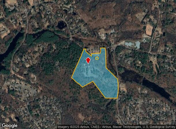
Property Record
36 Essex St, Wenham, MA 01984
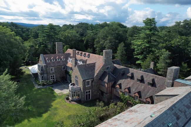

This Property Is For Sale
NEARBY LISTINGS FOR SALE OR LEASE
Property Detail
36 Essex St
WENH-000040-000000-000003
Essex
Publicschool
Massachusetts
A
3
25009C0426G
43.68 AC
2016
Essex/Gloucester
2025
Boston
216100
Boston-Cambridge-Newton, MA-NH
DEMOGRAPHICS near 36 Essex St
1 Mile
3 Mile
5 Mile
2024 Total Population
2,899
33,046
79,730
2029 Population
2,887
32,973
79,474
Pop Growth 2024-2029
(0.41%)
(0.22%)
(0.32%)
Average Age
39
41
41
2024 Total Households
866
11,438
30,801
HH Growth 2024-2029
(0.46%)
(0.26%)
(0.42%)
Median Household Inc
$150,708
$113,058
$104,805
Avg Household Size
2.80
2.50
2.40
2024 Avg HH Vehicles
2.00
2.00
2.00
Median Home Value
$679,842
$678,745
$646,548
Median Year Built
1974
1959
1957
Nearby Places
Map Layers
Map Styles
 Street
 Aerial
- Restaurants
- Banks
- Shops
- Fitness
- Groceries
PUBLIC TRANSPORTATION
COMMUTER RAIL
Hamilton/Wenham (Newburyport/Rockport Line - Massachusetts Bay Transportation Authority Commuter Rail (Purple Line))
DRIVE
WALK
Distance
Hamilton/Wenham (Newburyport/Rockport Line - Massachusetts Bay Transportation Authority Commuter Rail (Purple Line))
7 min
2.7 mi
North Beverly (Newburyport/Rockport Line - Massachusetts Bay Transportation Authority Commuter Rail (Purple Line))
DRIVE
WALK
Distance
North Beverly (Newburyport/Rockport Line - Massachusetts Bay Transportation Authority Commuter Rail (Purple Line))
8 min
3.6 mi
AIRPORT
General Edward Lawrence Logan International
DRIVE
WALK
Distance
General Edward Lawrence Logan International
39 min
21.0 mi
Freight Ports
Port of Boston
DRIVE
WALK
Distance
Port of Boston
45 min
28.3 mi
Nearby Properties
Address
Land Use
TOTAL SIZE
Lot Size
Zoning
Address
Land Use
TOTAL SIZE
Lot Size
Zoning
496,607 SF
71.29 AC
R45
Address
Land Use
TOTAL SIZE
Lot Size
Zoning
267,051 SF
41.08 AC
R10
Address
Land Use
TOTAL SIZE
Lot Size
Zoning
228,295 SF
12.50 AC
RMD
Address
Land Use
TOTAL SIZE
Lot Size
Zoning
231,509 SF
17.71 AC
R10
Address
Land Use
TOTAL SIZE
Lot Size
Zoning
64,451 SF
102.50 AC
R1A
Address
Land Use
TOTAL SIZE
Lot Size
Zoning
212,956 SF
44.90 AC
R1B
Address
Land Use
TOTAL SIZE
Lot Size
Zoning
207,237 SF
16.73 AC
RMD
Address
Land Use
TOTAL SIZE
Lot Size
Zoning
138,311 SF
56.04 AC
R45
Address
Land Use
TOTAL SIZE
Lot Size
Zoning
195,527 SF
16.60 AC
CG
Address
Land Use
TOTAL SIZE
Lot Size
Zoning
170,652 SF
23.73 AC
HD
Address
Land Use
TOTAL SIZE
Lot Size
Zoning
10,464 SF
237.02 AC
Address
Land Use
TOTAL SIZE
Lot Size
Zoning
108,259 SF
17.30 AC
R45
Address
Land Use
TOTAL SIZE
Lot Size
Zoning
123,171 SF
9.09 AC
R10
Address
Land Use
TOTAL SIZE
Lot Size
Zoning
64,845 SF
6.50 AC
RMD
Address
Land Use
TOTAL SIZE
Lot Size
Zoning
75,348 SF
1.35 AC
RMD
Address
Land Use
TOTAL SIZE
Lot Size
Zoning
207,095 SF
IR
Address
Land Use
TOTAL SIZE
Lot Size
Zoning
150,183 SF
38.84 AC
IR
Address
Land Use
TOTAL SIZE
Lot Size
Zoning
44,966 SF
86.67 AC
R45
Address
Land Use
TOTAL SIZE
Lot Size
Zoning
122,105 SF
12.96 AC
R10
Address
Land Use
TOTAL SIZE
Lot Size
Zoning
328.40 AC
R1A
Address
Land Use
TOTAL SIZE
Lot Size
Zoning
79,964 SF
7.78 AC
R15
Address
Land Use
TOTAL SIZE
Lot Size
Zoning
50,742 SF
6.68 AC
RMD
Address
Land Use
TOTAL SIZE
Lot Size
Zoning
68,740 SF
6.50 AC
IR
Address
Land Use
TOTAL SIZE
Lot Size
Zoning
140,215 SF
4.89 AC
RMD
Address
Land Use
TOTAL SIZE
Lot Size
Zoning
156,675 SF
IR
Address
Land Use
TOTAL SIZE
Lot Size
Zoning
57,157 SF
7.80 AC
Address
Land Use
TOTAL SIZE
Lot Size
Zoning
97,396 SF
IR
Address
Land Use
TOTAL SIZE
Lot Size
Zoning
60,343 SF
4.08 AC
HD
Address
Land Use
TOTAL SIZE
Lot Size
Zoning
93,605 SF
17.51 AC
R90
Address
Land Use
TOTAL SIZE
Lot Size
Zoning
2,705 SF
24.60 AC
The World's #1 Commercial Real Estate Marketplace
Connect with us
© 2026 CoStar Group
The information above has been obtained from sources believed reliable. While we do not doubt its accuracy we have not verified it and make no guarantee, warranty or representation about it. It is your responsibility to independently confirm its accuracy and completeness. Any projections, opinions, assumptions, or estimates used are for example only and do not represent the current or future performance of the property. The value of this transaction to you depends on tax and other factors which should be evaluated by your tax, financial, and legal advisors. You and your advisors should conduct a careful, independent investigation of the property to determine to your satisfaction the suitability of the property for your needs.