Property Record
3 Knotta Rd, Stonington, ME 04681
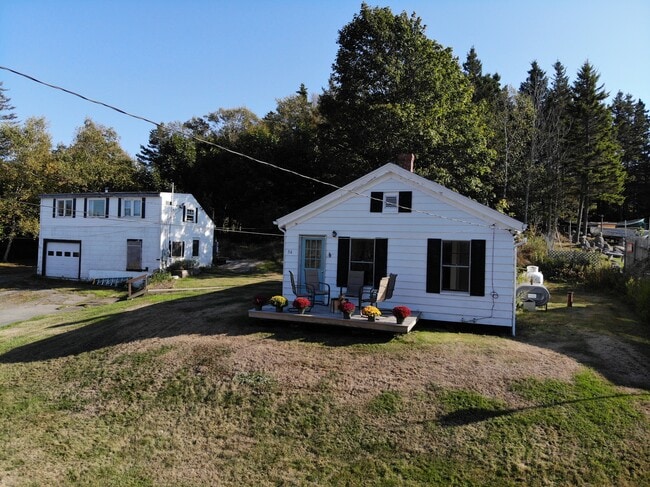


This Property Is For Sale
NEARBY LISTINGS FOR SALE OR LEASE
-
-
View all Stonington listings for sale on LoopNet.com
Property Detail
3 Knotta Rd
Other Market Areas
Hancock
STGT-000004B-000000-000031
Maine
Sfr
0.48 AC
X
Maine North & Bangor
23009C1368D
DEMOGRAPHICS near 3 Knotta Rd
1 Mile
3 Mile
5 Mile
2024 Total Population
351
1,121
2,114
2029 Population
354
1,132
2,147
Pop Growth 2024-2029
+ 0.85%
+ 0.98%
+ 1.56%
Average Age
49
48
48
2024 Total Households
173
536
970
HH Growth 2024-2029
+ 1.16%
+ 1.12%
+ 1.75%
Median Household Inc
$59,999
$60,114
$60,482
Avg Household Size
2.00
2.10
2.10
2024 Avg HH Vehicles
2.00
2.00
2.00
Median Home Value
$408,333
$320,689
$266,863
Median Year Built
1974
1974
1975
Nearby Places
Map Layers
Map Styles
 Street
 Aerial
- Restaurants
- Banks
- Shops
- Fitness
- Groceries
Nearby Properties
Address
Land Use
TOTAL SIZE
Lot Size
Zoning
Address
Land Use
TOTAL SIZE
Lot Size
Zoning
Address
Land Use
TOTAL SIZE
Lot Size
Zoning
2.47 AC
Address
Land Use
TOTAL SIZE
Lot Size
Zoning
1,188 SF
11.90 AC
Address
Land Use
TOTAL SIZE
Lot Size
Zoning
4.30 AC
Address
Land Use
TOTAL SIZE
Lot Size
Zoning
0.30 AC
Address
Land Use
TOTAL SIZE
Lot Size
Zoning
0.93 AC
Address
Land Use
TOTAL SIZE
Lot Size
Zoning
0.40 AC
Address
Land Use
TOTAL SIZE
Lot Size
Zoning
60 AC
Address
Land Use
TOTAL SIZE
Lot Size
Zoning
0.20 AC
Address
Land Use
TOTAL SIZE
Lot Size
Zoning
Address
Land Use
TOTAL SIZE
Lot Size
Zoning
44.20 AC
Address
Land Use
TOTAL SIZE
Lot Size
Zoning
0.27 AC
Address
Land Use
TOTAL SIZE
Lot Size
Zoning
0.50 AC
Address
Land Use
TOTAL SIZE
Lot Size
Zoning
0.20 AC
Address
Land Use
TOTAL SIZE
Lot Size
Zoning
0.20 AC
Address
Land Use
TOTAL SIZE
Lot Size
Zoning
33.20 AC
Address
Land Use
TOTAL SIZE
Lot Size
Zoning
0.29 AC
Address
Land Use
TOTAL SIZE
Lot Size
Zoning
Address
Land Use
TOTAL SIZE
Lot Size
Zoning
Address
Land Use
TOTAL SIZE
Lot Size
Zoning
5.60 AC
Address
Land Use
TOTAL SIZE
Lot Size
Zoning
Address
Land Use
TOTAL SIZE
Lot Size
Zoning
0.50 AC
Address
Land Use
TOTAL SIZE
Lot Size
Zoning
14.20 AC
Address
Land Use
TOTAL SIZE
Lot Size
Zoning
Address
Land Use
TOTAL SIZE
Lot Size
Zoning
0.07 AC
Address
Land Use
TOTAL SIZE
Lot Size
Zoning
0.07 AC
Address
Land Use
TOTAL SIZE
Lot Size
Zoning
0.09 AC
Address
Land Use
TOTAL SIZE
Lot Size
Zoning
0.21 AC
Address
Land Use
TOTAL SIZE
Lot Size
Zoning
0.39 AC
Address
Land Use
TOTAL SIZE
Lot Size
Zoning
6.90 AC
The World's #1 Commercial Real Estate Marketplace
Connect with us
© 2025 CoStar Group
The information above has been obtained from sources believed reliable. While we do not doubt its accuracy we have not verified it and make no guarantee, warranty or representation about it. It is your responsibility to independently confirm its accuracy and completeness. Any projections, opinions, assumptions, or estimates used are for example only and do not represent the current or future performance of the property. The value of this transaction to you depends on tax and other factors which should be evaluated by your tax, financial, and legal advisors. You and your advisors should conduct a careful, independent investigation of the property to determine to your satisfaction the suitability of the property for your needs.