Property Record
36 Highway Byp, Rosenberg, TX 77471
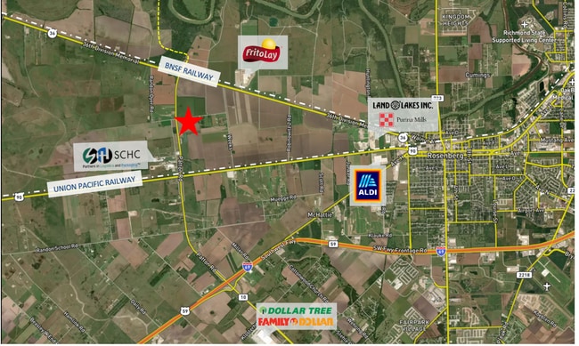

Property Detail
36 Highway Byp
Houston-Pasadena-The Woodlands, TX
0146 BROOKS AND BURL, ACRES 40.541, (NOT IN CITY OF ROSENBERG), PART OF A 64.666 ACRE TRACT
0146-00-000-0044-901
FORT BEND
Farms
Texas
B and X Area of moderate flood hazard, usually the area between the limits of the 100-year and 500-year floods.
4
2024
24.13 AC
2025
Southwest Outlier
675300
Houston
NEARBY LISTINGS FOR SALE OR LEASE
DEMOGRAPHICS near 36 Highway Byp
1 mile
3 mile
5 mile
2025 Total Population
60
1,118
12,013
2030 Population
70
1,290
13,730
Pop Growth 2025-2030
+ 16.67%
+ 15.38%
+ 14.29%
Average Age
40
37
38
2025 Total Households
21
353
3,864
HH Growth 2025-2030
+ 14.29%
+ 15.58%
+ 14.70%
Median Household Inc
$55,000
$74,021
$67,910
Avg Household Size
3.00
3.20
3.10
2025 Avg HH Vehicles
2.00
2.00
2.00
Median Home Value
$399,999
$321,428
$208,118
Median Year Built
1996
1991
1990
Nearby Places
Map Layers
Map Styles
 Street
 Aerial
Transit
 Traffic
 Biking
Places
Listings with unknown addresses are not visible on the map
- Restaurants
- Banks
- Shops
- Fitness
- Groceries
SALE & LEASE HISTORY
LISTING DATE
SALE/LEASE

Oct 05, 2023
For Sale
Nov 04, 2020
For Sale
Nearby Properties
Address
Land Use
TOTAL SIZE
Lot Size
Zoning
Address
Land Use
TOTAL SIZE
Lot Size
Zoning
37.08 AC
Address
Land Use
TOTAL SIZE
Lot Size
Zoning
19.57 AC
OY
Address
Land Use
TOTAL SIZE
Lot Size
Zoning
9.51 AC
Address
Land Use
TOTAL SIZE
Lot Size
Zoning
11,800 SF
9.26 AC
S
Address
Land Use
TOTAL SIZE
Lot Size
Zoning
105,350 SF
11.50 AC
R
Address
Land Use
TOTAL SIZE
Lot Size
Zoning
220,453 SF
142.24 AC
SQ
Address
Land Use
TOTAL SIZE
Lot Size
Zoning
51,250 SF
10.01 AC
S
Address
Land Use
TOTAL SIZE
Lot Size
Zoning
10,737 SF
8.26 AC
Address
Land Use
TOTAL SIZE
Lot Size
Zoning
67.93 AC
Address
Land Use
TOTAL SIZE
Lot Size
Zoning
139,047 SF
49.85 AC
Address
Land Use
TOTAL SIZE
Lot Size
Zoning
40,876 SF
7.69 AC
S
Address
Land Use
TOTAL SIZE
Lot Size
Zoning
20,785 SF
10 AC
QS
Address
Land Use
TOTAL SIZE
Lot Size
Zoning
15,396 SF
3.27 AC
Address
Land Use
TOTAL SIZE
Lot Size
Zoning
68.41 AC
Y
Address
Land Use
TOTAL SIZE
Lot Size
Zoning
1,260 SF
36.99 AC
YOQT
Address
Land Use
TOTAL SIZE
Lot Size
Zoning
13,280 SF
17.10 AC
YZ
Address
Land Use
TOTAL SIZE
Lot Size
Zoning
177,887 SF
37 AC
YQM
Address
Land Use
TOTAL SIZE
Lot Size
Zoning
4,104 SF
3.77 AC
M
Address
Land Use
TOTAL SIZE
Lot Size
Zoning
9.95 AC
S
Address
Land Use
TOTAL SIZE
Lot Size
Zoning
78 AC
SO
Address
Land Use
TOTAL SIZE
Lot Size
Zoning
11.50 AC
Address
Land Use
TOTAL SIZE
Lot Size
Zoning
65.97 AC
QY
Address
Land Use
TOTAL SIZE
Lot Size
Zoning
17,532 SF
5.98 AC
SQ
Address
Land Use
TOTAL SIZE
Lot Size
Zoning
1,100 SF
6.21 AC
M
Address
Land Use
TOTAL SIZE
Lot Size
Zoning
1,112 SF
124.60 AC
OYNQ
Address
Land Use
TOTAL SIZE
Lot Size
Zoning
9.85 AC
S
Address
Land Use
TOTAL SIZE
Lot Size
Zoning
10.35 AC
Address
Land Use
TOTAL SIZE
Lot Size
Zoning
15.79 AC
Address
Land Use
TOTAL SIZE
Lot Size
Zoning
3,040 SF
22.29 AC
SY
Address
Land Use
TOTAL SIZE
Lot Size
Zoning
29 AC
S
The World's #1 Commercial Real Estate Marketplace
Connect with us
© 2026 CoStar Group
The information above has been obtained from sources believed reliable. While we do not doubt its accuracy we have not verified it and make no guarantee, warranty or representation about it. It is your responsibility to independently confirm its accuracy and completeness. Any projections, opinions, assumptions, or estimates used are for example only and do not represent the current or future performance of the property. The value of this transaction to you depends on tax and other factors which should be evaluated by your tax, financial, and legal advisors. You and your advisors should conduct a careful, independent investigation of the property to determine to your satisfaction the suitability of the property for your needs.