Property Record
36 Indian Rock Rd, Windham, NH 03087
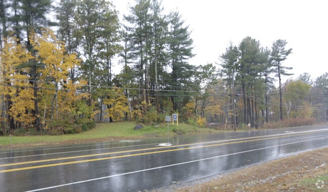

This Property Is For Sale
Current Lease Availabilities
NEARBY LISTINGS FOR SALE OR LEASE
Property Detail
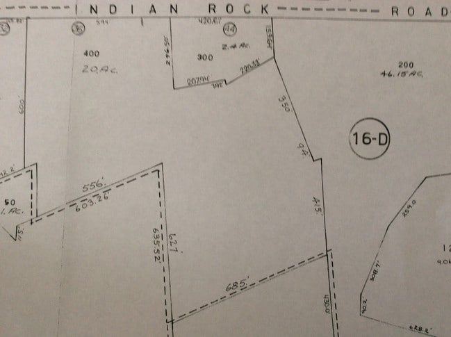
36 Indian Rock Rd
WNDM-000016-D000000-000400
Rockingham
Privatepreserveopenspacevacantlandforestlandconservation
New Hampshire
X
400
33015C0541E
20 AC
2024
Rockingham
2024
Boston
106101
Boston-Cambridge-Newton, MA-NH
DEMOGRAPHICS near 36 Indian Rock Rd
1 Mile
3 Mile
5 Mile
2024 Total Population
1,913
17,811
63,461
2029 Population
2,001
18,496
65,798
Pop Growth 2024-2029
+ 4.60%
+ 3.85%
+ 3.68%
Average Age
44
42
43
2024 Total Households
680
6,035
23,822
HH Growth 2024-2029
+ 4.71%
+ 3.83%
+ 3.73%
Median Household Inc
$140,499
$148,961
$117,643
Avg Household Size
2.70
2.90
2.60
2024 Avg HH Vehicles
3.00
2.00
2.00
Median Home Value
$732,009
$584,813
$433,693
Median Year Built
1985
1986
1983
Nearby Places
Map Layers
Map Styles
 Street
 Aerial
- Restaurants
- Banks
- Shops
- Fitness
- Groceries
PUBLIC TRANSPORTATION
AIRPORT
Manchester Boston Regional
DRIVE
WALK
Distance
Manchester Boston Regional
30 min
17.5 mi
Freight Ports
Port of Boston
DRIVE
WALK
Distance
Port of Boston
56 min
39.6 mi
Nearby Properties
Address
Land Use
TOTAL SIZE
Lot Size
Zoning
Address
Land Use
TOTAL SIZE
Lot Size
Zoning
75.16 AC
CIB
Address
Land Use
TOTAL SIZE
Lot Size
Zoning
195,778 SF
101.88 AC
RD
Address
Land Use
TOTAL SIZE
Lot Size
Zoning
72.18 AC
CIB
Address
Land Use
TOTAL SIZE
Lot Size
Zoning
7.99 AC
CIB
Address
Land Use
TOTAL SIZE
Lot Size
Zoning
58,339 SF
47.49 AC
RD
Address
Land Use
TOTAL SIZE
Lot Size
Zoning
215,338 SF
66.52 AC
CIB
Address
Land Use
TOTAL SIZE
Lot Size
Zoning
13,158 SF
52.40 AC
VCD
Address
Land Use
TOTAL SIZE
Lot Size
Zoning
113,388 SF
16.28 AC
CIB
Address
Land Use
TOTAL SIZE
Lot Size
Zoning
71,854 SF
26 AC
RD
Address
Land Use
TOTAL SIZE
Lot Size
Zoning
155,040 SF
16.36 AC
IND
Address
Land Use
TOTAL SIZE
Lot Size
Zoning
21,433 SF
7.54 AC
LID
Address
Land Use
TOTAL SIZE
Lot Size
Zoning
63,628 SF
34.21 AC
CDA
Address
Land Use
TOTAL SIZE
Lot Size
Zoning
59,565 SF
41.20 AC
RD
Address
Land Use
TOTAL SIZE
Lot Size
Zoning
19,920 SF
15 AC
PBT
Address
Land Use
TOTAL SIZE
Lot Size
Zoning
72,868 SF
6.58 AC
IND
Address
Land Use
TOTAL SIZE
Lot Size
Zoning
64,896 SF
11.68 AC
IND
Address
Land Use
TOTAL SIZE
Lot Size
Zoning
59,626 SF
7.40 AC
VCD
Address
Land Use
TOTAL SIZE
Lot Size
Zoning
99,833 SF
15.26 AC
IND
Address
Land Use
TOTAL SIZE
Lot Size
Zoning
52,648 SF
7.68 AC
CIB
Address
Land Use
TOTAL SIZE
Lot Size
Zoning
49,340 SF
9.22 AC
IND
Address
Land Use
TOTAL SIZE
Lot Size
Zoning
61,252 SF
4.52 AC
IND
Address
Land Use
TOTAL SIZE
Lot Size
Zoning
7.21 AC
IND5
Address
Land Use
TOTAL SIZE
Lot Size
Zoning
3,602 SF
7.45 AC
RD
Address
Land Use
TOTAL SIZE
Lot Size
Zoning
13,673 SF
11.76 AC
CDA
Address
Land Use
TOTAL SIZE
Lot Size
Zoning
11,412 SF
4.21 AC
CDA
Address
Land Use
TOTAL SIZE
Lot Size
Zoning
39,454 SF
3.36 AC
CIB
Address
Land Use
TOTAL SIZE
Lot Size
Zoning
5.81 AC
IND
Address
Land Use
TOTAL SIZE
Lot Size
Zoning
40,000 SF
7.53 AC
CDA
Address
Land Use
TOTAL SIZE
Lot Size
Zoning
23,964 SF
12.47 AC
MZ
Address
Land Use
TOTAL SIZE
Lot Size
Zoning
41,840 SF
2.59 AC
IND
The World's #1 Commercial Real Estate Marketplace
Connect with us
© 2025 CoStar Group
The information above has been obtained from sources believed reliable. While we do not doubt its accuracy we have not verified it and make no guarantee, warranty or representation about it. It is your responsibility to independently confirm its accuracy and completeness. Any projections, opinions, assumptions, or estimates used are for example only and do not represent the current or future performance of the property. The value of this transaction to you depends on tax and other factors which should be evaluated by your tax, financial, and legal advisors. You and your advisors should conduct a careful, independent investigation of the property to determine to your satisfaction the suitability of the property for your needs.