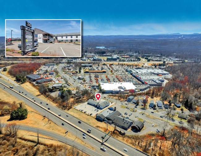
Property Record
36 Main St, East Hartford, CT 06118

NEARBY LISTINGS FOR SALE OR LEASE
Property Detail
36 Main St
EHAR-000029-000000-000046
Hartford
Commercialnec
Connecticut
AE
46
09003C0526F
1.12 AC
2025
East Hartford
2025
Hartford
510800
Hartford-West Hartford-East Hartford, CT
DEMOGRAPHICS near 36 Main St
1 Mile
3 Mile
5 Mile
2024 Total Population
9,413
51,281
202,236
2029 Population
9,356
50,986
201,641
Pop Growth 2024-2029
(0.61%)
(0.58%)
(0.29%)
Average Age
41
41
39
2024 Total Households
4,002
21,181
81,412
HH Growth 2024-2029
(0.60%)
(0.62%)
(0.18%)
Median Household Inc
$75,530
$77,835
$62,911
Avg Household Size
2.30
2.40
2.40
2024 Avg HH Vehicles
2.00
2.00
1.00
Median Home Value
$168,354
$234,809
$242,958
Median Year Built
1964
1962
1960
Nearby Places
Map Layers
Map Styles
 Street
 Aerial
- Restaurants
- Banks
- Shops
- Fitness
- Groceries
PUBLIC TRANSPORTATION
COMMUTER RAIL
DRIVE
WALK
Distance
10 min
5.1 mi
DRIVE
WALK
Distance
10 min
5.1 mi
AIRPORT
Bradley International
DRIVE
WALK
Distance
Bradley International
39 min
21.1 mi
Tweed/New Haven
DRIVE
WALK
Distance
Tweed/New Haven
54 min
39.2 mi
SALE & LEASE HISTORY
LISTING DATE
SALE/LEASE

Sep 24, 2016
For Sale
Jan 09, 2018
For Lease
Apr 28, 2017
For Lease
Apr 18, 2023
For Sale
Apr 10, 2019
For Lease
Nearby Properties
Address
Land Use
TOTAL SIZE
Lot Size
Zoning
Address
Land Use
TOTAL SIZE
Lot Size
Zoning
149.23 AC
DDD1
Address
Land Use
TOTAL SIZE
Lot Size
Zoning
112.42 AC
DDD1
Address
Land Use
TOTAL SIZE
Lot Size
Zoning
69.42 AC
CT R
Address
Land Use
TOTAL SIZE
Lot Size
Zoning
2,500 SF
74.98 AC
I-2
Address
Land Use
TOTAL SIZE
Lot Size
Zoning
9.92 AC
DDD1
Address
Land Use
TOTAL SIZE
Lot Size
Zoning
49,219 SF
31.72 AC
Address
Land Use
TOTAL SIZE
Lot Size
Zoning
235,476 SF
198.32 AC
CT R
Address
Land Use
TOTAL SIZE
Lot Size
Zoning
109,276 SF
11 AC
DDD1
Address
Land Use
TOTAL SIZE
Lot Size
Zoning
36.69 AC
R-5
Address
Land Use
TOTAL SIZE
Lot Size
Zoning
55.64 AC
Address
Land Use
TOTAL SIZE
Lot Size
Zoning
348,943 SF
51.21 AC
R-2
Address
Land Use
TOTAL SIZE
Lot Size
Zoning
160,936 SF
2.40 AC
CX-1
Address
Land Use
TOTAL SIZE
Lot Size
Zoning
81,313 SF
4.44 AC
R-3
Address
Land Use
TOTAL SIZE
Lot Size
Zoning
188,454 SF
178.60 AC
A
Address
Land Use
TOTAL SIZE
Lot Size
Zoning
7.07 AC
PBD
Address
Land Use
TOTAL SIZE
Lot Size
Zoning
116,979 SF
17 AC
B
Address
Land Use
TOTAL SIZE
Lot Size
Zoning
18.26 AC
R-5
Address
Land Use
TOTAL SIZE
Lot Size
Zoning
129,065 SF
4.63 AC
MX-2
Address
Land Use
TOTAL SIZE
Lot Size
Zoning
Address
Land Use
TOTAL SIZE
Lot Size
Zoning
126,934 SF
1.51 AC
B-4
Address
Land Use
TOTAL SIZE
Lot Size
Zoning
11.95 AC
PAD
Address
Land Use
TOTAL SIZE
Lot Size
Zoning
15.12 AC
PAD
Address
Land Use
TOTAL SIZE
Lot Size
Zoning
Address
Land Use
TOTAL SIZE
Lot Size
Zoning
8.14 AC
Address
Land Use
TOTAL SIZE
Lot Size
Zoning
181,421 SF
18.36 AC
DDD1
Address
Land Use
TOTAL SIZE
Lot Size
Zoning
20.36 AC
B-1
Address
Land Use
TOTAL SIZE
Lot Size
Zoning
33.19 AC
ID-1
Address
Land Use
TOTAL SIZE
Lot Size
Zoning
158,692 SF
2.89 AC
PAD
Address
Land Use
TOTAL SIZE
Lot Size
Zoning
105,294 SF
2.49 AC
PAD
Address
Land Use
TOTAL SIZE
Lot Size
Zoning
7.90 AC
The World's #1 Commercial Real Estate Marketplace
Connect with us
© 2026 CoStar Group
The information above has been obtained from sources believed reliable. While we do not doubt its accuracy we have not verified it and make no guarantee, warranty or representation about it. It is your responsibility to independently confirm its accuracy and completeness. Any projections, opinions, assumptions, or estimates used are for example only and do not represent the current or future performance of the property. The value of this transaction to you depends on tax and other factors which should be evaluated by your tax, financial, and legal advisors. You and your advisors should conduct a careful, independent investigation of the property to determine to your satisfaction the suitability of the property for your needs.