Property Record
36 Mill Creek Ct, Charlottesville, VA 22902


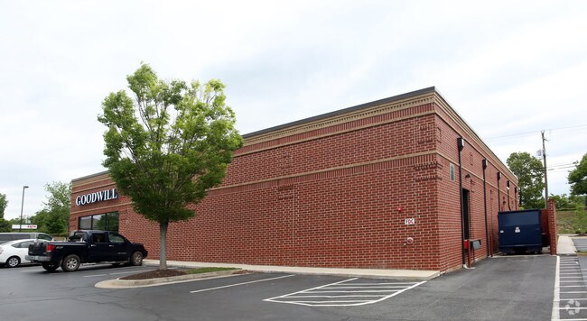
Property Detail
36 Mill Creek Ct
07700-00-00-047A0
ACREAGE PARCEL A
Storebuilding
ALBEMARLE
PLANNED DE
Virginia
B and X Area of moderate flood hazard, usually the area between the limits of the 100-year and 500-year floods.
0.73 AC
2025
Charlottesville
2026
Other Market Areas
011303
Charlottesville, VA
10,260 SF
NEARBY LISTINGS FOR SALE OR LEASE
DEMOGRAPHICS near 36 Mill Creek Ct
1 mile
3 mile
5 mile
2025 Total Population
5,059
54,387
86,758
2030 Population
5,209
54,403
87,363
Pop Growth 2025-2030
+ 2.97%
+ 0.03%
+ 0.70%
Average Age
40
34
37
2025 Total Households
2,133
20,933
35,129
HH Growth 2025-2030
+ 3.19%
(0.17%)
+ 0.77%
Median Household Inc
$102,570
$70,875
$76,475
Avg Household Size
2.20
2.20
2.20
2025 Avg HH Vehicles
2.00
2.00
2.00
Median Home Value
$420,552
$442,694
$473,433
Median Year Built
1995
1984
1984
Nearby Places
Map Layers
Map Styles
 Street
 Aerial
Layers
 Traffic
 Biking
Places
Listings with unknown addresses are not visible on the map
- Restaurants
- Banks
- Shops
- Fitness
- Groceries
PUBLIC TRANSPORTATION
COMMUTER RAIL
Drive
Walk
Distance
9 min
3.0 mi
AIRPORT
Charlottesville-Albemarle
Drive
Walk
Distance
Charlottesville-Albemarle
28 min
12.5 mi
Nearby Properties
Address
Land Use
TOTAL SIZE
Lot Size
Zoning
Address
Land Use
TOTAL SIZE
Lot Size
Zoning
872,960 SF
20.90 AC
CM
Address
Land Use
TOTAL SIZE
Lot Size
Zoning
5,672 SF
24.90 AC
RURAL AREA
Address
Land Use
TOTAL SIZE
Lot Size
Zoning
45 AC
RURAL AREA
Address
Land Use
TOTAL SIZE
Lot Size
Zoning
167,708 SF
1.05 AC
CM
Address
Land Use
TOTAL SIZE
Lot Size
Zoning
34.70 AC
RURAL AREA
Address
Land Use
TOTAL SIZE
Lot Size
Zoning
15 AC
RURAL AREA
Address
Land Use
TOTAL SIZE
Lot Size
Zoning
250 SF
44.20 AC
RURAL AREA
Address
Land Use
TOTAL SIZE
Lot Size
Zoning
165,360 SF
25.70 AC
RURAL AREA
Address
Land Use
TOTAL SIZE
Lot Size
Zoning
45,873 SF
30 AC
RURAL AREA
Address
Land Use
TOTAL SIZE
Lot Size
Zoning
101,778 SF
11.11 AC
CM
Address
Land Use
TOTAL SIZE
Lot Size
Zoning
10,270 SF
3.59 AC
RX-5
Address
Land Use
TOTAL SIZE
Lot Size
Zoning
99,841 SF
47.68 AC
PLANNED DE
Address
Land Use
TOTAL SIZE
Lot Size
Zoning
43,616 SF
2.24 AC
CX-8
Address
Land Use
TOTAL SIZE
Lot Size
Zoning
578,208 SF
2.06 AC
CX-8
Address
Land Use
TOTAL SIZE
Lot Size
Zoning
12,180 SF
26.20 AC
RURAL AREA
Address
Land Use
TOTAL SIZE
Lot Size
Zoning
983 SF
0.39 AC
CM
Address
Land Use
TOTAL SIZE
Lot Size
Zoning
250,632 SF
1.79 AC
CM
Address
Land Use
TOTAL SIZE
Lot Size
Zoning
14,000 SF
6.45 AC
CX-5
Address
Land Use
TOTAL SIZE
Lot Size
Zoning
67,354 SF
18.86 AC
CM
Address
Land Use
TOTAL SIZE
Lot Size
Zoning
30,896 SF
0.97 AC
DX
Address
Land Use
TOTAL SIZE
Lot Size
Zoning
240,936 SF
1.26 AC
NX-10
Address
Land Use
TOTAL SIZE
Lot Size
Zoning
131,500 SF
65.97 AC
R15 RESIDE
Address
Land Use
TOTAL SIZE
Lot Size
Zoning
14,025 SF
10.94 AC
RX-5
Address
Land Use
TOTAL SIZE
Lot Size
Zoning
43,120 SF
4.08 AC
CM
Address
Land Use
TOTAL SIZE
Lot Size
Zoning
218,660 SF
1.27 AC
CX-8
Address
Land Use
TOTAL SIZE
Lot Size
Zoning
1.38 AC
CX-3
Address
Land Use
TOTAL SIZE
Lot Size
Zoning
57,600 SF
8.25 AC
R1 RESIDEN
Address
Land Use
TOTAL SIZE
Lot Size
Zoning
222,253 SF
0.73 AC
NX-10
Address
Land Use
TOTAL SIZE
Lot Size
Zoning
110,969 SF
2.06 AC
CM
Address
Land Use
TOTAL SIZE
Lot Size
Zoning
5,136 SF
4.27 AC
RX-5
The World's #1 Commercial Real Estate Marketplace
Connect with us
© 2026 CoStar Group
The information above has been obtained from sources believed reliable. While we do not doubt its accuracy we have not verified it and make no guarantee, warranty or representation about it. It is your responsibility to independently confirm its accuracy and completeness. Any projections, opinions, assumptions, or estimates used are for example only and do not represent the current or future performance of the property. The value of this transaction to you depends on tax and other factors which should be evaluated by your tax, financial, and legal advisors. You and your advisors should conduct a careful, independent investigation of the property to determine to your satisfaction the suitability of the property for your needs.