Property Record
36 County Road 6245 Planterview Rd, Dayton, TX 77535
Current Lease Availabilities
NEARBY LISTINGS FOR SALE OR LEASE
-
-
View all Dayton listings for lease on LoopNet.com
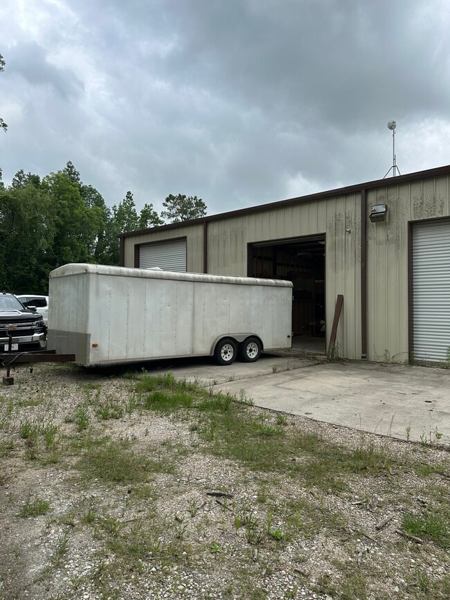
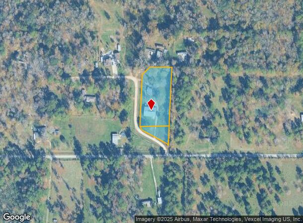
Property Detail
36 County Road 6245 Planterview Rd
Houston-Pasadena-The Woodlands, TX
Plantersview Estates
007070-000009-002
PLANTERSVIEW ESTATES, BLOCK 2, SEC 1, LOT 1-5, ACRES 2.116
Sfr
Liberty
X
Texas
48291C0400C
1-5
2024
2.12 AC
2025
Liberty County
000070
Houston
800 SF
DEMOGRAPHICS near 36 County Road 6245 Planterview Rd
1 Mile
3 Mile
5 Mile
2024 Total Population
121
1,497
10,663
2029 Population
162
1,663
11,738
Pop Growth 2024-2029
+ 33.88%
+ 11.09%
+ 10.08%
Average Age
41
38
38
2024 Total Households
42
494
3,438
HH Growth 2024-2029
+ 33.33%
+ 10.93%
+ 9.34%
Median Household Inc
$56,249
$80,190
$78,715
Avg Household Size
2.90
2.90
3.00
2024 Avg HH Vehicles
2.00
2.00
2.00
Median Home Value
$250,000
$286,363
$286,807
Median Year Built
2007
1992
1996
Nearby Places
Map Layers
Map Styles
 Street
 Aerial
- Restaurants
- Banks
- Shops
- Fitness
- Groceries
PUBLIC TRANSPORTATION
AIRPORT
George Bush Intcntl/Houston
DRIVE
WALK
Distance
George Bush Intcntl/Houston
49 min
27.9 mi
William P Hobby
DRIVE
WALK
Distance
William P Hobby
73 min
47.6 mi
Freight Ports
Port of Houston
DRIVE
WALK
Distance
Port of Houston
60 min
39.6 mi
Nearby Properties
Address
Land Use
TOTAL SIZE
Lot Size
Zoning
Address
Land Use
TOTAL SIZE
Lot Size
Zoning
321.21 AC
Address
Land Use
TOTAL SIZE
Lot Size
Zoning
1,049.13 AC
Address
Land Use
TOTAL SIZE
Lot Size
Zoning
298.07 AC
Address
Land Use
TOTAL SIZE
Lot Size
Zoning
5,808 SF
10.23 AC
Address
Land Use
TOTAL SIZE
Lot Size
Zoning
5,784 SF
10.25 AC
Address
Land Use
TOTAL SIZE
Lot Size
Zoning
184.01 AC
Address
Land Use
TOTAL SIZE
Lot Size
Zoning
6,616 SF
8.49 AC
Address
Land Use
TOTAL SIZE
Lot Size
Zoning
13,467 SF
10 AC
Address
Land Use
TOTAL SIZE
Lot Size
Zoning
4,222 SF
10.24 AC
Address
Land Use
TOTAL SIZE
Lot Size
Zoning
4,821 SF
10.23 AC
Address
Land Use
TOTAL SIZE
Lot Size
Zoning
8,767 SF
5 AC
Address
Land Use
TOTAL SIZE
Lot Size
Zoning
6,273 SF
9 AC
Address
Land Use
TOTAL SIZE
Lot Size
Zoning
952 SF
30.60 AC
Address
Land Use
TOTAL SIZE
Lot Size
Zoning
4,210 SF
10.25 AC
Address
Land Use
TOTAL SIZE
Lot Size
Zoning
3,431 SF
10.25 AC
Address
Land Use
TOTAL SIZE
Lot Size
Zoning
5,997 SF
1.05 AC
Address
Land Use
TOTAL SIZE
Lot Size
Zoning
6,003 SF
4.61 AC
Address
Land Use
TOTAL SIZE
Lot Size
Zoning
10,725 SF
6.45 AC
Address
Land Use
TOTAL SIZE
Lot Size
Zoning
4,165 SF
10.10 AC
Address
Land Use
TOTAL SIZE
Lot Size
Zoning
2,312 SF
8.31 AC
Address
Land Use
TOTAL SIZE
Lot Size
Zoning
449.41 AC
Address
Land Use
TOTAL SIZE
Lot Size
Zoning
7,758 SF
0.78 AC
Address
Land Use
TOTAL SIZE
Lot Size
Zoning
4,743 SF
10.22 AC
Address
Land Use
TOTAL SIZE
Lot Size
Zoning
9,800 SF
5 AC
Address
Land Use
TOTAL SIZE
Lot Size
Zoning
4,455 SF
2.89 AC
Address
Land Use
TOTAL SIZE
Lot Size
Zoning
4,693 SF
0.75 AC
Address
Land Use
TOTAL SIZE
Lot Size
Zoning
5,337 SF
1.59 AC
Address
Land Use
TOTAL SIZE
Lot Size
Zoning
5,085 SF
2.03 AC
Address
Land Use
TOTAL SIZE
Lot Size
Zoning
4,400 SF
2 AC
Address
Land Use
TOTAL SIZE
Lot Size
Zoning
4,803 SF
4 AC
The World's #1 Commercial Real Estate Marketplace
Connect with us
© 2026 CoStar Group
The information above has been obtained from sources believed reliable. While we do not doubt its accuracy we have not verified it and make no guarantee, warranty or representation about it. It is your responsibility to independently confirm its accuracy and completeness. Any projections, opinions, assumptions, or estimates used are for example only and do not represent the current or future performance of the property. The value of this transaction to you depends on tax and other factors which should be evaluated by your tax, financial, and legal advisors. You and your advisors should conduct a careful, independent investigation of the property to determine to your satisfaction the suitability of the property for your needs.