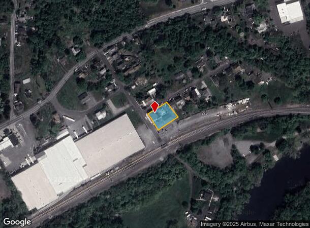
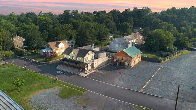
Property Record
36 Railroad St, Royersford, PA 19468
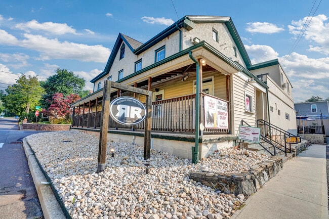
This Property Is For Sale
NEARBY LISTINGS FOR SALE OR LEASE
Property Detail
36 Railroad St
Philadelphia-Camden-Wilmington, PA-NJ-DE-MD
Linfield Station Noble Prop
37-00-03559-004
ASSESSOR BLOCK-UNIT NUMBER 38-13
Bartavern
Montgomery
X
Pennsylvania
42029C0020G
13
2024
0.47 AC
2025
West Montgomery County
208603
Philadelphia
11,252 SF
DEMOGRAPHICS near 36 Railroad St
1 Mile
3 Mile
5 Mile
2024 Total Population
2,736
38,236
96,275
2029 Population
2,764
39,311
98,675
Pop Growth 2024-2029
+ 1.02%
+ 2.81%
+ 2.49%
Average Age
44
42
41
2024 Total Households
1,041
15,345
36,534
HH Growth 2024-2029
+ 0.96%
+ 2.83%
+ 2.56%
Median Household Inc
$104,929
$94,550
$100,987
Avg Household Size
2.60
2.40
2.60
2024 Avg HH Vehicles
2.00
2.00
2.00
Median Home Value
$477,511
$377,388
$386,217
Median Year Built
1992
1989
1980
Nearby Places
- Restaurants
- Banks
- Shops
- Fitness
- Groceries
PUBLIC TRANSPORTATION
AIRPORT
Lehigh Valley International
DRIVE
WALK
Distance
Lehigh Valley International
70 min
40.1 mi
Philadelphia International
DRIVE
WALK
Distance
Philadelphia International
63 min
41.8 mi
Freight Ports
South Jersey Port
DRIVE
WALK
Distance
South Jersey Port
57 min
37.9 mi
Nearby Properties
Address
Land Use
TOTAL SIZE
Lot Size
Zoning
Address
Land Use
TOTAL SIZE
Lot Size
Zoning
605,161 SF
78.08 AC
LLI
Address
Land Use
TOTAL SIZE
Lot Size
Zoning
208,637 SF
13.37 AC
AG
Address
Land Use
TOTAL SIZE
Lot Size
Zoning
416,228 SF
18.24 AC
R3
Address
Land Use
TOTAL SIZE
Lot Size
Zoning
368,083 SF
126.15 AC
R2
Address
Land Use
TOTAL SIZE
Lot Size
Zoning
1,298,806 SF
305.46 AC
HI
Address
Land Use
TOTAL SIZE
Lot Size
Zoning
268,366 SF
32.55 AC
R4
Address
Land Use
TOTAL SIZE
Lot Size
Zoning
271,556 SF
38.87 AC
R4
Address
Land Use
TOTAL SIZE
Lot Size
Zoning
316,623 SF
15.26 AC
R4
Address
Land Use
TOTAL SIZE
Lot Size
Zoning
407,301 SF
8.04 AC
ARU
Address
Land Use
TOTAL SIZE
Lot Size
Zoning
233,630 SF
15 AC
R4
Address
Land Use
TOTAL SIZE
Lot Size
Zoning
185,077 SF
6.10 AC
MS
Address
Land Use
TOTAL SIZE
Lot Size
Zoning
125,788 SF
24.83 AC
R1
Address
Land Use
TOTAL SIZE
Lot Size
Zoning
97,188 SF
13.13 AC
OLI
Address
Land Use
TOTAL SIZE
Lot Size
Zoning
134,334 SF
21.95 AC
RB
Address
Land Use
TOTAL SIZE
Lot Size
Zoning
68,378 SF
27 AC
R3
Address
Land Use
TOTAL SIZE
Lot Size
Zoning
137,596 SF
41 AC
IN
Address
Land Use
TOTAL SIZE
Lot Size
Zoning
147,444 SF
16.09 AC
LLI
Address
Land Use
TOTAL SIZE
Lot Size
Zoning
84,953 SF
51.29 AC
R2
Address
Land Use
TOTAL SIZE
Lot Size
Zoning
214,914 SF
48.17 AC
OLI
Address
Land Use
TOTAL SIZE
Lot Size
Zoning
222,272 SF
21.60 AC
OLI
Address
Land Use
TOTAL SIZE
Lot Size
Zoning
83,629 SF
7.29 AC
R2
Address
Land Use
TOTAL SIZE
Lot Size
Zoning
681,836 SF
40.12 AC
HI
Address
Land Use
TOTAL SIZE
Lot Size
Zoning
74,270 SF
7.25 AC
MS
Address
Land Use
TOTAL SIZE
Lot Size
Zoning
136,807 SF
3 AC
R2
Address
Land Use
TOTAL SIZE
Lot Size
Zoning
68,775 SF
14.91 AC
OLI
Address
Land Use
TOTAL SIZE
Lot Size
Zoning
69,816 SF
2.95 AC
RB
Address
Land Use
TOTAL SIZE
Lot Size
Zoning
73,584 SF
0.74 AC
LI
Address
Land Use
TOTAL SIZE
Lot Size
Zoning
73,584 SF
0.64 AC
LI
Address
Land Use
TOTAL SIZE
Lot Size
Zoning
73,584 SF
0.68 AC
LI
Address
Land Use
TOTAL SIZE
Lot Size
Zoning
73,584 SF
0.72 AC
LI
The World's #1 Commercial Real Estate Marketplace
Connect with us
© 2025 CoStar Group
The information above has been obtained from sources believed reliable. While we do not doubt its accuracy we have not verified it and make no guarantee, warranty or representation about it. It is your responsibility to independently confirm its accuracy and completeness. Any projections, opinions, assumptions, or estimates used are for example only and do not represent the current or future performance of the property. The value of this transaction to you depends on tax and other factors which should be evaluated by your tax, financial, and legal advisors. You and your advisors should conduct a careful, independent investigation of the property to determine to your satisfaction the suitability of the property for your needs.