Property Record
360 Amity Rd, Woodbridge, CT 06525
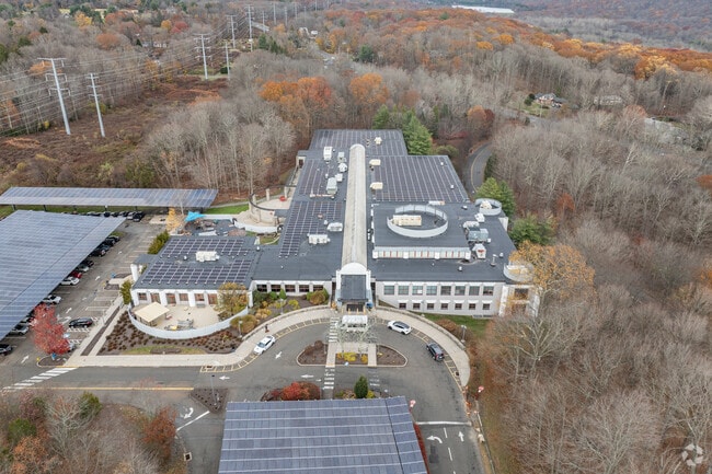
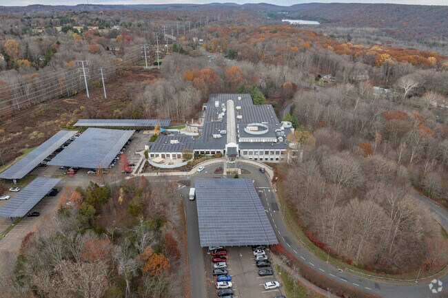
Property Detail
360 Amity Rd
New Haven, CT
NEW HAVEN
WOOD-001804-000030-000360
Connecticut
Commercialnec
53.48 AC
A
Woodbridge
B and X Area of moderate flood hazard, usually the area between the limits of the 100-year and 500-year floods.
Westchester/So Connecticut
NEARBY LISTINGS FOR SALE OR LEASE
DEMOGRAPHICS near 360 Amity Rd
1 mile
3 mile
5 mile
2025 Total Population
2,147
42,304
189,701
2030 Population
2,223
42,639
192,053
Pop Growth 2025-2030
+ 3.54%
+ 0.79%
+ 1.24%
Average Age
46
39
38
2025 Total Households
854
15,505
74,013
HH Growth 2025-2030
+ 3.75%
+ 0.64%
+ 1.31%
Median Household Inc
$125,500
$93,374
$72,585
Avg Household Size
2.40
2.50
2.30
2025 Avg HH Vehicles
2.00
2.00
1.00
Median Home Value
$467,741
$347,078
$329,433
Median Year Built
1970
1956
1956
Nearby Places
Map Layers
Map Styles
 Street
 Aerial
Layers
 Traffic
 Biking
Places
Listings with unknown addresses are not visible on the map
- Restaurants
- Banks
- Shops
- Fitness
- Groceries
PUBLIC TRANSPORTATION
COMMUTER RAIL
New Haven-State Street Station (Hartford Line - CONN DOT, New Haven Line - CONN DOT, Shore Line East - CONN DOT)
Drive
Walk
Distance
New Haven-State Street Station (Hartford Line - CONN DOT, New Haven Line - CONN DOT, Shore Line East - CONN DOT)
10 min
5.3 mi
AIRPORT
Tweed/New Haven
Drive
Walk
Distance
Tweed/New Haven
20 min
10.3 mi
Freight Ports
Port of New Haven
Drive
Walk
Distance
Port of New Haven
15 min
7.4 mi
Nearby Properties
Address
Land Use
TOTAL SIZE
Lot Size
Zoning
Address
Land Use
TOTAL SIZE
Lot Size
Zoning
111,274 SF
22.62 AC
CEM
Address
Land Use
TOTAL SIZE
Lot Size
Zoning
9,767 SF
33.63 AC
RM1
Address
Land Use
TOTAL SIZE
Lot Size
Zoning
57,339 SF
3.46 AC
RM2
Address
Land Use
TOTAL SIZE
Lot Size
Zoning
75,139 SF
3.54 AC
RM1
Address
Land Use
TOTAL SIZE
Lot Size
Zoning
6,784 SF
17.53 AC
RM1
Address
Land Use
TOTAL SIZE
Lot Size
Zoning
73,504 SF
7.97 AC
PDD 10
Address
Land Use
TOTAL SIZE
Lot Size
Zoning
25 AC
A
Address
Land Use
TOTAL SIZE
Lot Size
Zoning
576 SF
RS2
Address
Land Use
TOTAL SIZE
Lot Size
Zoning
46,962 SF
1.48 AC
RM1/RS
Address
Land Use
TOTAL SIZE
Lot Size
Zoning
86,644 SF
14 AC
PARK
Address
Land Use
TOTAL SIZE
Lot Size
Zoning
90,740 SF
1.97 AC
BA/RM1
Address
Land Use
TOTAL SIZE
Lot Size
Zoning
10.43 AC
M
Address
Land Use
TOTAL SIZE
Lot Size
Zoning
89,436 SF
14.41 AC
R2
Address
Land Use
TOTAL SIZE
Lot Size
Zoning
146,678 SF
43.44 AC
A
Address
Land Use
TOTAL SIZE
Lot Size
Zoning
2,180 SF
20.50 AC
PARK
Address
Land Use
TOTAL SIZE
Lot Size
Zoning
104,815 SF
14.50 AC
BA/RS2
Address
Land Use
TOTAL SIZE
Lot Size
Zoning
9,498 SF
8.85 AC
RS2
Address
Land Use
TOTAL SIZE
Lot Size
Zoning
56,573 SF
10.70 AC
RM1
Address
Land Use
TOTAL SIZE
Lot Size
Zoning
18,073 SF
2.81 AC
RM2
Address
Land Use
TOTAL SIZE
Lot Size
Zoning
203.57 AC
PARK
Address
Land Use
TOTAL SIZE
Lot Size
Zoning
203.58 AC
RS2
Address
Land Use
TOTAL SIZE
Lot Size
Zoning
192,769 SF
18.84 AC
R4
Address
Land Use
TOTAL SIZE
Lot Size
Zoning
7,551 SF
287.59 AC
RS2
Address
Land Use
TOTAL SIZE
Lot Size
Zoning
14,582 SF
1.94 AC
RM1
Address
Land Use
TOTAL SIZE
Lot Size
Zoning
47,423 SF
2.14 AC
R4
Address
Land Use
TOTAL SIZE
Lot Size
Zoning
3,264 SF
PDD 11
Address
Land Use
TOTAL SIZE
Lot Size
Zoning
51,368 SF
13 AC
R4
Address
Land Use
TOTAL SIZE
Lot Size
Zoning
60,056 SF
25.36 AC
A
Address
Land Use
TOTAL SIZE
Lot Size
Zoning
3,674 SF
3.21 AC
RM1
The World's #1 Commercial Real Estate Marketplace
Connect with us
© 2026 CoStar Group
The information above has been obtained from sources believed reliable. While we do not doubt its accuracy we have not verified it and make no guarantee, warranty or representation about it. It is your responsibility to independently confirm its accuracy and completeness. Any projections, opinions, assumptions, or estimates used are for example only and do not represent the current or future performance of the property. The value of this transaction to you depends on tax and other factors which should be evaluated by your tax, financial, and legal advisors. You and your advisors should conduct a careful, independent investigation of the property to determine to your satisfaction the suitability of the property for your needs.