Property Record
360 Cauterskill Rd, Catskill, NY 12414
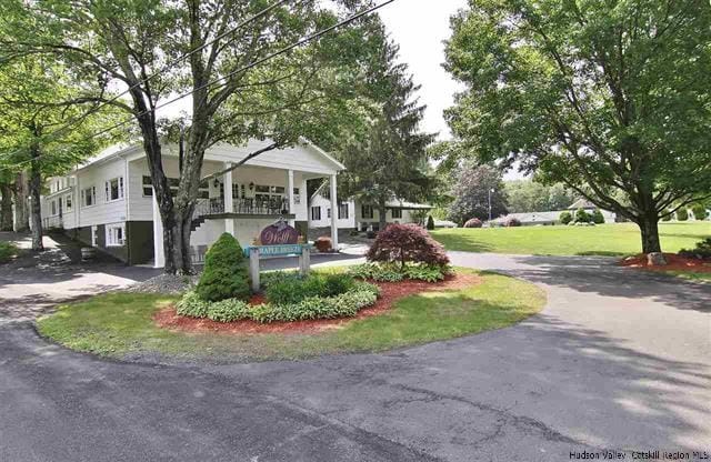

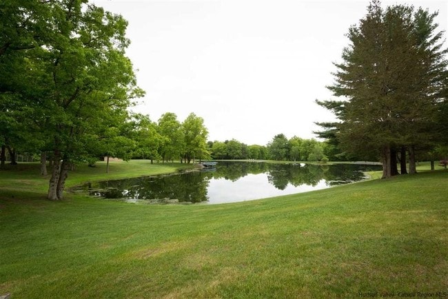
Property Detail
360 Cauterskill Rd
Residencehalldormitories
Greene
08 - GOVER
New York
B and X Area of moderate flood hazard, usually the area between the limits of the 100-year and 500-year floods.
15.000
2025
119.60 AC
2024
New York Southeast Area
081101
Albany/Schenectady/Troy
3,446 SF
192689-154-000-0006-015-000-0000
NEARBY LISTINGS FOR SALE OR LEASE
DEMOGRAPHICS near 360 Cauterskill Rd
1 mile
3 mile
5 mile
2025 Total Population
226
2,878
12,984
2030 Population
220
2,843
12,745
Pop Growth 2025-2030
(2.65%)
(1.22%)
(1.84%)
Average Age
44
45
45
2025 Total Households
95
1,265
5,799
HH Growth 2025-2030
(2.11%)
(0.95%)
(1.59%)
Median Household Inc
$70,714
$58,640
$64,820
Avg Household Size
2.20
2.20
2.20
2025 Avg HH Vehicles
2.00
2.00
2.00
Median Home Value
$237,500
$259,740
$264,983
Median Year Built
1964
1968
1956
Nearby Places
Map Layers
Map Styles
 Street
 Aerial
Transit
 Traffic
 Biking
Places
Listings with unknown addresses are not visible on the map
- Restaurants
- Banks
- Shops
- Fitness
- Groceries
SALE & LEASE HISTORY
LISTING DATE
SALE/LEASE

Feb 17, 2017
For Sale
Apr 27, 2021
For Sale
Nearby Properties
Address
Land Use
TOTAL SIZE
Lot Size
Zoning
Address
Land Use
TOTAL SIZE
Lot Size
Zoning
Address
Land Use
TOTAL SIZE
Lot Size
Zoning
Address
Land Use
TOTAL SIZE
Lot Size
Zoning
770 SF
99.10 AC
08 - GOVER
Address
Land Use
TOTAL SIZE
Lot Size
Zoning
75,751 SF
29.60 AC
02 - SINGL
Address
Land Use
TOTAL SIZE
Lot Size
Zoning
21,921 SF
95.10 AC
08 - GOVER
Address
Land Use
TOTAL SIZE
Lot Size
Zoning
61.18 AC
08 - GOVER
Address
Land Use
TOTAL SIZE
Lot Size
Zoning
4,098 SF
14.22 AC
02 - SINGL
Address
Land Use
TOTAL SIZE
Lot Size
Zoning
20,620 SF
27.20 AC
02 - SINGL
Address
Land Use
TOTAL SIZE
Lot Size
Zoning
352 SF
16.40 AC
02 - SINGL
Address
Land Use
TOTAL SIZE
Lot Size
Zoning
132 SF
391.30 AC
02 - SINGL
Address
Land Use
TOTAL SIZE
Lot Size
Zoning
Address
Land Use
TOTAL SIZE
Lot Size
Zoning
3,452 SF
193 AC
08 - GOVER
Address
Land Use
TOTAL SIZE
Lot Size
Zoning
2,080 SF
24.51 AC
07 - MIXED
Address
Land Use
TOTAL SIZE
Lot Size
Zoning
6,534 SF
11.60 AC
02 - SINGL
Address
Land Use
TOTAL SIZE
Lot Size
Zoning
99.96 AC
08 - GOVER
Address
Land Use
TOTAL SIZE
Lot Size
Zoning
14,460 SF
3 AC
02 - SINGL
Address
Land Use
TOTAL SIZE
Lot Size
Zoning
1,116 SF
187.80 AC
06 - INDUS
Address
Land Use
TOTAL SIZE
Lot Size
Zoning
2,656 SF
1.01 AC
03 - MULTI
Address
Land Use
TOTAL SIZE
Lot Size
Zoning
2,128 SF
84.80 AC
04 - FARM
Address
Land Use
TOTAL SIZE
Lot Size
Zoning
3,975 SF
1.72 AC
02 - SINGL
Address
Land Use
TOTAL SIZE
Lot Size
Zoning
3,664 SF
1.60 AC
02 - SINGL
Address
Land Use
TOTAL SIZE
Lot Size
Zoning
3,948 SF
12 AC
02 - SINGL
Address
Land Use
TOTAL SIZE
Lot Size
Zoning
3,059 SF
283.90 AC
08 - GOVER
Address
Land Use
TOTAL SIZE
Lot Size
Zoning
1,266 SF
9 AC
08 - GOVER
Address
Land Use
TOTAL SIZE
Lot Size
Zoning
4,408 SF
3.86 AC
02 - SINGL
Address
Land Use
TOTAL SIZE
Lot Size
Zoning
720 SF
2.50 AC
08 - GOVER
Address
Land Use
TOTAL SIZE
Lot Size
Zoning
3,368 SF
102.01 AC
02 - SINGL
Address
Land Use
TOTAL SIZE
Lot Size
Zoning
3.09 AC
02 - SINGL
Address
Land Use
TOTAL SIZE
Lot Size
Zoning
7,216 SF
13.30 AC
08 - GOVER
The World's #1 Commercial Real Estate Marketplace
Connect with us
© 2026 CoStar Group
The information above has been obtained from sources believed reliable. While we do not doubt its accuracy we have not verified it and make no guarantee, warranty or representation about it. It is your responsibility to independently confirm its accuracy and completeness. Any projections, opinions, assumptions, or estimates used are for example only and do not represent the current or future performance of the property. The value of this transaction to you depends on tax and other factors which should be evaluated by your tax, financial, and legal advisors. You and your advisors should conduct a careful, independent investigation of the property to determine to your satisfaction the suitability of the property for your needs.