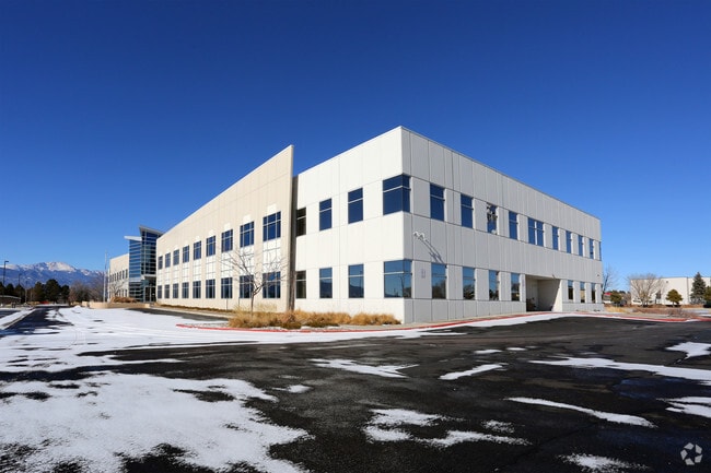
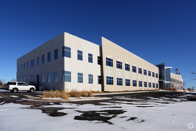
Property Record
360 Command Vw, Colorado Springs, CO 80915


Property Detail
360 Command Vw
54170-01-004
LOT 1 COWPERWOOD SAIC
Stateproperty
EL PASO
CS CAD-O
Colorado
B and X Area of moderate flood hazard, usually the area between the limits of the 100-year and 500-year floods.
1
0
14.24 AC
2025
Southeast
004008
Colorado Springs
87,577 SF
Colorado Springs, CO
NEARBY LISTINGS FOR SALE OR LEASE
DEMOGRAPHICS near 360 Command Vw
1 mile
3 mile
5 mile
2025 Total Population
10,093
61,301
193,021
2030 Population
10,911
63,248
196,966
Pop Growth 2025-2030
+ 8.10%
+ 3.18%
+ 2.04%
Average Age
31
35
36
2025 Total Households
3,320
22,311
73,547
HH Growth 2025-2030
+ 7.83%
+ 3.33%
+ 2.27%
Median Household Inc
$75,439
$73,026
$71,836
Avg Household Size
2.90
2.70
2.50
2025 Avg HH Vehicles
2.00
2.00
2.00
Median Home Value
$225,403
$369,238
$378,382
Median Year Built
2001
1989
1984
Nearby Places
Map Layers
Map Styles
 Street
 Aerial
Layers
 Traffic
 Biking
Places
Listings with unknown addresses are not visible on the map
- Restaurants
- Banks
- Shops
- Fitness
- Groceries
PUBLIC TRANSPORTATION
AIRPORT
City of Colorado Springs Municipal
Drive
Walk
Distance
City of Colorado Springs Municipal
7 min
2.2 mi
Freight Ports
Tulsa Port Of Catoosa
Drive
Walk
Distance
Tulsa Port Of Catoosa
732 min
687.9 mi
SALE & LEASE HISTORY
LISTING DATE
SALE/LEASE

Sep 25, 2016
For Lease
Sep 24, 2016
For Sale
Nearby Properties
Address
Land Use
TOTAL SIZE
Lot Size
Zoning
Address
Land Use
TOTAL SIZE
Lot Size
Zoning
8,806 SF
124.24 AC
PZ
Address
Land Use
TOTAL SIZE
Lot Size
Zoning
339,516 SF
1,090.76 AC
APD RPZ AP
Address
Land Use
TOTAL SIZE
Lot Size
Zoning
229,081 SF
9.87 AC
MX-N CU SS
Address
Land Use
TOTAL SIZE
Lot Size
Zoning
6,000 SF
3,790.85 AC
Address
Land Use
TOTAL SIZE
Lot Size
Zoning
117,648 SF
3,971.89 AC
APD
Address
Land Use
TOTAL SIZE
Lot Size
Zoning
704,240 SF
41.99 AC
BP/CR UV A
Address
Land Use
TOTAL SIZE
Lot Size
Zoning
8,096 SF
123.01 AC
PF APZ2 AO
Address
Land Use
TOTAL SIZE
Lot Size
Zoning
86,290 SF
8.01 AC
I-2 CAD-O
Address
Land Use
TOTAL SIZE
Lot Size
Zoning
75,169 SF
122.93 AC
I-3 CAD-O
Address
Land Use
TOTAL SIZE
Lot Size
Zoning
45,328 SF
3.87 AC
R-4 CAD-O
Address
Land Use
TOTAL SIZE
Lot Size
Zoning
185,508 SF
16.48 AC
BP/CR AO S
Address
Land Use
TOTAL SIZE
Lot Size
Zoning
45,579 SF
4.50 AC
MX-M AO
Address
Land Use
TOTAL SIZE
Lot Size
Zoning
24,437 SF
4.78 AC
BP/CR AO
Address
Land Use
TOTAL SIZE
Lot Size
Zoning
109,042 SF
15.56 AC
UNK
Address
Land Use
TOTAL SIZE
Lot Size
Zoning
210,964 SF
27.40 AC
BP APZ1 AO
Address
Land Use
TOTAL SIZE
Lot Size
Zoning
50,040 SF
8 AC
R-1 6 AO
Address
Land Use
TOTAL SIZE
Lot Size
Zoning
327,692 SF
16.30 AC
MX-N APZ2
Address
Land Use
TOTAL SIZE
Lot Size
Zoning
47,943 SF
6.15 AC
I-2 CAD-O
Address
Land Use
TOTAL SIZE
Lot Size
Zoning
353,072 SF
14.98 AC
CS CAD-O
Address
Land Use
TOTAL SIZE
Lot Size
Zoning
108,981 SF
5.73 AC
PDZ AO
Address
Land Use
TOTAL SIZE
Lot Size
Zoning
52,568 SF
15 AC
RS-6000 CA
Address
Land Use
TOTAL SIZE
Lot Size
Zoning
93,955 SF
5.72 AC
PDZ AO
Address
Land Use
TOTAL SIZE
Lot Size
Zoning
135,296 SF
11.67 AC
BP/CR UV A
Address
Land Use
TOTAL SIZE
Lot Size
Zoning
124,597 SF
10.89 AC
BP/CR AO
Address
Land Use
TOTAL SIZE
Lot Size
Zoning
359,481 SF
12.70 AC
CR RS-5000
Address
Land Use
TOTAL SIZE
Lot Size
Zoning
34,250 SF
8.74 AC
PUD CAD-O
Address
Land Use
TOTAL SIZE
Lot Size
Zoning
210,753 SF
20.68 AC
MX-M CU AP
Address
Land Use
TOTAL SIZE
Lot Size
Zoning
138,474 SF
12.44 AC
MX-M AO AP
Address
Land Use
TOTAL SIZE
Lot Size
Zoning
119,962 SF
14.06 AC
CR CAD-O
The World's #1 Commercial Real Estate Marketplace
Connect with us
© 2026 CoStar Group
The information above has been obtained from sources believed reliable. While we do not doubt its accuracy we have not verified it and make no guarantee, warranty or representation about it. It is your responsibility to independently confirm its accuracy and completeness. Any projections, opinions, assumptions, or estimates used are for example only and do not represent the current or future performance of the property. The value of this transaction to you depends on tax and other factors which should be evaluated by your tax, financial, and legal advisors. You and your advisors should conduct a careful, independent investigation of the property to determine to your satisfaction the suitability of the property for your needs.