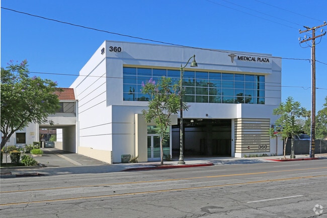
Property Record
360 E Las Tunas Dr, San Gabriel, CA 91776

Save to a Folder
{{folder.Name}}
{{folder.ListingIds.length}} Properties
{{folder.ListingIds.length}} Property
Create a New Folder
Property Detail
360 E Las Tunas Dr
5367-014-067
P M 399-35-36 LOT 1 CONDO UNIT 202 (AIRSPACE AND 1/7 INT IN COMMON AREA)
Officecondo
Los Angeles
SLC1-R3*
California
B and X Area of moderate flood hazard, usually the area between the limits of the 100-year and 500-year floods.
1
2025
0.43 AC
2025
Western SGV
481102
Los Angeles
1,160 SF
Los Angeles-Long Beach-Glendale, CA
NEARBY LISTINGS FOR SALE OR LEASE
DEMOGRAPHICS near 360 E Las Tunas Dr
1 mile
3 mile
5 mile
2025 Total Population
25,657
240,478
609,751
2030 Population
25,342
238,216
604,373
Pop Growth 2025-2030
(1.23%)
(0.94%)
(0.88%)
Average Age
43
43
42
2025 Total Households
8,577
80,605
210,777
HH Growth 2025-2030
(1.46%)
(1.15%)
(1.03%)
Median Household Inc
$99,258
$92,600
$94,204
Avg Household Size
2.90
2.90
2.80
2025 Avg HH Vehicles
2.00
2.00
2.00
Median Home Value
$957,332
$964,763
$935,634
Median Year Built
1957
1959
1960
Nearby Places
Map Layers
Map Styles
 Street
 Aerial
Layers
 Traffic
 Biking
Places
Listings with unknown addresses are not visible on the map
- Restaurants
- Banks
- Shops
- Fitness
- Groceries
PUBLIC TRANSPORTATION
COMMUTER RAIL
El Monte (San Bernardino Line - Southern California Regional Rail Authority (Metrolink))
Drive
Walk
Distance
El Monte (San Bernardino Line - Southern California Regional Rail Authority (Metrolink))
11 min
4.6 mi
Montebello/Commerce (Riverside Line - Southern California Regional Rail Authority (Metrolink))
Drive
Walk
Distance
Montebello/Commerce (Riverside Line - Southern California Regional Rail Authority (Metrolink))
18 min
8.6 mi
AIRPORT
Bob Hope
Drive
Walk
Distance
Bob Hope
34 min
23.2 mi
Long Beach (Daugherty Field)
Drive
Walk
Distance
Long Beach (Daugherty Field)
38 min
26.0 mi
Los Angeles International
Drive
Walk
Distance
Los Angeles International
43 min
29.4 mi
Freight Ports
Port of Long Beach
Drive
Walk
Distance
Port of Long Beach
41 min
27.9 mi
SALE & LEASE HISTORY
LISTING DATE
SALE/LEASE

Oct 04, 2021
For Lease
Nov 23, 2021
For Sale
Jun 02, 2022
For Sale
Jul 18, 2022
For Lease
Jul 14, 2025
For Sale
Aug 01, 2018
For Lease
Aug 01, 2018
For Sale
Apr 02, 2025
For Lease
Apr 01, 2025
For Lease
Nearby Properties
Address
Land Use
TOTAL SIZE
Lot Size
Zoning
Address
Land Use
TOTAL SIZE
Lot Size
Zoning
11,590 SF
14.43 AC
PSC*
Address
Land Use
TOTAL SIZE
Lot Size
Zoning
91,229 SF
206.59 AC
SOH
Address
Land Use
TOTAL SIZE
Lot Size
Zoning
516,474 SF
4.37 AC
ALCBD/DRD*
Address
Land Use
TOTAL SIZE
Lot Size
Zoning
192,792 SF
14.52 AC
PSR
Address
Land Use
TOTAL SIZE
Lot Size
Zoning
665,195 SF
29.38 AC
EMM2*
Address
Land Use
TOTAL SIZE
Lot Size
Zoning
247,960 SF
1.99 AC
SLC3
Address
Land Use
TOTAL SIZE
Lot Size
Zoning
572,320 SF
25.65 AC
EMM2*
Address
Land Use
TOTAL SIZE
Lot Size
Zoning
593,133 SF
SLR1YY
Address
Land Use
TOTAL SIZE
Lot Size
Zoning
452,713 SF
28.21 AC
PSC*
Address
Land Use
TOTAL SIZE
Lot Size
Zoning
334,580 SF
8.01 AC
EMM2
Address
Land Use
TOTAL SIZE
Lot Size
Zoning
220,142 SF
9.92 AC
SLR1VV
Address
Land Use
TOTAL SIZE
Lot Size
Zoning
198,728 SF
2.50 AC
SLR3YY
Address
Land Use
TOTAL SIZE
Lot Size
Zoning
331,660 SF
7.34 AC
RMC3*
Address
Land Use
TOTAL SIZE
Lot Size
Zoning
320,844 SF
6.45 AC
SLCHR*
Address
Land Use
TOTAL SIZE
Lot Size
Zoning
168,334 SF
7.41 AC
EMM2*
Address
Land Use
TOTAL SIZE
Lot Size
Zoning
121,746 SF
4.91 AC
EMR4*
Address
Land Use
TOTAL SIZE
Lot Size
Zoning
255,384 SF
6.74 AC
ARC2*
Address
Land Use
TOTAL SIZE
Lot Size
Zoning
95,187 SF
3.10 AC
EMC4*
Address
Land Use
TOTAL SIZE
Lot Size
Zoning
85,890 SF
2.33 AC
MPR2SCH*
Address
Land Use
TOTAL SIZE
Lot Size
Zoning
107,394 SF
4.40 AC
EMR4*
Address
Land Use
TOTAL SIZE
Lot Size
Zoning
53,306 SF
0.90 AC
ARC2
Address
Land Use
TOTAL SIZE
Lot Size
Zoning
189,263 SF
2.81 AC
EMM2*
Address
Land Use
TOTAL SIZE
Lot Size
Zoning
69,352 SF
4.78 AC
ARC2
Address
Land Use
TOTAL SIZE
Lot Size
Zoning
213,932 SF
7.03 AC
EMM2*
Address
Land Use
TOTAL SIZE
Lot Size
Zoning
48,018 SF
2.64 AC
SLC3*
Address
Land Use
TOTAL SIZE
Lot Size
Zoning
90,886 SF
TCC3*
Address
Land Use
TOTAL SIZE
Lot Size
Zoning
54,368 SF
1.20 AC
SLR3YY
Address
Land Use
TOTAL SIZE
Lot Size
Zoning
82,188 SF
1.20 AC
ALCBD/DRD*
Address
Land Use
TOTAL SIZE
Lot Size
Zoning
41,761 SF
3.25 AC
ALCPD-R1*
The World's #1 Commercial Real Estate Marketplace
Connect with us
© 2026 CoStar Group
The information above has been obtained from sources believed reliable. While we do not doubt its accuracy we have not verified it and make no guarantee, warranty or representation about it. It is your responsibility to independently confirm its accuracy and completeness. Any projections, opinions, assumptions, or estimates used are for example only and do not represent the current or future performance of the property. The value of this transaction to you depends on tax and other factors which should be evaluated by your tax, financial, and legal advisors. You and your advisors should conduct a careful, independent investigation of the property to determine to your satisfaction the suitability of the property for your needs.