Property Record
360 E State Line Rd, Toledo, OH 43612
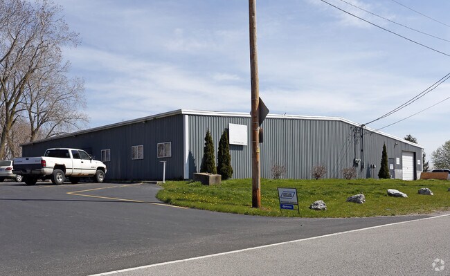
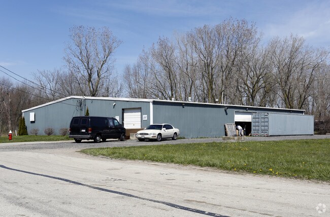
Property Detail
360 E State Line Rd
22-43527
NEW TOWNE SQUARE LOT 19
Warehouse
LUCAS
10-IL
Ohio
C and X Area of minimal flood hazard, usually depicted on FIRMs as above the 500-year flood level.
19
0
0.88 AC
2025
North Toledo
005704
Toledo
5,000 SF
Toledo, OH
NEARBY LISTINGS FOR SALE OR LEASE
DEMOGRAPHICS near 360 E State Line Rd
1 mile
3 mile
5 mile
2025 Total Population
3,361
41,188
142,827
2030 Population
3,409
40,769
142,403
Pop Growth 2025-2030
+ 1.43%
(1.02%)
(0.30%)
Average Age
41
40
40
2025 Total Households
1,449
17,531
60,591
HH Growth 2025-2030
+ 1.45%
(1.00%)
(0.34%)
Median Household Inc
$53,246
$58,928
$53,081
Avg Household Size
2.30
2.30
2.30
2025 Avg HH Vehicles
2.00
2.00
2.00
Median Home Value
$149,255
$140,020
$133,908
Median Year Built
1977
1963
1955
Nearby Places
Map Layers
Map Styles
 Street
 Aerial
Transit
 Traffic
 Biking
Places
Listings with unknown addresses are not visible on the map
- Restaurants
- Banks
- Shops
- Fitness
- Groceries
PUBLIC TRANSPORTATION
COMMUTER RAIL
Drive
Walk
Distance
15 min
7.8 mi
AIRPORT
Eugene F Kranz Toledo Express
Drive
Walk
Distance
Eugene F Kranz Toledo Express
44 min
25.3 mi
Detroit Metro Wayne County
Drive
Walk
Distance
Detroit Metro Wayne County
55 min
42.4 mi
SALE & LEASE HISTORY
LISTING DATE
SALE/LEASE

Nov 02, 2016
For Sale
Jan 17, 2017
For Sale
Nearby Properties
Address
Land Use
TOTAL SIZE
Lot Size
Zoning
Address
Land Use
TOTAL SIZE
Lot Size
Zoning
169.42 AC
10-IG
Address
Land Use
TOTAL SIZE
Lot Size
Zoning
1,972,579 SF
76.32 AC
10-IG
Address
Land Use
TOTAL SIZE
Lot Size
Zoning
693,900 SF
76.32 AC
10-IG
Address
Land Use
TOTAL SIZE
Lot Size
Zoning
Address
Land Use
TOTAL SIZE
Lot Size
Zoning
76.32 AC
10-IG
Address
Land Use
TOTAL SIZE
Lot Size
Zoning
169.42 AC
10-IG
Address
Land Use
TOTAL SIZE
Lot Size
Zoning
223,900 SF
17.26 AC
Address
Land Use
TOTAL SIZE
Lot Size
Zoning
163,962 SF
10.13 AC
Address
Land Use
TOTAL SIZE
Lot Size
Zoning
28.51 AC
10-IG
Address
Land Use
TOTAL SIZE
Lot Size
Zoning
450,000 SF
37.30 AC
Address
Land Use
TOTAL SIZE
Lot Size
Zoning
18.70 AC
Address
Land Use
TOTAL SIZE
Lot Size
Zoning
230,400 SF
18 AC
10-CR
Address
Land Use
TOTAL SIZE
Lot Size
Zoning
90,113 SF
8.12 AC
21-PO
Address
Land Use
TOTAL SIZE
Lot Size
Zoning
Address
Land Use
TOTAL SIZE
Lot Size
Zoning
20.67 AC
10-MX
Address
Land Use
TOTAL SIZE
Lot Size
Zoning
84,527 SF
7.79 AC
10-RS6
Address
Land Use
TOTAL SIZE
Lot Size
Zoning
47,600 SF
5.04 AC
Address
Land Use
TOTAL SIZE
Lot Size
Zoning
175,978 SF
10.02 AC
10-IL
Address
Land Use
TOTAL SIZE
Lot Size
Zoning
87,898 SF
9.17 AC
Address
Land Use
TOTAL SIZE
Lot Size
Zoning
170,528 SF
15 AC
Address
Land Use
TOTAL SIZE
Lot Size
Zoning
71,918 SF
7 AC
10-RS6
Address
Land Use
TOTAL SIZE
Lot Size
Zoning
328,898 SF
13.67 AC
10-IG
Address
Land Use
TOTAL SIZE
Lot Size
Zoning
302,338 SF
13.97 AC
Address
Land Use
TOTAL SIZE
Lot Size
Zoning
117,635 SF
5.30 AC
Address
Land Use
TOTAL SIZE
Lot Size
Zoning
90,507 SF
9 AC
10-CRSO
Address
Land Use
TOTAL SIZE
Lot Size
Zoning
106.75 AC
AC = AG
Address
Land Use
TOTAL SIZE
Lot Size
Zoning
75,127 SF
5.86 AC
Address
Land Use
TOTAL SIZE
Lot Size
Zoning
92,888 SF
20.24 AC
10-IL
Address
Land Use
TOTAL SIZE
Lot Size
Zoning
159,798 SF
8.32 AC
10-IL
Address
Land Use
TOTAL SIZE
Lot Size
Zoning
123,258 SF
23.59 AC
The World's #1 Commercial Real Estate Marketplace
Connect with us
© 2026 CoStar Group
The information above has been obtained from sources believed reliable. While we do not doubt its accuracy we have not verified it and make no guarantee, warranty or representation about it. It is your responsibility to independently confirm its accuracy and completeness. Any projections, opinions, assumptions, or estimates used are for example only and do not represent the current or future performance of the property. The value of this transaction to you depends on tax and other factors which should be evaluated by your tax, financial, and legal advisors. You and your advisors should conduct a careful, independent investigation of the property to determine to your satisfaction the suitability of the property for your needs.